Mexico Beach, FL
Thank you.
Mexico Beach, FL

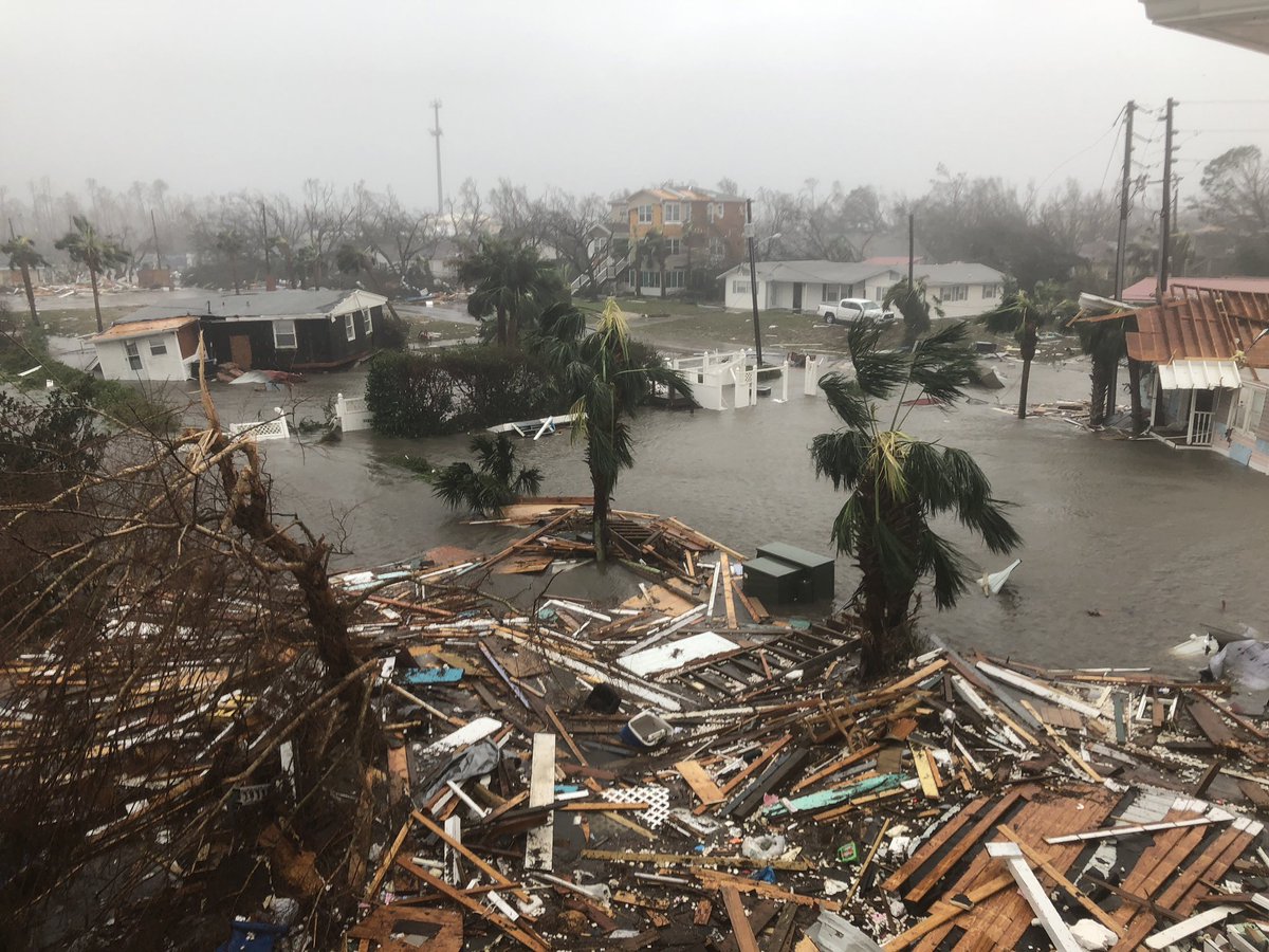
Panama City, FL
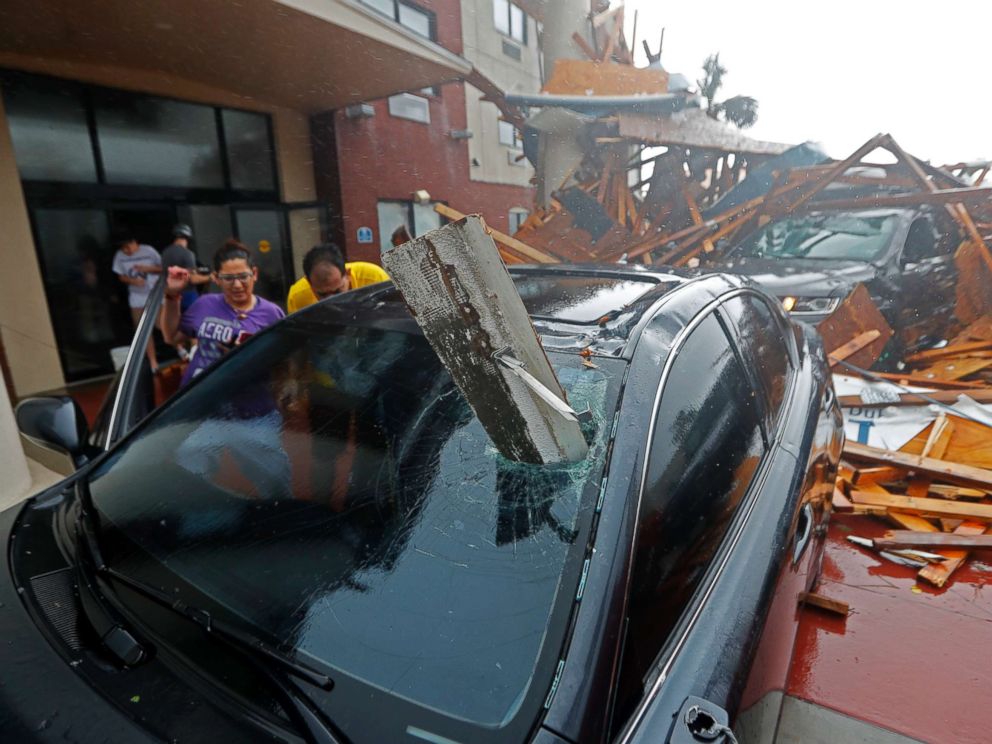
Panama City, FL
Thank you NN for this great thread and for responding to questions.
Just a nervous old woman here - having lived in SC at several locations and in Tybee Island when Dora threatened (had a 2 week old infant and a toddler - husband overseas).
Now in Beaufort, SC - glued to the Weather Channel and your thread - wondering what we will experience in the next few days. Neighbor said we are under curfew tomorrow, but can’t find anything official on a curfew. Schools are closed and Govt. offices.
God bless everyone and keep them safe.
Raining heavily in Atlanta.
I have a flight going into Charlotte in the morning,
Anyone in that area have a feel how the airport will be working tomorrow morning?
10-Oct-2018 7PM EDT Update Statement from the National Hurricane Center:
------------------------------------------------------------------------
000
TCUAT4
Hurricane Michael Tropical Cyclone Update
NWS National Hurricane Center Miami FL AL142018
700 PM EDT Wed Oct 10 2018
...7 PM EDT POSITION UPDATE...
...EYE OF MICHAEL MOVING THROUGH SOUTHWESTERN GEORGIA...
...LIFE THREATENING STORM SURGE ALONG THE COAST AND DAMAGING WINDS
INLAND CONTINUE...
NOAA Doppler radar data indicate that the eye of Michael is now
moving over southwestern Georgia.
Recently reported wind gusts include:
Albany Georgia airport: 67 mph (107 km/h)
Tallahassee International Airport: 61 mph (98 km/h)
Dothan Alabama airport: 60 mph (96 km/h)
Dangerous storm surge continues along the coast of the Florida
Panhandle. A National Ocean Service water level station at
Apalachicola is still reporting nearly 5 feet of inundation above
ground level.
SUMMARY OF 700 PM EDT...2300 UTC...INFORMATION
-----------------------------------------------
LOCATION...31.1N 84.9W
ABOUT 30 MI...45 KM NNW OF BAINBRIDGE GEORGIA
ABOUT 35 MI...55 KM WSW OF ALBANY GEORGIA
MAXIMUM SUSTAINED WINDS...100 MPH...155 KM/H
PRESENT MOVEMENT...NNE OR 30 DEGREES AT 13 MPH...20 KM/H
MINIMUM CENTRAL PRESSURE...950 MB...28.05 INCHES $$
Forecaster Stewart
------------------------------------------------------------------
Reports earlier in this FR thread by a FReeper Mom reporting her son out surfing the storm. Most of the reporters on camera didn't seem to be in much of a storm throughout the day.
Governor Scott, on Fox, says people should "remain cautious". Which seems fair. Could have been much worse.
Bet tomorrow will be sunny on the coast.
Maybe a discussion in order as to why all of the end of the world, worst ever storm, biggest, etc., that seems to accompany each storm (and gets blamed on Global Warming), yet the storms are less, some even fizzles. Is this just run amok emotionalism, sensationalism, whatever to pump up ratings, scare little old ladies, etc.?
From NHC:
000
WTNT44 KNHC 112053
TCDAT4
Tropical Storm Michael Discussion Number 21
NWS National Hurricane Center Miami FL AL142018
500 PM EDT Thu Oct 11 2018
Satellite and radar data show that Michael’s rain shield is
beginning to expand northward and northwestward, and that cooler and
drier air is starting to wrap around the western portion of the
circulation. These trends indicate that Michael’s transition to an
extratropical low has started. There have been recent observations
of 40 to nearly 45 kt sustained winds along the southeastern coast
of North Carolina, so the initial intensity remains 45 kt. Little
change in strength is expected through this evening, but Michael is
forecast to quickly intensify after it completes extratropical
transition and exits the east coast of the United States tonight.
The official intensity forecast is based on guidance from the NOAA
Ocean Prediction Center.
It should also be noted that an area of damaging wind gusts of up to
50 kt has developed around the northwest side of the circulation
over central North Carolina and Virginia this afternoon. As a
result, the gust factor has been increased in this advisory, as this
area of strong winds will spread northward and eastward across
portions of eastern Virginia and northeastern North Carolina this
evening and tonight.
Michael is moving northeastward or 050/21 kt. The storm will
continue to accelerate as it become further embedded within the
mid-latitude westerlies. The post-tropical cyclone will race
across the north Atlantic during the next few days, before slowing
down late in the period before it weakens and dissipates. The
track guidance continues to be in good agreement and little change
was required from the previous NHC track forecast.
Gale- to storm-force winds are expected over portions of the
Mid-Atlantic coast as Michael exits the U.S. east coast and becomes
post-tropical. Non-tropical high wind watches, warnings, and
advisories have been issued by local NWS offices for wind hazards in
these areas north of Duck, North Carolina.
Key Messages:
1. Life-threatening flash flooding is occurring over portions of
North Carolina and southern Virginia and will continue through the
evening.
2. Damaging winds are spreading eastward across portions of central
and eastern North Carolina, and will continue through this evening.
These winds have the potential to cause tree and structural damage.
Strong winds are also expected over portions of southeastern
Virginia and the Virginia Eastern Shore tonight as Michael becomes
post-tropical.
3. Dangerous storm surge is possible tonight along the sound side of
the North Carolina Outer Banks from Ocracoke Inlet to Duck, where a
Storm Surge Watch is in effect.
FORECAST POSITIONS AND MAX WINDS
INIT 11/2100Z 36.1N 78.8W 45 KT 50 MPH...INLAND
12H 12/0600Z 38.1N 74.7W 45 KT 50 MPH...POST-TROP/EXTRATROP
24H 12/1800Z 41.2N 66.5W 60 KT 70 MPH...POST-TROP/EXTRATROP
36H 13/0600Z 44.5N 55.5W 60 KT 70 MPH...POST-TROP/EXTRATROP
48H 13/1800Z 47.0N 42.0W 60 KT 70 MPH...POST-TROP/EXTRATROP
72H 14/1800Z 48.5N 17.5W 50 KT 60 MPH...POST-TROP/EXTRATROP
96H 15/1800Z 46.5N 7.0W 30 KT 35 MPH...POST-TROP/EXTRATROP
120H 16/1800Z...DISSIPATED
$$
Forecaster Brown
Well, we made it through the storm here on the GA/AL border with a 16 hour power outage and a yellow pine across the road that blocked everyone’s exit. We each burned a vacation day and stayed indoors until the sun came out. The yard is a carpet of sweetgum leaves, tree branches, and pine straw, but we otherwise made it out OK. Prayers up for those folks in the Panama City area who went through what they did. Ours was a kiddie ride compared to their Roller Coaster From Hell.

On/Off Hurricane List Mash Here--> 
So I will not insult you further. Just ask you to re-examine your premises. Yeah, I agree, sometimes the media and the government hypes this stuff. But also, given that intensity forecasts are the weakest link of what the NHC does, this storm shows that we cannot just assume that we are getting a marginal Cat 3 in a day or so when they can blow up out of nowhere to the edge of Cat 5. Because that is clearly what happened here.
Folkes, I live and work in Walton county which borders Bay county (Panama City). Tonight a man who lives in Panama City came to work for the 1st time since the hurricane. This is not make believe conspiracy stuff. This is a first hand report. He says there is a media blackout. That martial law is in effect. That looting is beyond rampant. That homeowners are doing 24-7 stay awake armed shifts, that 2 police have already been shot and killed by looters, that a dusk curfew is in place unless you can prove a reason to be out (he said he would be stopped and questioned at the inlet bridge tonight and would have to show his work clock out sheet, and that looters were being shot on site by law enforcement. Anyone else hear of this? He claims media is being ordered to not report the scale of the looting and deaths.