Posted on 10/09/2018 4:49:06 PM PDT by NautiNurse
Major Hurricane Michael is churning toward the northeastern Gulf of Mexico coast. Florida Governor Rick Scott declared a state of emergency Monday for 35 counties with mandatory coastal evacuations in the FL Panhandle. 1,250 National Guard troops are aiding the process and more than 4,000 more placed on standby.
FEMA is already on the ground in Florida; other federal agencies are also preparing to assist people in the storm's path.
Alabama Gov. Kay Ivey on Monday declared a state of emergency for the entire state. Georgia Governor Nathan Deal issued a state of emergency for 92 counties ahead of Hurricane Michael landfall.
Meanwhile, Tallahassee city government (Andrew Gillum, Mayor & D'Rat FL Gubernatorial candidate) offices are "closed until further notice." Tallahassee International Airport is suspending commercial flight activity as 12:01 a.m. ET on Wednesday but expects to resume activity on Thursday.
The U.S. military moved its aircraft from the Panhandle on Monday. Roughly 50 F-22 stealth fighter jets — valued around $150 million each — have been relocated from the Tyndall Air Force Base, while the U.S. Navy said it is moving all its training aircraft from Pensacola.
Energy Production The Bureau of Safety and Environmental Enforcement (BSEE) on Tuesday estimated that around 726 MMcf/d (28.4%) of natural gas production and 670,831 b/d (39.5%) of oil production in the GOM had been shut in ahead of the storm.
As of midday Tuesday, 75 platforms and three rigs had been evacuated, while eight dynamically positioned rigs had been moved out of the storm’s path as a precaution, according to BSEE.
Gulf of Mexico Satellite Channels
Public Advisories
NHC Discussions

NHC Local Weather Statements/Radar Key West FL
NHC Local Weather Statements/Radar New Orleans, LA
NHC Local Weather Statements/Radar Mobile AL/Pensacola FL
NHC Local Weather Statements/Radar Panama City, FL
NHC Local Weather Statements/Radar Tallahassee, FL
NHC Local Weather Statements/Radar Tampa Bay, FL
There were on other side of eye. Less surge. A little less wind.
I’m soooo sorry about that post. I just got home and didnt have a chance to get back to you. Turns out someone was messing around with the doc who said there was a fire. He’s got a house in PCB ...he was in a panic.
I’ll ask mod to delete post.
they will be getting ready to be hit — might be closed or have equipment that can’t commit, IMHO
see this for the forcast for 12 hours from now for tropical storm force winds:
https://www.nhc.noaa.gov/refresh/graphics_at4+shtml/212416.shtml?tswind012?#wcontents
As time goes on that wind continues to push northeast eventually getting to the DC area as it goes off-shore.

Yeah, that’s a nothing burger. Just a little wind.
People are over reacting, aren’t they?
Where was that?
I found a “non-facebook” version of it just for you!
Storm chasers drive right into path of Hurricane Michael,
take cover as car floats away
https://foxsanantonio.com/news/nation-world/storm-chasers-drive-right-into-path-of-hurricane-michael-take-cover-as-car-floats-away
Very lucky the eye hit between all these towns and cities .
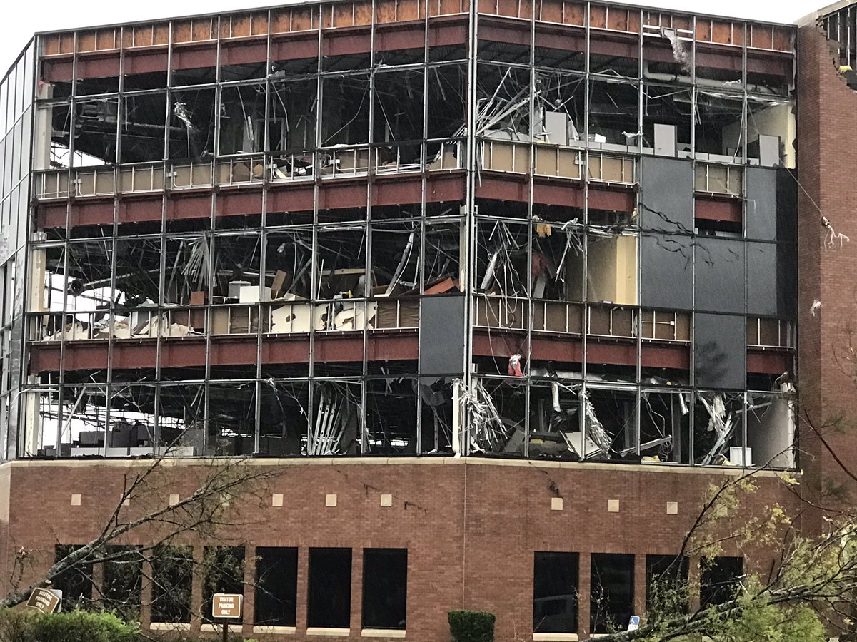
A bank in Panama City.
The wind gage measured a 118 mph gust...not 188. Sheesh.
10-Oct-2018 7PM EDT Update Statement from the National Hurricane Center:
------------------------------------------------------------------------
000
TCUAT4
Hurricane Michael Tropical Cyclone Update
NWS National Hurricane Center Miami FL AL142018
700 PM EDT Wed Oct 10 2018
...7 PM EDT POSITION UPDATE...
...EYE OF MICHAEL MOVING THROUGH SOUTHWESTERN GEORGIA...
...LIFE THREATENING STORM SURGE ALONG THE COAST AND DAMAGING WINDS
INLAND CONTINUE...
NOAA Doppler radar data indicate that the eye of Michael is now
moving over southwestern Georgia.
Recently reported wind gusts include:
Albany Georgia airport: 67 mph (107 km/h)
Tallahassee International Airport: 61 mph (98 km/h)
Dothan Alabama airport: 60 mph (96 km/h)
Dangerous storm surge continues along the coast of the Florida
Panhandle. A National Ocean Service water level station at
Apalachicola is still reporting nearly 5 feet of inundation above
ground level.
SUMMARY OF 700 PM EDT...2300 UTC...INFORMATION
-----------------------------------------------
LOCATION...31.1N 84.9W
ABOUT 30 MI...45 KM NNW OF BAINBRIDGE GEORGIA
ABOUT 35 MI...55 KM WSW OF ALBANY GEORGIA
MAXIMUM SUSTAINED WINDS...100 MPH...155 KM/H
PRESENT MOVEMENT...NNE OR 30 DEGREES AT 13 MPH...20 KM/H
MINIMUM CENTRAL PRESSURE...950 MB...28.05 INCHES $$
Forecaster Stewart
------------------------------------------------------------------
A bit of good news.
https://www.facebook.com/captandersons/
Capt. Anderson’s Restaurant
1 hr ·
We are ok, no major damage,we hope everyone else is staying safe! We will keep up with updates.
Well...he is a queer snowflake.
Josh Morgerman is reporting catastrophic damage in Panama City. Basically, they probably got the same intensity of winds that trashed Rockport, TX during Harvey. But Panama City is much larger than Rockport.
They are in Panama City Beach - that community did not get an eyewall hit. Panama City did, and from what I am reading they suffered catastrophic damage.
Shep mentioned oysters several times today. Projecting, I guess.
I was just reading Josh on Twitter. .destruction is awful.
Disclaimer: Opinions posted on Free Republic are those of the individual posters and do not necessarily represent the opinion of Free Republic or its management. All materials posted herein are protected by copyright law and the exemption for fair use of copyrighted works.