
Posted on 09/04/2017 2:02:19 PM PDT by NautiNurse
While thoughts and prayers are with our Texas FRiends and neighbors, we are at the peak of the Atlantic Tropical Storm season. Hurricane Irma continues its trek from Cape Verde across the pond and toward the Hebert Box (see below). People with interests in the Southeastern U.S. and Gulf of Mexico should be alert to the forecast path updates for this powerful storm. It is important to note that the average NHC track errors are about 175 and 225 statute miles at days 4 and 5, respectively.
Hurricane Irma originally had a small wind field. In the past 24 hours, however, the wind field has expanded with hurriance force winds up to 40 miles from the center, and tropical storm force winds up to 140 miles from the storm center.
FL Governor Rick Scott reminds Floridians: Families should take time today to make sure you have a disaster plan and fully-stocked Disaster Supply Kit. Florida residents from West Palm Beach to Tampa Bay are heeding the alert. Store shelves are emptying of bottled water.


Mash image to find lots of satellite imagery links
Public Advisories
NHC Discussions
NOAA Local Weather Statements/Radar San Juan, Puerto Rico
NHC Local Weather Statements/Radar Miami, FL
NHC Local Weather Statements/Radar Key West, FL
Buoy Data Caribbean
Buoy Data SE US & GOM

Hebert Box - Mash Pic for Tutorial
Credit: By J Cricket - Modification of map from Wiki
I’ve been to Anguilla. Interesting spot. Goats roamed freely throughout the island. We called them the Anguilla dingoes.
Granted I live well away from this mess, up in NY but I was out today stocking up on things.
I don’t really expect any weather from either of these, unless Irma comes due north, but the refineries are in the Gulf and TX and there’s just no telling the economic impact this series of storms could have on food supplies and gas for the rest of the country.
That is beautiful.
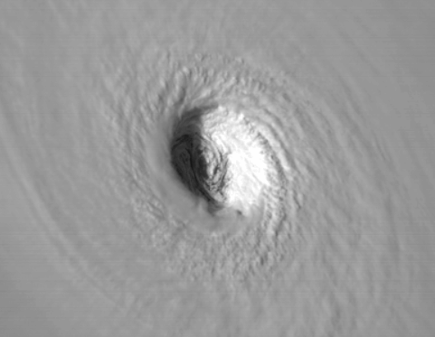
How big is that eye?
Lee ? That’s racist is it not ? /sarc
My daughter just moved to Georgetown. What’s the scoop on the lake there?
It appears TD 13 may just go back to the Mexican shoreline. But who knows if it goes into the central Gulf of Mexico with its very warm waters....
Not wishing that on anyone, but let’s hope so before it gets any stronger.
Bump THIS!!!!
I swear, every single run of these models there are guys on the weather sites that go nuts. And nearly all of them know better:) They can’t help it. The thing is with this girl, she has lots of suitors and she’s flirting with them all. Even she doesn’t know which one she’ll choose yet. Picky, apparently.
Not sure, haven’t seen a vortex report from Hurricane Hunters lately.
plane now inbound
Holy crap! Thanks for posting your graphics, db.
I think.
Last night, I could literally envision a child’s toy top, spinning off the edge of a rough piece of sandpaper, onto a polished marble surface...and going supersonic.
750 mph is a bit out of reach for Irma, but you get the idea. This just about HAD to intensify dramatically.
Okeechobee is big enough to “slosh” to one side, under the same impetus that drives storm surge in the open ocean.
In the 1920s, the heavily populated areas on some sides of the lake were only protected by 2 to 3 foot tall, poorly constructed levees.
The casualties were horrific, and almost certainly vastly under-reported, due to comms problems and racial bias.
Apparently an NHC guy in SWFL just teared up on a local news piece when asked about the damage to S FL.
916 mb pressure extrapolated to surface. Getting stronger.
18Z GFS EVEN MORE NORTH AND EAST
The pressure is dropping during an eye wall replacement? Or did I read the discussion incorrectly?
radar showing an outer eye ring trying to from..perhaps the very first stages
Disclaimer: Opinions posted on Free Republic are those of the individual posters and do not necessarily represent the opinion of Free Republic or its management. All materials posted herein are protected by copyright law and the exemption for fair use of copyrighted works.
