Posted on 10/06/2016 4:10:09 AM PDT by NautiNurse
Hurricane Matthew is big, bad and just downright scary, with iminent and sustained impacts to U.S. mainland. Florida Governor Rick Scott issued a state of emergency for all of Florida and disaster operations are activated. More than 1.5 million Floridians reside in current evacuation zones. Governor Scott has spoken with utilities across the state to ensure utilities are pre-positioned and there are no unmet needs. Multiple coastal hospitals have been evacuated. Meanwhile, feckless President Barack Hussein Obama is personally monitoring the progress of the storm.


Cone of Death Historic Archive Loop

Mash image to find lots of satellite imagery links
Public Advisories
NHC Discussions
NHC Local Hurricane Statements
Florida Radar Loop
Florida & Eastern Gulf Buoy Locations
SE Atlantic Coast Buoy Locations
SE U.S. Radar Sector
FL Emergency Management Disaster Info by County
Local News Sources: Palm Beach Post
WFLC FOX 29
WPTV West Palm Beach
WPEC CBS 12 Palm Beach
My News 13 Brevard
WOFL FOX 35 Orlando
WFTV 9 ABC News Orlando
TC Palm (Treasure Coast)
Space Coast Daily
If the info above doesn't satisfy your need for speed and graphics, strap yourself in for a ride to Mike's Weather Page

Hope you aren’t in those areas or at least safe if you are.

The quiet is what I noticed. It was lovely.
Thank you - we are safe, but it is hard to see an area you know so well, so completely transformed. All of us, all along the path will survive, but we will never forget Matthew...
May God bless you FRiend.
Tatt
Oh I’m glad your safe.....yes it is indeed hard to see an area you know be transformed in this way......I lived in Jacksonville Fl. so seeing the area there get so much water was difficult, especially since my brother lives there still and went thru this ordeal.....he’s safe too but lost part of his fence and the first tree he ever planted on his property went down.
Jacksonville is going to take some heavy lifting over these next weeks, they got hit pretty hard overall.
Bless you as well....
CW
I can just imagine what Darien looks like. Underwater with debris, gators and sharks in the streets, my condo building damaged or ripped apart by the winds...
The one thing I learned from my experience in Georgia was to love small town life. That's why I am where I am today.
First thing we noted on arrival was the immense and beautiful quiet....especially that night as we sat near a bonfire, under the Milky Way Stars seen more clearly then I've ever seen them....everything was more vivid. We were at the highest elevation so we overlooked all the area where the Elk Run.

We had the entire 2nd and 3rd floor to ourselves....

Those two rows of windows are the cathedral designed living room....with a castle type stairway in the middle going up to the sleeping quarters which have a surround open hallway....it's a grand place to stay and VERY reasonable.

Private road with a gate below this one that's locked tighter than a drum so no thru traffic whatsoeverr!
A hail hello Publius!! Always so good to hear from you :) As of yet I have not read of any damage to Darien, but then again, here we all are, wandering through the vastness of the internet, looking for a little news from home, or of family and friends.
CW, we understand completely. Jacksonville and St. Augustine are also very old, very familiar favorites for us. Now, Really dating myself here, but hubby and I both can remember the “old” A1A route to Crescent! Nature definitely plays by her own set of rules, and I just try to remember the beauty, and learn the hard lessons from a safe distance.
All the best to you both,
Tatt
That's why I'm wondering about Darien.

It’s at the very bottom end of that box. Darien is where the delta branches of the Altamaha River go under US 17.
Welcome back to the realm of the energized!
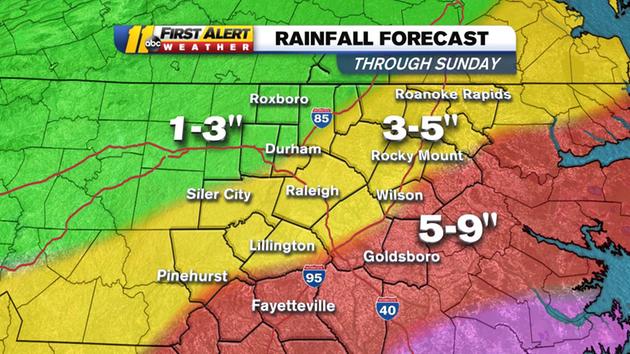
Am here in central-East NC waiting for the rains to start. We are told 4-6 inches here in central NC but as your chart shows - major flooding rains down east.
We have also been told 35 MPH winds with gusts 45 to 50 MPH.
So, trees may be coming down all over. Power outages predicted.
I just hope Matthew definitely turns out to sea.
The rains have started here in central NC.
Has Matthew begun it’s sharp turn East? I sure hope it does and that it has not fooled the forecasters.
Well I’m still up but was writing another rather lengthy post so I didn’t see your post for a bit there.
Yes, I suspect you;ll have flooding and power outages, and trees or limbs down even though it’s not as powerful as it was prior.......it’s the water that’s doing the greatest damage everywhere in Florida and up the coast.....few seem to understand how powerful water is sometimes.
I’ll take a look now and see what’s happening on your coast....maybe have some photos....
....so it looks like Rain will be the problem Preliminary totals suggest some areas could see more than 6 inches of rain.


very stormy weather conditions Saturday and Saturday night with widespread heavy rain, isolated severe thunderstorms and tornadoes, widespread tropical storm winds, and the possibility marginal hurricane wind gusts.
- improving conditions between Sunday morning and Sunday afternoon, lingering flooding issues notwithstanding.
Barring any drastic changes in storm track, specific impacts will include:
- widespread rain totals on the order of 8 to 12 inches with bands of much higher amounts likely. Poor-drainage and lowland flooding is likely. Clear storm drains, be alert for the issuance of National Weather Service flood bulletins, and of course: never drive through water-covered roads.
- widespread winds in the 25 to 50 mph range with the possibility of some 60+ gusts for, especially, coastal counties. Sporadic to scattered tree damage and power outages will be possible.
- significant wave action with breaking waves of 6+ feet in some sets. The risk of rip currents and beach erosion will be extremely high, and minor to locally moderate tidal flooding is possible.
- minor surge for the coastal areas of Horry, Brunswick, New Hanover, Pender and Onslow counties - highest potential will be for Brunswick County, where surge may be near or slightly higher than highest astronomical high tide. Water rises above 1 - 3’ are possible in these areas.
- extremely poor offshore weather conditions, including hurricane-quality winds and seas. Mariners are absolutely advised to stay in-port.
Disclaimer: Opinions posted on Free Republic are those of the individual posters and do not necessarily represent the opinion of Free Republic or its management. All materials posted herein are protected by copyright law and the exemption for fair use of copyrighted works.