Skip to comments.
Malaysia Airlines MH370: Tony Abbott says possible debris found in Indian Ocean [live thread]
ABC.net.au ^
| March 19, 2014
Posted on 03/19/2014 8:22:10 PM PDT by rdl6989
Prime Minister Tony Abbott has announced objects possibly related to the search for the missing Malaysian Airlines plane have been found in the southern Indian Ocean.
TOPICS: Australia/New Zealand; Breaking News; News/Current Events
KEYWORDS: australiasearch; iran; malaysia; mh370; planecrash; waronterror
Navigation: use the links below to view more comments.
first previous 1-20 ... 421-440, 441-460, 461-480 ... 521-522 next last
To: TEARUNNER14
Correction! In due time God will reveal what has happened even though it might not be the truth. It will depend on if the media is up to the truth. Joking about media.
441
posted on
03/20/2014 8:38:03 PM PDT
by
TEARUNNER14
(Abortions on demand! " HELL ON DEMAND FOR YOU ABORTIONIST" SAYS GOD!)
To: Sarah Barracuda
I think Sean and Megyn have tried but he swerves around that question. Tonight when Sean asked he came back with the quip “I’m in witness protection”. I honestly can’t decipher if he truly has intel or it’s just his opinion.
442
posted on
03/20/2014 8:57:00 PM PDT
by
bonfire
To: Sarah Barracuda

Gen. McInerney said Allama [ Iqbal International ] Airport was the same distance from Malaysia Airlines Flight 370 point of departure, Kuala Lumpuras, its original destination airport, Beijing, China.
Gen. McInerney also said that if Pakistan didn't speak up soon, they would be complicit.
Now I ask you, if you heard another large jet land at an International Airport that had on average
4 other arrivals all around the same time, would you suspect anything out of the ordinary ?
I just want to inform you that arrivals make a lot less noise than
departures.
Also, from an air traffic controller's point of view, there ARE PROCEDURES for clearing a "RADIO OUT" or "NORDO" aircraft to land, and once the aircraft is safely down, it's up to the Airfield Base Operations Officer and the Fire Chief as to how to handle it.
They would probably have to fuel to refuel the 777 with little or no extra coordination.
Israel, are you listening?
443
posted on
03/20/2014 9:04:33 PM PDT
by
Yosemitest
(It's Simple ! Fight, ... or Die !)
To: bonfire
I dont know..Im not really familiar with him other than he’s a General which should mean a lot but the whole “Siri” thing that I guess rubbed me the wrong way, like he was just guessing. If he has actual intelligence that’s a different story.
I would believe that perhaps that this was just a tragic accident, like hypoxia(Payne Stewart) or that there was some kind of electrical fire in the cargo hold(Which they still havent told us what they had in there) if it wasn’t for the fact that the plane turned West at least 12 minutes BEFORE “Alright Good Night” so either these pilots were psychic or had some crazy premonition that something was about to happen or something else is going on here. You don’t say all is good when you have a fire behind you, or smoke..they had every chance at that point to say something was wrong and they did not..if that information proves to be wrong different story, but until its proven false I believe this was some kind of crazy suicidal pilot or the plane is somewhere else
Also heard a story tonight that the Pilot Shah made a phone call in the cockpit before the plane took off, wonder who he was calling..could be important, could be routine
To: mulder1
That's not what I heard.
Gen. McInerney said
Allama [ Iqbal International ] Airport was
the same distance from Malaysia Airlines Flight 370 point of departure, Kuala Lumpuras, its original destination airport, Beijing, China.
Gen. McInerney also said that if Pakistan didn't speak up soon, they would be complicit.
Now take a close look at the arc map below, three graphics down and center.
Notice that Pakistan is within the "1 Hour Emergency Fuel Range" (second circle around the red arc), past the "20 minute safety fuel (first circle around the red arc).
So it meets the criteria of being within the Red Arc "handshake" or the last ACARS Satellite "ping" and within fuel range of the Boeing 777 to Allama Iqbal Int'l Airport, Pakestan.
It sounded like Gen. McInerney was all but threatening Pakistan to own up to it now, or suffer the consequences.
 Someone sent me another piece of information
 you should read.
" Someone on another thread posted a link to a theory that the missing 777 used SIA68 (Singapore Airlines flight 68) to cloak their own airplane until they could get across the Indian Ocean, away from primary radar.
http://keithledgerwood.tumblr.com/post/79838944823/did-malaysian-airlines-370-disappear-using-sia68-sq68 "
That's a really good theory.
But there's problems when you try to match it with the

the arc graph (click on it for more detailed info) that shows the estimated range of the aircraft with it's remaining fuel IF it was flying at its MAXIMUM SPEED or 7 hours 30 minutes of fuel.
Now, from the article:
this statement towards the end of his article." A satellite was able to pick up a ‘ping’ from the plane until 08:11 local time,more than seven hours after it lost radar contact,
although it was unable to give a precise location.
Mr Razak went on to say that based on this new data, investigators ‘have determined the plane’s last communication with a satellite was in one of two possible corridors –north from the border of Kazakhstan and Turkmenistan through to northern Thailand,
and south from Indonesia to the southern Indian Ocean. "
My problem is ~ I don't know how accurate that Red Arc map is,
and I don't know whether to trust it or not.
I've been trying to match up the numbers on a "guess-ta-mated" flight path.
You can narrows down the search area if you take all the Satellite "Handshakes" into consideration for the search of runways/landing strips that Malaysia Airlines Flight 370 could have landed on.
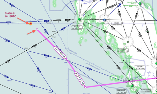
The Way Point on the northwet side of her screen is "IGREX" on Jet Route "P628" where the heading changes to a more northerly direction 320 degrees to PORT BLAIR Navaid.
That's a total airborne time of about 4 hours 40 minutes from takeoff.
The arc graph shows the estimated range of the aircraft with it's remaining fuel IF it was flying at its MAXIMUM SPEED or 7 hours 30 minutes of fuel.
Now, from the article:
this statement towards the end of his article." A satellite was able to pick up a ‘ping’ from the plane until 08:11 local time,more than seven hours after it lost radar contact,
although it was unable to give a precise location.
Mr Razak went on to say that based on this new data, investigators ‘have determined the plane’s last communication with a satellite was in one of two possible corridors –north from the border of Kazakhstan and Turkmenistan through to northern Thailand,
and south from Indonesia to the southern Indian Ocean. "
That's
7 hours and 31 minutes after takeoff.
"... The plane departed for an overnight flight from Kuala Lumpur to Beijing at 12:40 a.m. on March 8.
Its communications with civilian air controllers were severed at about 1:20 a.m., and the jet went missing ... "
That leaves
2 Hours 50 minutes to travel from "IGREX" on Jet Route "P628 to an undefined point on that arc of 7 hours 30 minutes from takeoff.
Let's say that the pilot leans the engines out to get the most out of his fuel for distance with the remaining time for "IGREX" and gets 3 hours if time,
before he hits his 20 minutes safety margin on fuel and then starts to burn his 1 hour emergency fuel.
At maximum speed of Mach 0.89 (590 mph, 950 km/h, 512 knots) at a cruise altitude of 35,000 ft , that would
allow him 1770 miles of distance (to the red arc), before hitting his reserves.
Let's
assume that since he stayed on the Jet Routes, he continued to stay on the Jet Routes.
Now take that information and
the arc ping map (important to view this map at this link for more details) along with the jet route map, and you can find possible links.
Now I run the numbers on the Jet Routes starting from "IGREX" on Jet Route "P628" and starting
subtotaling for a target of 1770 Nautical Miles.Take a look from
SkyVector.com.
Jet Route P628 NW IGREX 151 NM to Port Blair
Port Blair 272 NM to VATLA
VALTA 173 NM to URKOK
URKOK 172 NM to KAGUL
KAGUL 51 NM to DORIL
DORIL 99 NM to OPASA
OPASA 75 NM to IKINA
IKINA 28 NM to OPONI
OPONI 121 NM to ASOPO or JABALPUR
-----------
1,142 NM subtotal
---------------
Change route to W66 North to KHAJURAHO
ASOPO 97 NM to KKJ
Change route to W40 NNE via KANPUR to LUCKNOW
KJJ 72 NM to IGONA
IGONA 28 NM to LUCKNOW
Change route to M890 Northwest to SARSAWA
LUCKNOW 87 NM to JALABAD
JALABAD 65 NM to PUMOT
PUMOT 116 NM to SARAWA
--------------
1,607 NM Subtotal
SARAWA 27 NM to ONOGI
ONOGI 26 NM to CHANDIGARH (CHG)
CHG 73 NM to LAKET
LAKET 49 NM to SAMAR
Change Direction North to J220 to SIALKOT (SLT) Airport
SAMAR aprx 75 NM to SIALKOT Airport
------------------
1,857 NM
Now A different Route
From M890 at SARSAWA
--------------
1,607 NM Subtotal
Change route to W39 North to LEH
SARAWA 143 NM to LELAX
LELAX 101 NM to LEH
------------
1,851 NM Subtotal
Change route, direct to HOTAN approximately 030 heading
LEH approx 145 NM to HOTAN
Change Route, via SHACHE via KASHI
HOTAN apx 150 NM to SHACHE approx 310 heading
SHACHE 68 NM via A364 to KASHI
Change Route NNW via TADOT to BISHKEK MANAS
KASHI 100 NM to TADOT approximately 350 heading
TADOT 100 NM to BISHKEK MANAS Airport, Kyrgyzstan
--------------
2,414 NM Total (might be out of range)
==============================================
My Airport of Interest are:UDHAMPUR (VIUX)
Runway [18 36] 9028.8 x 148 ft, Asphalt
Sialkot International Airport (IATA: SKT, ICAO: OPST)
Runway 22/04 11811 x 148 ASP
GILGIT (OPGT) Gilgit, Gilgit-Baltistan, Pakistan
Runway [07 25] 5385.6 x 98 ft, Asphalt
Runway 09 / 27 1003.2 x 49 ft / 306 x 15 m
Skardu Airport Pakistan (OPSD), IATA: KDU
Runway: 14/32 11944 Ft x 100 Ft ASP
Runway: 15/33 6501 Ft x 101 Ft ASP
======================
Now a final point, and PLEASE, PLEASE, tyake a look at the linked sources.
Take a close look at
this graphic.
In the world of Air Traffic Contgrol,
"Attention To Detail" is everything.
Being accurate FIRST is everything.
Being safe is everything.
Speed comes later, but accuracy is a must.
Now for other career fields, accuracy isn't stressed as much.
Now let's ASSUME that, in the speed of getting out the information, that graphic is built on the WRONG degree off of that satellite.
Look what that would do to the search area.
What if a Muslim sympathizer was in the chain of people that disseminated that information.
And take a look at the fuel capacity of the different models of
Boeing 777-200,
Maximum Fuel Capacitycan be from 31,000 U.S. gal (117,340 L) to 45,220 U.S. gal (171,170 L) to 47,890 US gal (181,283 L), depending on the configuration,
and that can give it a Maximum range (
at maximum payload {because MH370 might have weighed less, giving it a LONGER range} ) of from
5,240 nautical miles (9,700 km, 6,027 miles) to 7,725 nmi (14,310 km, 8,892 mi) to 9,380 nmi (17,370 km, 10,793 mi), depending on its configuration.
So the search area may change,
but since we don't know the exact configuration of that particular aircraft,
and we don't know if the Malaysia Officials are revealing ALL of the facts to us, or being honest with us,
we must assume the worst.
445
posted on
03/20/2014 9:26:22 PM PDT
by
Yosemitest
(It's Simple ! Fight, ... or Die !)
To: bonfire
What threw me is McInerney seemed to say he was relying on logic and then Sean tried to bring in talk about Boeing which I believe McInerney was able to sidestep some.
446
posted on
03/20/2014 9:26:53 PM PDT
by
BeadCounter
(morning glory evening grace)
To: Yosemitest
Thank you for that very detailed report.
Hopefully more real facts will occur that are hopefully untainted or modified in the near future.
So far all I see is a lot of pump up the hopes for the west of Australia debris sighting.
Its probably floating trash left over from filming Battleship.
To: BigIsleGal
Finished it up tonight. Will make more
Are you on the big isle visited there when the Japanese earthquake
448
posted on
03/20/2014 10:01:37 PM PDT
by
hoosiermama
(Obama: "Born in Kenya" Lying now or then or now)
To: Sarah Barracuda
Didn’t know till tonight that the co pilot had just gotten out of flight school and had less than ten hours of experience. Am more and more suspect of him. Good night when plane was already turned. Had the captain gotten up to use facilities and he lock him out or let another in. Maybe the captain then turned everything off from down below to stop him
449
posted on
03/20/2014 10:09:57 PM PDT
by
hoosiermama
(Obama: "Born in Kenya" Lying now or then or now)
To: Spartan302
Thank you for noticing.
My heart goes out to the families, also, and I just want logic and real analysis to prevail.
If our military really knows where it's at, then I hope they bring it down in full fury onto the terrorists' heads.
Let
Psalm 9:10-20 be executed upon the terrorists.
450
posted on
03/20/2014 10:12:49 PM PDT
by
Yosemitest
(It's Simple ! Fight, ... or Die !)
To: Yosemitest
>>>My Airport of Interest are:
>>>UDHAMPUR (VIUX)
>>>Runway [18 36] 9028.8 x 148 ft, Asphalt
Controlled by Indian Airforce. Access is not that easy, because of High ranges and narrow valley. No chance.
>>>Sialkot International Airport (IATA: SKT, ICAO: OPST)
>>>Runway 22/04 11811 x 148 ASP
Pakistan controlled. Anything is possible.
>>>>GILGIT (OPGT) Gilgit, Gilgit-Baltistan, Pakistan
>>>Runway [07 25] 5385.6 x 98 ft, Asphalt
>>>Runway 09 / 27 1003.2 x 49 ft / 306 x 15 m
Controlled by Pakistan and Chinese Airforce and spied by US and India.
>>>>Skardu Airport Pakistan (OPSD), IATA: KDU
>>>Runway: 14/32 11944 Ft x 100 Ft ASP
>>>>Runway: 15/33 6501 Ft x 101 Ft ASP
Controlled by Pakistan Airforce. Monitored/spied by India and US.
To: Yosemitest
Thank you for all your work and the illuminating post. BTTT.
452
posted on
03/20/2014 10:21:24 PM PDT
by
PA Engineer
(Liberate America from the Occupation Media.)
To: PA Engineer
I hope Israel puts it to use, even though they’re probably far ahead of me and my few thoughts.
453
posted on
03/20/2014 10:22:55 PM PDT
by
Yosemitest
(It's Simple ! Fight, ... or Die !)
To: jennychase
With most fuel gone 777 much lighter, also 777 has been said to have “robust” reverse thrusters, that and computerized ABS braking pushed to the max I believe the 777 could have landed on a very short runway, even less than 3500 if it had to be done.
Would be interesting to see some FAA reports of jumbo jets and emergency landings and what they took, like that infamous SuperGuppy 747 that landed on a small airstrip last year.
To: jennychase
Thanks.
Those were my "guess-ta-mations" before Gen. McInerney spoke today, and he's much closer to the sources who really know.
455
posted on
03/20/2014 10:24:38 PM PDT
by
Yosemitest
(It's Simple ! Fight, ... or Die !)
To: Spartan302
Ponder this:
Which would be less noticed (?): a Boeing 777 landing at a large airport with other commercial airliners that arrive and depart around the same time; or
a Boeing landing at an airport with a shorter runway that rarely has a large commercial airliner arrive and depart?
I think the smaller airport would only be useful IF ...
it was in the center of a large military base that was expecting it,
and could keep civilians out and away from the airport.
Of course, night time landing with little aircraft light on would be of great help.
456
posted on
03/20/2014 10:31:17 PM PDT
by
Yosemitest
(It's Simple ! Fight, ... or Die !)
To: Yosemitest
I think that 777 is being chopped up piece by piece and being systematically destroyed.
All the ROP has to do is keep certain electronic signature devices on board and either place them in a cargo manifest on another plane to be remotely activated as that plane enters say Israeli airspace or cloned and sent with several planes say flying into or near NYC.
Officials get a sudden radio signature that incoming identifier signals say MH370 and in the confusion and fear send out fighters who start shooting at anything sending transmissions, from the cargo holds.
If I were ROP that may be one of my plans.
To: Yosemitest
I hope Israel puts it to use, even though they’re probably far ahead of me and my few thoughts.
I agree. If and that is still an "if", the condemnations will be flying from everywhere including the horse head, Israel has no choice. It is existential.
458
posted on
03/20/2014 10:37:32 PM PDT
by
PA Engineer
(Liberate America from the Occupation Media.)
To: Spartan302
I don't.
I believe it will be used against the United States or Israel in an attack similar to the World Trade Center Attack, but this time with nuclear weapons.
And IF it's done at altitude, then an Electro Magnetic Pulse attack fries electric circuits over many, many miles and society is suddenly thrown back hundreds of years.
It's a REAL ... DOABLE ... ATTACK.
459
posted on
03/20/2014 10:52:35 PM PDT
by
Yosemitest
(It's Simple ! Fight, ... or Die !)
To: Yosemitest
What would a senior officer in the IDF do if they suddenly intercepted rogue radio transmissions from a disguised portable device that was saying its the missing 777 thats been placed on board another 777 about to land in Israel?
Or about to land in NYC?
Do they trust the pilot and his ID, or do they jump the gun literally?
And say in that cargo package is several of the passengers cell phones, and they are all timed to be turned on also?
The actual jet is trash, no way it can be effectively spoofed and inserted covertly, too many IFF protocols are going to go into effect. Besides I think the prize was NOT the jet, something else, passengers or cargo.
Navigation: use the links below to view more comments.
first previous 1-20 ... 421-440, 441-460, 461-480 ... 521-522 next last
Disclaimer:
Opinions posted on Free Republic are those of the individual
posters and do not necessarily represent the opinion of Free Republic or its
management. All materials posted herein are protected by copyright law and the
exemption for fair use of copyrighted works.
FreeRepublic.com is powered by software copyright 2000-2008 John Robinson

