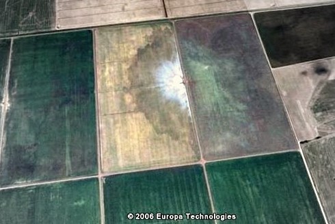
A sandblow / sandboil just west of New Madrid, from Google Earth.
Posted on 04/20/2008 10:54:25 PM PDT by kc8ukw
Magnitude 4.5 Date-Time
* Monday, April 21, 2008 at 05:38:30 UTC * Monday, April 21, 2008 at 12:38:30 AM at epicenter
Location 38.473°N, 87.823°W Depth 10 km (6.2 miles) set by location program Region ILLINOIS Distances
* 8 km (5 miles) NW (323°) from Mount Carmel, IL * 12 km (7 miles) WSW (238°) from Allendale, IL * 12 km (8 miles) NE (37°) from Bellmont, IL * 35 km (22 miles) SW (230°) from Vincennes, IN * 60 km (37 miles) NNW (337°) from Evansville, IN * 211 km (131 miles) E (94°) from St. Louis, MO
Location Uncertainty horizontal +/- 6.1 km (3.8 miles); depth fixed by location program Parameters NST= 44, Nph= 44, Dmin=37.6 km, Rmss=1.27 sec, Gp= 47°, M-type="Nuttli" surface wave magnitude (MLg), Version=7 Source
* U.S. Geological Survey, National Earthquake Information Center: World Data Center for Seismology, Denver
Event ID us2008rcar

A Tour through the New Madrid Seismic Zone
http://www.showme.net/~fkeller/quake/tour.htm#littleprairie
That’s wild. I don’t think I’ve heard of sand-blows before. I would have thought of sink-holes before I would have come up with that one. Thanks for the response and the informative link.
Very nice. I like both of those links. I’m going to have to check them out in more detail in the morning.
BTW, if a 4.0 gets things going like that, imagine a full bore New Madrid shaker. I don’t like the idea at all.
I know this is going to be a bit of a stretch, but I also have some concerns for regions in Missouri and nearby states where mining was really big over the last century.
Around Galena, Kansas and the Joplin, Missouri area the ground was honeycombed with mining. What happens when those areas get a big shaker? Is there going to be massive settling?
Thanks for that fascinating link.
My husband and I slept through the aftershock early this morning, but our daughter felt it, as she had just laid down to go to sleep.
She thought one of the cats had jumped on her bed, but when she looked, she didn’t see any of them. She heard something fall in her room, and got up and looked to see which cat was to blame. There was no cat to be found, and after being slightly freaked out for a minute or so, she went to sleep.
I guess we now know that a cat, jumping onto the bed, is approximately the same as a 4.0 quake.
The whole website is very interesting.
The main page is here...
http://showme.net/~fkeller/quake/index.htm
Earthquake lights
Earthquake lights have been seen since ancient times. 1811-12 New Madrid quake eyewitnesses saw them possibly from as far away as Savannah GA. They were first photographed in 1968 in Japan. USGS admits their existence.
Records of earthquakes that were accompanied by sky lights can be found in 373 BC in ancient Greek writings, that “immense columns of flame” foretold the earthquake that destroyed the cities of Helike and Bura.
However, even in the early 20th century they were still considered a myth, until photographs of actual lights were taken in Japan in the 1960s.
William Leigh Pierce, a traveler on the Mississippi, observed, “On the 30th of November, 1811 about one half hour before sun-rise, two vast electrical columns shot up from the eastern horizon, until their heads reached the zenith” — from Feldman book
more info here...
http://showme.net/~fkeller/quake/maps.htm#lights
That too is very interesting. Thanks for the mention. I looked at some of the photos. Kindof makes you wonder if these lights don’t precede every earthquake, but are seldom noticed.
If so, some sort warning system might ensue.
There is some “small” triangular activity going on in the last few days or so. Keep in mind that the Wabash Valley Zone (in IL/IN) has been very quiet for sometime before the Friday 4/18 4:37am central time 5.2 quake (UTC 9:37am)
I find it all very interesting even if it means nothing.
Check out these 2 pages (open each one in a new window)
(one is a location map and the other is the data for the location map)
http://earthquake.usgs.gov/eqcenter/recenteqsus/Maps/US10/32.42.-90.-80.php
http://earthquake.usgs.gov/eqcenter/recenteqsus/Maps/US10/32.42.-90.-80_eqs.php (deduct 5 hours off the UTC times to get the actual Central time)


About all I can say, is that I’m glad I’m not living in that region right now. This activity may signify nothing, and then again it may be a reawakening of the fault zone.
We just had another 4.2 quake on the same fault (Wabash Valley)
April 25, 2008
at 12:31 pm central time
http://earthquake.usgs.gov/eqcenter/recenteqsus/Maps/US10/32.42.-95.-85_eqs.php
Disclaimer: Opinions posted on Free Republic are those of the individual posters and do not necessarily represent the opinion of Free Republic or its management. All materials posted herein are protected by copyright law and the exemption for fair use of copyrighted works.