Posted on 09/01/2007 6:57:00 AM PDT by NautiNurse
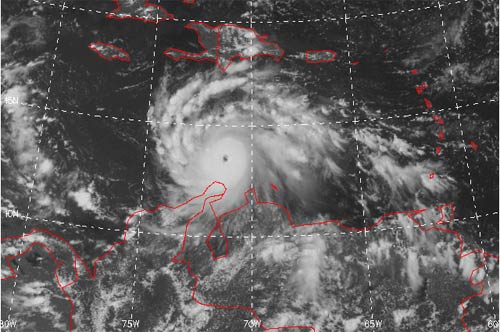
Tropical Storm Felix has formed near the South American
A tropical storm watch remains in effect for the northern coast of Venezuela from Cumana to Pedernales including the island of Margarita.
Public Advisories Updated every three hours.
Tropical Storm Discussion Updated every six hours
Storm Track Archive Nice animated progression of 5 day forecast tracks
Buoy Data East Caribbean
Buoy Data West Caribbean
Satellite Images
Additional Resources:
Central Florida Hurricane Center
Hurricane City
Cayman One Radio Nice music mix, and hourly news
| Category | Wind Speed | Barometric Pressure | Storm Surge | Damage Potential |
|---|---|---|---|---|
| Tropical Depression |
< 39 mph < 34 kts |
Minimal | ||
| Tropical Storm |
39 - 73 mph 34 - 63 kts |
Minimal | ||
| Hurricane 1 (Weak) |
74 - 95 mph 64 - 82 kts |
28.94" or more 980.02 mb or more |
4.0' - 5.0' 1.2 m - 1.5 m |
Minimal damage to vegetation |
| Hurricane 2 (Moderate) |
96 - 110 mph 83 - 95 kts |
28.50" - 28.93" 965.12 mb - 979.68 mb |
6.0' - 8.0' 1.8 m - 2.4 m |
Moderate damage to houses |
| Hurricane 3 (Strong) |
111 - 130 mph 96 - 112 kts |
27.91" - 28.49" 945.14 mb - 964.78 mb |
9.0' - 12.0' 2.7 m - 3.7 m |
Extensive damage to small buildings |
| Hurricane 4 (Very strong) |
131 - 155 mph 113 - 135 kts |
27.17" - 27.90" 920.08 mb - 944.80 mb |
13.0' - 18.0' 3.9 m - 5.5 m |
Extreme structural damage |
| Hurricane 5 (Devastating) |
Greater than 155 mph Greater than 135 kts |
Less than 27.17" Less than 920.08 mb |
Greater than 18.0' Greater than 5.5m |
Catastrophic building failures possible |

Damn, Felix grew fast. Is that common?
Could be why NHC isn't as resolved as they usually are.
recon just found 128 kts at flight level
so 115 kts surface 130 mph
update 132kts just found
so 135MPH surface winds
From tropical depression to major hurricane in less than 48 hours is an unusual event.
I was just joking yesterday when I pinged NN to the Hebert boxes but now I'm not so sure. See what 5p update is.
http://weather.hawaii.edu/satellite/satanim.cgi?chnl=uw4&domain=crb&size=large&period=720&incr=30&rr=900&satplat=goes12&overlay=off Not for Dialup
957 mb big drop
VORTEX DATA MESSAGE
A. 02/18:54:20Z
B. 13 deg 29 min N
071 deg 25 min W
C. 700 mb 2703 m
D. 95 kt
E. 268 deg 008 nm
F. 356 deg 114 kt
G. 268 deg 007 nm
H. 957 mb
I. 8 C/ 3060 m
J. 16 C/ 3050 m
K. 13 C/ NA
L. CLOSED WALL
M. C12
N. 12345/ 7
O. 0.02 / 01 nm
P. AF305 0806A FELIX OB 12
MAX FL WIND 122 KT NE QUAD 17:21:10 Z
MAX OUTBOUND FL WIND 132 KT NE QUAD 18:57:10 Z
SFC CNTR WITHIN 5NM OF FL CNTR
STADIUM EFFECT
AL06 2007
The gulf high pressure ridge is likely to keep it out of Texas, I think.
I like the way you think:’)
Tropical storm to stadium effect in 36 hours. Amazing.
After this summer, we are well on the way. ;)
I hope so, but all it has to do is jump through the Bay of Campeche to stir things up in the Gulf for a week.
bookmark
It's the MM5, a near worthless, primitive model. NHC basically ignores it. One thing to note is it is NOT the "FSU superensemble" (a completely different model, which is not public, that NHC will sometimes mention.)
Statement as of 5:00 PM EDT on September 02, 2007
...Felix continues to strengthen...now a category four hurricane...
A tropical storm watch remains in effect for Jamaica and for Grand
Cayman. A tropical storm watch means that tropical storm
conditions are possible within the watch area...generally within 36
hours.
Interests elsewhere in the central and western Caribbean Sea should
closely monitor the progress of this system.
For storm information specific to your area...including possible
inland watches and warnings...please monitor products issued
by your local weather office.
At 500 PM EDT...2100z...the center of Hurricane Felix was located
near latitude 13.6 north...longitude 72.0 west or about 440 miles...
710 km...southeast of Kingston Jamaica.
Felix is moving toward the west-northwest near 20 mph...32 km/hr...
and this general motion is expected to continue for the next 24
hours.
Reports from an Air Force hurricane hunter plane indicate that the
maximum sustained winds have increased to near 140 mph...220
km/hr...with higher gusts. Felix is a category four hurricane on
the Saffir-Simpson scale. Additional strengthening is forecast
during the next 24 hours.
Hurricane force winds extend outward up to 25 miles...35 km...from
the center...and tropical storm force winds extend outward up to 115
miles...185 km.
The minimum central pressure estimated from the aircraft data is 956
mb...28.23 inches.
Felix is expected to produce total rainfall amounts of 2 to 4 inches
over the Guajira Peninsula of northern Colombia.
Repeating the 500 PM EDT position...13.6 N...72.0 W. Movement
toward...west-northwest near 20 mph. Maximum sustained winds...140
mph. Minimum central pressure...956 mb.
An intermediate advisory will be issued by the National Hurricane
Center at 800 PM EDT followed by the next complete advisory at 1100
PM EDT.
$$
Forecaster Pasch
CAT 4 140MPH winds
no change in FORECAST TRACK
CAT 4 140MPH winds
no change in FORECAST TRACK
Movement toward...west-northwest near 20 mph.
Maximum sustained winds...140 mph.
Minimum central pressure...956 mb.
That was fast! 2.25 hours between Cat 3 and Cat 4.
Disclaimer: Opinions posted on Free Republic are those of the individual posters and do not necessarily represent the opinion of Free Republic or its management. All materials posted herein are protected by copyright law and the exemption for fair use of copyrighted works.