Skip to comments.
Hurricane Dean Live Thread [Now Cat 4]
NOAA/NWS ^
| August 16 2007
| NOAA/NWS
Posted on 08/16/2007 4:43:17 AM PDT by NautiNurse
click here to read article
Navigation: use the links below to view more comments.
first previous 1-20 ... 101-120, 121-140, 141-160 ... 1,101-1,102 next last
To: CindyDawg
We’re all good. v junior is off in the Navy now that he’s finished schrool.
121
posted on
08/16/2007 9:23:39 PM PDT
by
ventana
To: ventana
My son is in the Navy. When he first went in, he was on a tanker(?). He called me one day. He was all in awe. They were leaving port for a hurricane coming in. He was telling me that as far as he could see, ships were following him. I had to laugh. Of course they were. He was carrying the gas:’)
To: NautiNurse
Radio Martinique via translation -
The Dean hurricane which moves right on Martinique comprises gusts going until 130km/h. the authorities launched to 17 hours the red alert, it quasi totality of the communes of the island took dispostions to accomodate people in shelters. They also have each one a PC of crisis. The animation and the Drafting of Rci are mobilized and there for you to inform all the night.
125
posted on
08/16/2007 9:57:16 PM PDT
by
HAL9000
(http://LinksToNewsSources.GooglePages.com)
To: CindyDawg
To: HAL9000
127
posted on
08/16/2007 10:14:33 PM PDT
by
NautiNurse
(McClatchy News report: Half the nation's families earn below the median family income)
To: NautiNurse
128
posted on
08/16/2007 10:24:08 PM PDT
by
HAL9000
(http://LinksToNewsSources.GooglePages.com)
To: NautiNurse
129
posted on
08/16/2007 10:38:38 PM PDT
by
HAL9000
(http://LinksToNewsSources.GooglePages.com)
To: HAL9000; NautiNurse; All
Late start this year, nn ..prayers for all in harm's way. Looks like the US will be spared, please God.
~~~~~~
Tropical Storm Public Advisory
Statement as of 2:00 am AST on August 17, 2007
...Center of Dean to pass near Martinique and St. Lucia during the next few hours...
a Hurricane Warning remains in effect for St. Lucia...Martinique...Dominica...and Guadeloupe and its dependencies. Preparations to protect life and property should be very near completion.
A Tropical Storm Warning remains in effect for the U.S. Virgin Islands and Puerto Rico. A Tropical Storm Warning also remains in effect for the following islands of the Lesser Antilles...Grenada and its dependencies...St. Vincent and The Grenadines...Barbados...Saba...St. Eustatius...Montserrat...Antigua...Nevis...St Kitts... Barbuda...St. Maarten...and Anguilla.
A Tropical Storm Warning means that tropical storm conditions are expected within the warning area within the next 24 hours.
A tropical storm watch remains in effect for the South Coast of the Dominican Republic from Cabo engano to the Haiti/Dominican Republic border. A tropical storm watch means that tropical storm conditions are possible within the watch area...generally within 36 hours.
Interests in the central and western Caribbean...including Haiti...Jamaica...and the Cayman Islands...should closely monitor the progress of Dean.
For storm information specific to your area...including possible inland watches and warnings...please monitor products issued by your local weather office.
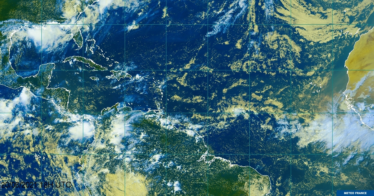
At 200 am AST...0600z...French radar data from Martinique helped locate the center of Hurricane Dean near latitude 14.3 north... longitude 59.8 west or about 85 miles...135 km...east-southeast of Martinique and about 90 miles...140 km...north-northwest of Barbados.
Dean is moving toward the west near 25 mph...41 km/hr...and this motion is expected to continue for the next 24 hours. On the forecast track...the center of Dean will be passing very near the islands of St. Lucia and Martinique within the next six hours.
Maximum sustained winds are near 100 mph...160 km/hr...with higher gusts. Dean is a category two hurricane on the Saffir-Simpson scale. Stronger winds...especially in gusts...are likely over elevated terrain near the path of the center. Some strengthening is forecast during the next 24 hours.
Hurricane force winds extend outward up to 25 miles...35 km...from the center...and tropical storm force winds extend outward up to 140 miles...220 km.
The estimated minimum central pressure is 976 mb...28.82 inches.
Storm surge flooding of 2 to 4 feet above normal tide levels... accompanied by large and dangerous battering waves...is possible near the center of Dean.
Storm total rainfall of 2 to 5 inches...with isolated maximum amounts of 10 inches in mountainous areas...are possible in association with Dean in the Lesser Antilles. Across Puerto Rico...storm total amounts of 1 to 2 inches can be expected...with maximum amounts of up to 5 inches. These rains could cause life-threatening flash floods and mudslides.
Repeating the 200 am AST position...14.3 N...59.8 W. Movement toward...west near 25 mph. Maximum sustained winds...100 mph. Minimum central pressure...976 mb.
The next advisory will be issued by the National Hurricane Center at 500 am AST.
Forecaster Beven

130
posted on
08/16/2007 11:38:15 PM PDT
by
STARWISE
(They (Rats) think of this WOT as Bush's war, not America's war-RichardMiniter, respected OBL author)
To: NautiNurse
I guess I have to stop taking vacations in August; it always seems we get a hurricane on the front pages when I get back.
Sorry.
131
posted on
08/17/2007 12:11:36 AM PDT
by
steveegg
(I am John Doe, and a monthly donor)
To: STARWISE
Hurricane Dean Public Advisory #16
Statement as of 5:00 am AST on August 17, 2007
...Center of Dean passing near St. Lucia and Martinique.
A Hurricane Warning remains in effect for St. Lucia... Martinique...
Dominica...and Guadeloupe and its dependencies.  Preparations to
protect life and property should be rushed to completion.

At 5 am AST...0900 UTC...the meteorological service of Antigua has
issued a Tropical Storm Warning for the British Virgin Islands.  A
Tropical Storm Warning remains in effect for the U.S. Virgin
Islands and Puerto Rico. A Tropical Storm Warning also remains in
effect for the following islands of the Lesser Antilles...Grenada
and its dependencies...St. Vincent and The Grenadines...Barbados...
Saba...St. Eustatius... Montserrat...Antigua...Nevis...St
Kitts...Barbuda...St. Maarten...and Anguilla.  A Tropical Storm
Warning means that tropical storm conditions are expected within
the warning area within the next 24 hours.

At 5 am AST...0900 UTC...a tropical storm watch is in effect for the
southwestern peninsula of Haiti from Port-au-Prince to the
Haiti/Dominican Republic border.  A tropical storm watch remains in
effect for the South Coast of the Dominican Republic from Cabo
engano to the Haiti/Dominican Republic border. A tropical storm
watch means that tropical storm conditions are possible within the
watch area...generally within 36 hours.

Interests elsewhere in the central and western Caribbean...including
Jamaica and the Cayman Islands...should closely monitor the progress
of Dean.

For storm information specific to your area...please monitor
products issued by your local weather office.

At 500 am AST...0900z...the center of Hurricane Dean was located
near latitude 14.3 north...longitude 60.9 west or in the St. Lucia
channel between St. Lucia and Martinique.

Dean is moving toward the west near 24 mph...39 km/hr...and this
general motion is expected to continue with some decrease in forward
speed during the next 24 hours.  This motion should take the
center of Dean away from the Lesser Antilles later today.

Maximum sustained winds are near 100 mph...160 km/hr...with higher
gusts.  Dean is a category two hurricane on the Saffir-Simpson
scale.  Stronger winds...especially in gusts...are likely
over elevated terrain near the path of the center.  Some
strengthening is forecast during the next 24 hours.

Hurricane force winds extend outward up to 25 miles...35 km...from
the center...and tropical storm force winds extend outward up to 140
miles...220 km.  Fort-de-France on Martinique recently reported a
wind gust of 59 mph...94 km/hr...while Barbados has recently
reported a wind gust of 55 mph...89 km/hr.

The estimated minimum central pressure is 976 mb...28.82 inches.

Storm surge flooding of 2 to 4 feet above normal tide levels...
accompanied by large and dangerous battering waves...is possible
near the center of Dean.

Storm total rainfall of 2 to 5 inches...with isolated maximum
amounts of 10 inches in mountainous areas...are possible in
association with Dean in the Lesser Antilles.  Across Puerto
Rico...storm total amounts of 1 to 2 inches can be expected...with
maximum amounts of up to 5 inches.  These rains could cause
life-threatening flash floods and mudslides.

Repeating the 500 am AST position...14.3 N...60.9 W.  Movement
toward...west near 24 mph.  Maximum sustained winds...100 mph.
Minimum central pressure...976 mb.

An intermediate advisory will be issued by the National Hurricane
Center at 800 am AST followed by the next complete advisory at 1100
am AST.

$$
Forecaster Beven
132
posted on
08/17/2007 1:36:45 AM PDT
by
steveegg
(I am John Doe, and a monthly donor)
To: NautiNurse
South Texas and gas pumps; we could have a problem.
Hurricane Dean Discussion Number 16
Statement as of 5:00 am EDT on August 17, 2007
The convective organization of Dean is not very impressive in either
satellite imagery or imagery from the French radar on Martinique.
There are only occasional glimpses of a ragged eye on radar...and
the eyewall has been at best about 50 percent coverage.  Satellite
intensity estimates are 77 kt from both TAFB and SAB...which are
unchanged from earlier.  The initial intensity will remain 85 kt
for this advisory...but it is possible this is a little generous.
The initial motion is 275/21.  Dean is on the south side of a
deep-layer ridge...and this should continue for the next 72 hr with
Dean remaining on a general westward to west-northwestward track.
The large-scale models have seemingly responded to the G-IV jet
mission by showing a slightly weaker ridge north of Dean...with a
motion that is slower and a little to the right of previous
forecasts.  Given the initial motion...the first 12 hr of the
forecast track will be essentially unchanged from the previous
package...with a slight nudge to the right from 12-72 hr.  After 72
hr...the forecast is becoming more problematic due to uncertainties
in the eventual interaction of Dean and the upper-level low
forecast to be over the Gulf of Mexico.  The GFDL and UKMET models
now call for Dean to turn northwestward into the central
Gulf...while the Canadian...NOGAPS...and European models continue
to forecast a westward motion across the Yucatan Peninsula into the
Bay of Campeche.  The GFS and the various consensus models are
between these two extremes.  The forecast track after 72 hr is also
nudged a little to the right in agreement with the consensus
guidance.

The development of Dean has apparently been slowed by a combination
of dry air intrusion in the western semicircle and light westerly
shear.  These conditions may persist for another 12-24 hr...so the
intensity forecast calls for slow strengthening during this time.
After 24 hr...conditions should be favorable for significant
strengthening...with most of the intensity guidance calling for
Dean to reach at least category 4 strength.  The intensity forecast
is the same as in the earlier advisory through 72 hr...then
slightly stronger thereafter.  It should be noted that the
weakening from 96 to 120 hr is based on Dean crossing the Yucatan
Peninsula...and if it instead moves through the Yucatan Channel it
could remain stronger.

Forecast positions and Max winds

initial      17/0900z 14.3n  60.9w    85 kt
 12hr VT     17/1800z 14.7n  63.6w    90 kt
 24hr VT     18/0600z 15.3n  67.0w    95 kt
 36hr VT     18/1800z 16.1n  70.5w   105 kt
 48hr VT     19/0600z 16.9n  74.0w   115 kt
 72hr VT     20/0600z 18.5n  81.0w   120 kt
 96hr VT     21/0600z 20.5n  87.0w   125 kt
120hr VT     22/0600z 23.0n  92.0w    95 kt

$$
forecaster Beven
133
posted on
08/17/2007 1:58:13 AM PDT
by
steveegg
(I am John Doe, and a monthly donor)
To: steveegg
Please, no more “nudges to the right”!
134
posted on
08/17/2007 2:25:58 AM PDT
by
Timeout
(I hate MediaCrats! ......and trial lawyers.)
To: Timeout
Please, no more “nudges to the right”! Unless it is a rather hard right and a stall over Cuba ;-)
135
posted on
08/17/2007 2:33:32 AM PDT
by
steveegg
(I am John Doe, and a monthly donor)
To: steveegg
Things could get quite interesting by this time next week for those of us on the Texas gulf coast.
136
posted on
08/17/2007 2:36:49 AM PDT
by
eastforker
(.308 SOCOM 16, hottest brand going.2350 FPS muzzle..M.. velocity)
To: steveegg; NautiNurse; All
Coastal Watches/Warnings and 5-Day Track Forecast Cone

137
posted on
08/17/2007 3:19:59 AM PDT
by
Clive
To: Clive
Looks like I gotta go stock up on gas for the generator this weekend before the prices go outa sight.
138
posted on
08/17/2007 3:28:20 AM PDT
by
eastforker
(.308 SOCOM 16, hottest brand going.2350 FPS muzzle..M.. velocity)
To: steveegg
The large-scale models have seemingly responded to the G-IV jet mission by showing a slightly weaker ridge north of Dean...with a motion that is slower and a little to the right of previous forecasts.Not good.
The development of Dean has apparently been slowed by a combination of dry air intrusion in the western semicircle and light westerly shear. These conditions may persist for another 12-24 hr...so the intensity forecast calls for slow strengthening during this time.
Dean is already looking like the dry air's impact is lessening.
139
posted on
08/17/2007 4:50:15 AM PDT
by
dirtboy
(Impeach Chertoff and Gonzales. We can't wait until 2009 for them to be gone.)
To: dirtboy
I’m in Puerto Rico right now... returning to Baltimore tonight... Dean will be a big rainmaker in PR tomorrow and Sunday, but the biggest concern of the people here is that Dean takes a northwardly last-minute turn and strikes the island head-on, just like Hugo in ‘89 and Georges in ‘98...
140
posted on
08/17/2007 5:31:55 AM PDT
by
SilvieWaldorfMD
(I'm Puerto Rican, but I ain't no "Welfare Queen"!)
Navigation: use the links below to view more comments.
first previous 1-20 ... 101-120, 121-140, 141-160 ... 1,101-1,102 next last
Disclaimer:
Opinions posted on Free Republic are those of the individual
posters and do not necessarily represent the opinion of Free Republic or its
management. All materials posted herein are protected by copyright law and the
exemption for fair use of copyrighted works.
FreeRepublic.com is powered by software copyright 2000-2008 John Robinson