| This thread has been locked, it will not receive new replies. |
|
Locked on 10/24/2005 2:24:18 AM PDT by Jim Robinson, reason:
New thread: http://www.freerepublic.com/focus/news/1508056/posts |
Posted on 10/22/2005 1:25:10 PM PDT by NautiNurse
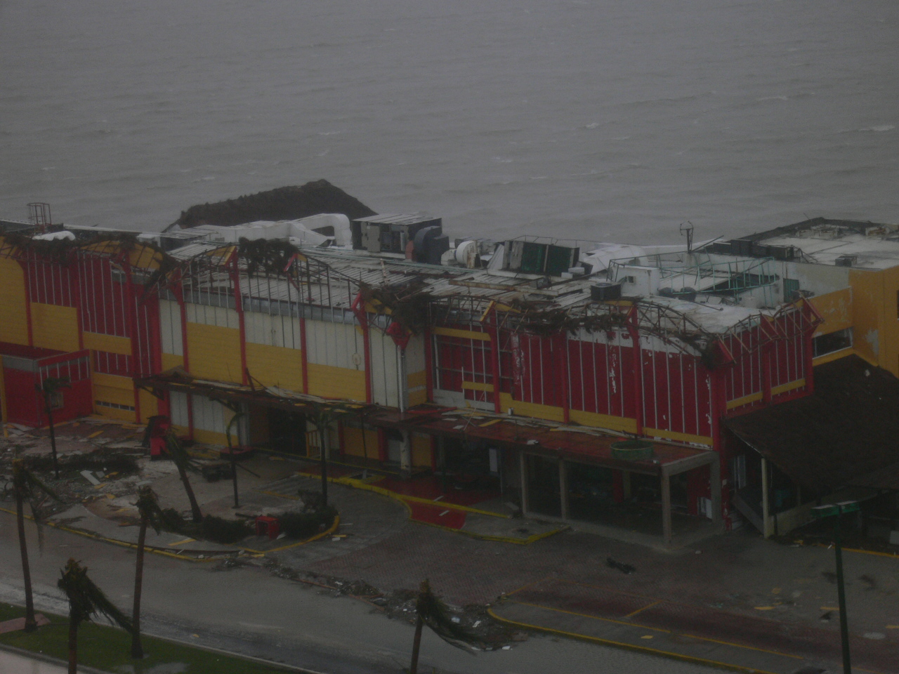
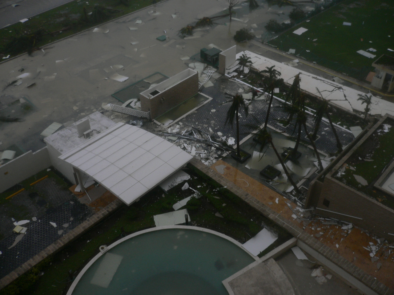
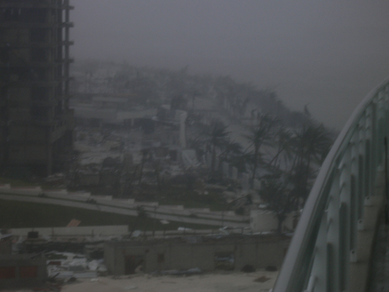
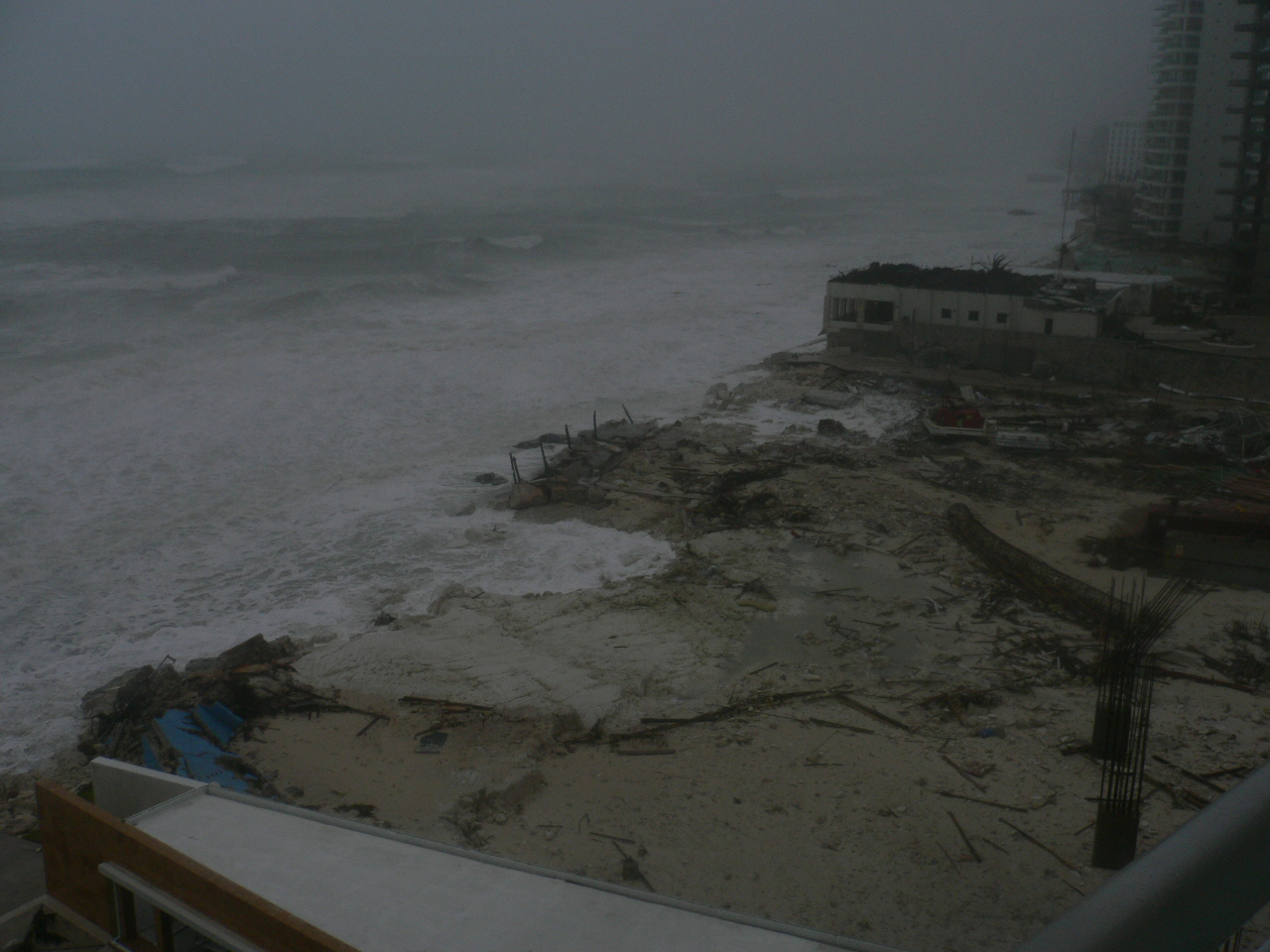
Hurricane Wilma slowly drifts toward the Southeast Gulf of Mexico after relentlessly pounding Cozumel and Cancun for more than 24 hours. Early reports indicate extensive wind and flood damage to Mexico's resort-studded Mayan Riviera. Mexican officials said about 20,000 tourists were at shelters and hotels on the mainland south of Cancun and an estimated 10,000-12,000 were in Cancun itself. About 50 hotels were evacuated.
In preparation for Hurricane Wilma's anticipated Florida landfall, a Hurricane Watch and mandatory evacuation have been issued for the Florida Keys and Florida Bay. Mandatory evacuations for Marco Island and much of Naples are in effect, as well as high surf advisories and high risk of rip currents along Florida's panhandle and Big Bend coasts. Bus services are available for Monroe Co. and other counties for residents who do not have transportation. Additional storm watches for the Florida peninsula are expected later today.
The 2005 hurricane season altered the record books again today with the formation of Tropical Storm Alpha south of Hispanola. Preliminary forecasts indicate TS Alpha will not affect the U.S. mainland.
The following links are self-updating:
Public Advisory Currently published every 3 hours 0500, 0800, 1100 etc. ET
NHC Discussion Published every six hours 0500, 1100, 1700, 2300 ET
Three Day Forecast Track
Five Day Forecast Track
Wilma Forecast Track Archive
Forecast Models
Buoy Data SE Florida
Current Weather Warnings and Watches for Florida
Florida Department of Emergency Management
Images:
Storm Floater IR Loop
Visible Storm Floater Still (only visible during daylight hours)
Color Enhanced Atlantic Loop
Florida Radar/Sat Loop Caution: Broadband users only
Extra Large Miami Radar Broadband only
Extra Large Key West Radar Broadband only
Miami Long Range Radar Loop
Key West Long Range Radar Loop
Miami Experimental Radar Still Image
Key West Experimental Radar Still Image
Streaming Video:
WBBH-TV/WZVN-TV Ft. Myers (WMP): http://waterbc.wm.llnwd.net/waterbc_netvideo
WESH-TV/DT Orlando/Daytona Beach (RP): http://mfile.akamai.com/7883/live/reflector:24028.ram
WFTV-TV/DT Orlando (RP): http://mfile.akamai.com/7883/live/reflector:20361.ram
WKMG-TV/DT Orlando (RP): http://mfile.akamai.com/7883/live/reflector:23942.ram
WPBF-TV/DT West Palm Beach (RP): http://mfile.akamai.com/7883/live/reflector:24035.ram
WSVN-TV/DT Miami (WMP): http://216.242.118.140/windowsmedia/asx/wsvn_broadband.asx
WTVJ-TV/DT Miami: http://nbc6.feedroom.com/iframeset.jsp?ord=381015
WPLG-TV/DT Miami (RP): http://mfile.akamai.com/8660/live/reflector:23941.ram
WFOR-TV/DT Miami (WMP): http://wfor.dayport.com/viewer/content/special.php?Art_ID=612&Format_ID=2&BitRate_ID=8&Contract_ID=2&Obj_ID={obj_id}
WTSP-TV/DT St. Petersburg/Tampa (WMP): mms://wmbcast.gannett.speedera.net/wmbcast.gannett/wmbcast_gannett_sep252004_1915_64623
Hurricane City (Real Player) - http://hurricanecity.com/live.ram
ABCNews Now (Real Player) - http://reallive.stream.aol.com/ramgen/redundant/abc/now_hi.rm
Additional Resources:
Pet Friendly Florida Shelter Info
Central Florida Hurricane Center
Hurricane City
CrownWeather.com
| Category | Wind Speed | Barometric Pressure | Storm Surge | Damage Potential |
|---|---|---|---|---|
| Tropical Depression |
< 39 mph < 34 kts |
Minimal | ||
| Tropical Storm |
39 - 73 mph 34 - 63 kts |
Minimal | ||
| Hurricane 1 (Weak) |
74 - 95 mph 64 - 82 kts |
28.94" or more 980.02 mb or more |
4.0' - 5.0' 1.2 m - 1.5 m |
Minimal damage to vegetation |
| Hurricane 2 (Moderate) |
96 - 110 mph 83 - 95 kts |
28.50" - 28.93" 965.12 mb - 979.68 mb |
6.0' - 8.0' 1.8 m - 2.4 m |
Moderate damage to houses |
| Hurricane 3 (Strong) |
111 - 130 mph 96 - 112 kts |
27.91" - 28.49" 945.14 mb - 964.78 mb |
9.0' - 12.0' 2.7 m - 3.7 m |
Extensive damage to small buildings |
| Hurricane 4 (Very strong) |
131 - 155 mph 113 - 135 kts |
27.17" - 27.90" 920.08 mb - 944.80 mb |
13.0' - 18.0' 3.9 m - 5.5 m |
Extreme structural damage |
| Hurricane 5 (Devastating) |
Greater than 155 mph Greater than 135 kts |
Less than 27.17" Less than 920.08 mb |
Greater than 18.0' Greater than 5.5m |
Catastrophic building failures possible |
Previous Threads:
Hurricane Wilma Part II
Hurricane Wilma Live Thread
Tropical Storm Wilma
Tropical Depression #24
Thanks.
Thanks for adding me to your list. I'm already wondering what's going to happen to the Taunton dam...
Whew.
...Wilma moving a little faster northeastward but not yet
strengthening...
...New warnings for the northwestern Bahamas...
a Hurricane Warning remains in effect for all of the Florida
Keys...including the Dry Tortugas and Florida Bay...along the
Florida West Coast from Longboat Key southward...and along the
Florida East Coast from Titusville southward...including Lake
Okeechobee.
A Tropical Storm Warning remains in effect along the Florida West
Coast north of Longboat Key to Steinhatchee river...and along the
Florida East Coast north of Titusville to Flagler Beach.
A tropical storm watch remains in effect along the East Coast of
Florida from north of Flagler Beach to Fernandina Beach.
A Hurricane Warning remains in effect from San Felipe to Punta
gruesa on the Yucatan Peninsula...including Cozumel and the nearby
islands...and a Tropical Storm Warning remains in effect west of
San Felipe to Progreso.
A Hurricane Warning remains in effect for the Cuban provinces of
Ciudad de la Habana...la Habana...and Pinar del Rio.  A Tropical
Storm Warning is in effect for the Isle of Youth.  A Hurricane
Watch remains in effect for the province of Matanzas.
At 8 am EDT...1200z...the government of the Bahamas has issued a
Hurricane Warning for the northwestern Bahamas...including the
Abacos...Andros Island...Berry Islands...Bimini...Eleuthera...Grand
Bahama Island...and New Providence.
For storm information specific to your area...including possible
inland watches and warnings...please monitor products issued
by your local weather office.
At 7 am CDT...1200z...the center of Hurricane Wilma was located near
latitude 22.4 north... longitude 86.1 west or about 90 miles... 145
km... north-northeast of Cancun Mexico and about 315 miles... 505
km... west-southwest of Key West Florida.
Wilma is moving toward the northeast near 8 mph...13 km/hr...and an
increase in forward speed is expected during the next 24 hours.
Maximum sustained winds are near 100 mph...160 km/hr...with higher
gusts.  Wilma is a category two hurricane on the Saffir-Simpson
scale.  Some increase in strength is possible today.
Hurricane force winds extend outward up to 70 miles...110 km...
from the center...and tropical storm force winds extend outward up
to 200 miles...325 km.  NOAA buoy 42056...located in the
northwestern Caribbean Sea about 185 miles... 295 km...
south-southeast of the center of Wilma recently reported sustained
tropical storm force winds of 47 mph... 76 km/hr.
An Air Force hurricane hunter aircraft recently measured a minimum
central pressure of 961 mb...28.38 inches.
Storm surge flooding of 8 to 13 ft above normal tide levels is
possible along the southwest Florida coast near and to the
south of where the center of Wilma makes landfall.  Storm surge
flooding of 5 to 8 ft above normal is possible in the Florida Keys
and Florida Bay...as well as in Lake Okeechobee.  Storm surge
flooding along the Yucatan Peninsula and the nearby islands should
subside as Wilma moves away.
Wilma is expected to produce additional rainfall accumulations of 10
to 15 inches through Sunday across portions of western Cuba and the
northeastern Yucatan Peninsula... with isolated maximum storm total
amounts approaching 50 inches.  Rainfall across southern Florida
including the Keys through Tuesday is expected to be 4 to 8
inches... with isolated maximum amounts of 12 inches possible.
Large swells generated by Wilma will continue to propagate into the
eastern Gulf of Mexico.  These swells could affect portions of the
northern Gulf Coast today.
Isolated tornadoes are possible over the southern Florida Peninsula
and the Florida Keys today.
Repeating the 7 am CDT position...22.4 N... 86.1 W.  Movement
toward...northeast near 8 mph.  Maximum sustained winds...100 mph.
Minimum central pressure... 961 mb.
The next advisory will be issued by the National Hurricane Center at
10 am CDT.
Forecaster Knabb
You and me both. I live up here in Maine, and all last week-end, I watched it on Fox News. There are over 2,000 living and working below that dam. It would be horrifying if that old dam broke, and that's for sure.
I find it funny that America's hurricane agency would issue watches and warnings for FR's supposedly sworn enemy, Cuba.
ff
There are people of Cuban descent on FR who are concerned for their loved ones.
They've been building a new dam this week- and will be tearing down the old one. They hope to have it completed by the time Wilma/Alpha rains arrive.
They don't...the government of the Bahamas has issued a Hurricane Warning for the northwestern Bahamas. The Cuban warnings were already in effect.
Bits and pieces from CHN message board:
UPDATE FROM COZUMEL,
7:30pm, Saturday
Adrian (shown at left) just phoned us. They have only been able to walk around downtown. The small piers for dive boats are destroyed. Punta Langosta cruise ship pier near downtown is partially destroyed. The roofs of Casa Denis restaurant and Plaza del Sol shopping area are gone. The giant flag pole is gone. he talked with the owner of Rock 'n Java restaurant and the building is intact, but all contents destroyed, as is the case with most oceanfront businesses. Almost every palapa structure has disappeared. It sounds like McDonalds has been destroyed. The expensive oceanfront shops were severely damaged or destroyed and are being looted. They found a dead body on the oceanfront, but thought that this person had been dead for several days--and was washed up by the hurricane (Do not panick, we do not think there was loss of life in Cozumel). The oceanfront street on ! the west side of downtown is intact--the seawall held. Most concrete structures are intact, but received water damage. Flooding was not a major problem in downtown, although rain was forced into every crack, so many homes received some water damage.
Scuba Tony and Encarna who we lost contact with yesterday are also fine. It is dark in Cozumel now, and they won't be going back out until mo rning. We hope to bring you further updates.
http://www.stormcarib.com/reports/2005/jpgWhJ7UKAT74.jpg
http://www.stormcarib.com/reports/2005/jpgbQabfGuuOM.jpg
http://www.stormcarib.com/reports/2005/jpgMl0FPUf5g8.jpg
http://www.stormcarib.com/reports/2005/jpgeMMzaqEsxa.jpg
http://www.stormcarib.com/reports/2005/jpgCJJGEjZFaS.jpg
The NHC merely collates the foreign watches/warnings.
Quickly reviewing the other storm, according to the 8 am intermediate advisory for TS Algore, it has just made landfall, and "is expected to weaken rapidly and could dissipate over the mountainous terrain of Hispaniola."
Thanks for the Cozumel report. The pics are amazing. I heard their goal is to have everything ready for tourists by Christmas.
The mountains of Hispanola are tough on tropical storms.
Unfortunately, no luck yet. I will be calling them in a few minutes, and I plan to tell them that it may be the last time I ever speak to them. Going for the shock factor. If that doesn't work, I will try to get ahold of the police down there.
If Wilma and Alpha were to converge, the only thing I can think of is Bam Bam on the East Coast.
I 'heard' that! A rock dam? I can't imagine how they are doing it.
Plus, they have big pumps that they are pumping water out with. I keep a close eye on Taunton. It would be a nightmare to be living under that threat day after day.
Thanks for the pics and info.
How can you even think of keeping up with a hurricane when they are showing the fat guy on the ladder on CNN? It's too exciting!
Oops, that should read CNBC, not CNN.
Disclaimer: Opinions posted on Free Republic are those of the individual posters and do not necessarily represent the opinion of Free Republic or its management. All materials posted herein are protected by copyright law and the exemption for fair use of copyrighted works.