| This thread has been locked, it will not receive new replies. |
|
Locked on 09/24/2005 10:02:57 AM PDT by Admin Moderator, reason:
Thread VIII: http://www.freerepublic.com/focus/f-news/1490587/posts |
Posted on 09/23/2005 8:01:35 PM PDT by NautiNurse
Hurricane Rita landfall is anticipated within the next few hours. Strong winds and heavy rains are battering southern Louisiana and southeastern Texas.
MSM news crews are shouting over the howling winds as they foolishly describe blowing rain, swaying trees, and crashing waves through rain splattered camera lenses. It's a hurricane. We know these things already.
An 18 wheeler rig reportedly overturned on an I-10 bridge. The fate of the truck driver is unknown at this time. Reports of widespread power outages in Lake Charles. KPLC-TV Lake Charles local news has remarkably improvised their reporting from a remote location. They are taking calls from residents, NWS, and public utility representatives, and alerting residents to local conditions.
On the flip side, CNN announced to the world that law enforcement officers had evacuated from Port Arthur TX with the rest of the population. Engraved looter invitations would have been more elegant.
Godspeed to all those in the path of this storm.
The following links are self-updating:
Public Advisory Currently published every 3 hours 5A, 8A, 11A, 2P, etc. ET
NHC Discussion Published every six hours 6A, 11A, 6P, 11P
Three Day Forecast Track
Five Day Forecast Track
Rita Forecast Track Archive
Forecast Models
Buoy Data Western Gulf of Mexico
Houston/Galveston/Beaumont/Lake Charles Wx Watches/Warnings
Jefferson Co TX NWS Weather
Current Weather Warnings and Watches for Texas
Current Weather Warnings and Watches for Louisiana
Hi Res Houston Flood Zone Map Slow load, great detail
Images:
Lake Charles Long Range Radar Still image, with loop link
Houston/Galveston Long Range Radar Still image, with loop link
Lake Charles Experimental Radar Outages and Delays May Occur
Storm Floater IR Loop
GOM WV Loop
GOM IR Still Image
Visible Storm Floater Still (only visible during daylight hours)
Color Enhanced Atlantic Loop
Streaming Video: (coverage may be intermittent)
KHOU-TV/DT Houston
KPRC-TV/DT Houston
KTRK-TV/DT Houston
KTRH-AM Houston
KPLC-TV/DT Lake Charles/Lafayette
KSLA-TV/DT Shreveport
Additional Resources:
FReeper Sign In Thread Check in to let us know whether you are staying, going, and when you get there
FReepers Offering Lodging To Rita Evacuees People and/or Pet Friendly FReepers Offering Shelter
KHOU Houston
KTRK ABC News Houston
KPLC Lake Charles Evac Routes, news
KFDM Beaumont/Port Arthur News, evac info
Hurricane City
Wxnation Houston
Galveston Webcams
Golden Triangle Weather Page Provides Galveston Weather, Warnings, Radar, etc.
| Category | Wind Speed | Barometric Pressure | Storm Surge | Damage Potential |
|---|---|---|---|---|
| Tropical Depression |
< 39 mph < 34 kts |
Minimal | ||
| Tropical Storm |
39 - 73 mph 34 - 63 kts |
Minimal | ||
| Hurricane 1 (Weak) |
74 - 95 mph 64 - 82 kts |
28.94" or more 980.02 mb or more |
4.0' - 5.0' 1.2 m - 1.5 m |
Minimal damage to vegetation |
| Hurricane 2 (Moderate) |
96 - 110 mph 83 - 95 kts |
28.50" - 28.93" 965.12 mb - 979.68 mb |
6.0' - 8.0' 1.8 m - 2.4 m |
Moderate damage to houses |
| Hurricane 3 (Strong) |
111 - 130 mph 96 - 112 kts |
27.91" - 28.49" 945.14 mb - 964.78 mb |
9.0' - 12.0' 2.7 m - 3.7 m |
Extensive damage to small buildings |
| Hurricane 4 (Very strong) |
131 - 155 mph 113 - 135 kts |
27.17" - 27.90" 920.08 mb - 944.80 mb |
13.0' - 18.0' 3.9 m - 5.5 m |
Extreme structural damage |
| Hurricane 5 (Devastating) |
Greater than 155 mph Greater than 135 kts |
Less than 27.17" Less than 920.08 mb |
Greater than 18.0' Greater than 5.5m |
Catastrophic building failures possible |
Previous Threads:
Hurricane Rita Live Thread, Part VI
Hurricane Rita Live Thread, Part V
Hurricane Rita Live Thread, Part IV
Hurricane Rita Live Thread, Part III
Hurricane Rita Live Thread, Part II
Hurricane Rita Live Thread, Part I
Tropical Storm Rita
Tropical Depression 18
Great link, Jeffers. Thanks. That's a very nasty looking storm.
I second that. Looks like she went through the most dense concentration of rigs.
What that says to me, is that it's past time to start drilling off the coast of FL.
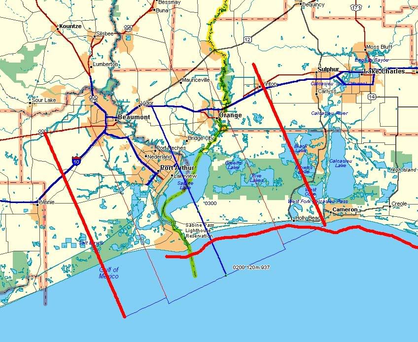
Ok, it's up, accurate but quick and dirty, no legends.
Blue = course track (which will probably curve soon)
Heavy/red/straight lines = outer eyewall
Light red straight = inner eyewall
Heavy red wavy = max surge
http://i4.photobucket.com/albums/y138/jeffers_mz/Rita/o4landfallmap.jpg
Humpty Dumpty?
Map of estimated landfall area (courtesy conservative in nyc)
First post-landfall vortex data report, eye fix 25 minutes after landfall
Good stuff...you fading?
Buoy SRST2 (Sabine, TX), 9-23/24-2005
09 24 2:00 am N 71 86 - - - - 28.23 -0.63 74.5 - - - - -
09 24 1:00 am N 63 79 - - - - 28.46 -0.56 74.1 - - - - -
09 24 12:00 am N 63 78 - - - - 28.64 -0.46 73.6 - - - - -
09 23 11:00 pm N 61 72 - - - - 28.87 -0.33 73.4 - - - - -
09 23 10:00 pm N 54 66 - - - - 29.03 -0.25 73.8 - - - - -
09 23 9:00 pm N 48 61 - - - - 29.10 -0.24 73.8 - - - - -
09 23 8:00 pm N 48 60 - - - - 29.20 -0.21 73.9 - - - - -
09 23 7:00 pm N 42 52 - - - - 29.27 -0.19 73.9 - - - - -
09 23 6:00 pm N 40 50 - - - - 29.34 -0.17 74.7 - - - - -
09 23 5:00 pm N 33 43 - - - - 29.41 -0.14 74.7 - - - - -
09 23 4:00 pm N 37 47 - - - - 29.47 -0.14 75.2 - - - - -
09 23 3:00 pm N 28 36 - - - - 29.52 -0.12 77.4 - - - - -
09 23 2:00 pm N 25 34 - - - - 29.55 -0.11 81.1
Buoy Station SRST2 - Sabine, TX
29.67 N 94.05 W (29°40'12" N 94°03'00" W)
Conditions at SRST2 as of
(3:00 am CDT)
0800 GMT on 09/24/2005
Wind Direction (WDIR): NNW ( 330 deg true )
Wind Speed (WSPD): 65 kts
Wind Gust (GST): 78 kts
Atmospheric Pressure (PRES): 28.09 in
Pressure Tendency (PTDY): -0.55 in ( Falling Rapidly )
Air Temperature (ATMP): 73.8 °F
Take a look at the first chart:
http://hurricane.methaz.org/hurapak/AAL182005_gomex_oil.html
lol
...Sat at the screen...
I'm trying to stick for the 4 am updates. I should just make it.
...Rita moves onshore near Sabine Pass as a dangerous category three
hurricane...currently near Port Arthur Texas...
a Hurricane Warning remains in effect from Sargent Texas to Morgan
City Louisiana.  A Hurricane Warning means that hurricane
conditions are expected within the warning area within the next 24
hours.  Preparations to protect life and property should have
already been completed.
At 4 am CDT...0900z...the Tropical Storm Warning is discontinued
south of Port O'Connor Texas.  A Tropical Storm Warning remains in
effect for the southeastern coast of Louisiana east of Morgan City
to the mouth of the Pearl River... including metropolitan New
Orleans and Lake Pontchartrain...and from south of Sargent Texas to
Port O'Connor Texas.  A Tropical Storm Warning means that tropical
storm conditions are expected within the warning area within the
next 24 hours.
For storm information specific to your area...including possible
inland watches and warnings...please monitor products issued
by your local weather office.
At 4 am CDT...0900z...the center of Hurricane Rita was located near
latitude 29.9 north...longitude  93.9 west or near Port Arthur
Texas.
Rita is moving toward the northwest near 12 mph.  A gradual turn
toward the north and a decrease in forward motion is expected
during the next 24 hours.  This motion should bring the center of
Rita farther inland over southeastern Texas today.
Reports from Air Force Reserve hurricane hunter aircraft and
National Weather Service Doppler radars indicate that maximum
sustained winds are near 120 mph...with higher gusts.  This makes
Rita a category three hurricane on the Saffir-Simpson scale.  Rita
should weaken today as the center moves farther inland.
Hurricane force winds extend outward up to  85 miles from the
center...and tropical storm force winds extend outward up
to 205 miles.  An instrumented tower in Port Arthur run by the
Florida coastal monitoring program has just reported sustained
winds of 91 mph with a gust to 116 mph.
The minimum central pressure measured by the hurricane hunters just
before landfall was  937 mb...27.67 inches.  The automated station
at sea rim State Park Texas recently reported a pressure of
951.3 mb...28.09 inches.
Coastal storm surge flooding of 15 feet above normal tide levels...
locally up to 20 feet at head of bays and nearby rivers...with
large and dangerous battering waves...can be expected near and to
the east of where the center makes landfall.  Tides along the
southeast Louisiana and Mississippi coasts in areas affected by
Katrina could be 4 to 6 feet above normal and be accompanied by
large waves... and residents there could experience coastal
flooding.  Large swells generated by Rita will likely affect most
portions of the Gulf Coast.
Since Rita is movingly slowly and is forecast to slow down further
over the next few days...rainfall totals of 10 to 15 inches are
expected over eastern Texas and western Louisiana.  Maximum
rainfall totals in excess of 25 inches may occur over localized
areas.  Rainfall amounts of 3 to 5 inches with isolated heavier
amounts are possible over southeastern Louisiana including
metropolitan New Orleans.
Isolated tornadoes are possible today and tonight over far eastern
Texas...Louisiana...southern Arkansas...and Mississippi.
Repeating the 4 am CDT position...29.9 N... 93.9 W.  Movement
toward...northwest near 12 mph.  Maximum sustained
winds...120 mph.  Minimum central pressure... 937 mb.
An intermediate advisory will be issued by the National
Hurricane Center at 7 am CDT followed by the next
complete advisory at 10 am CDT.
Forecaster Beven
$$
and CA and AK, WY, UT, and develop tar sands in Utah, abandon the Clinton land grab of the Utah Kaipirowitz plateau (the largest deposit of clean burn coal in the US) - also known as Grand Staircase - locked up for Indonesian campaign favors.
Did someone say energy policy? National security?
Naw, I just expect a tax hike, for me and my children's children. We deserve the government we elected.
Don't mind me. I'm just a despondent petroleum engineer.
a Hurricane Warning remains in effect from Sargent Texas to Morgan
City Louisiana.  A Hurricane Warning means that hurricane
conditions are expected within the warning area within the next 24
hours.  Preparations to protect life and property should have
already been completed.

At 4 am CDT...0900z...the Tropical Storm Warning is discontinued
south of Port O'Connor Texas.  A Tropical Storm Warning remains in
effect for the southeastern coast of Louisiana east of Morgan City
to the mouth of the Pearl River... including metropolitan New
Orleans and Lake Pontchartrain...and from south of Sargent Texas to
Port O'Connor Texas.  A Tropical Storm Warning means that tropical
storm conditions are expected within the warning area within the
next 24 hours.

Hurricane center located near 29.9n  93.9w at 24/0900z
position accurate within  15 nm

present movement toward the northwest or 325 degrees at  10 kt

estimated minimum central pressure  937 mb
eye diameter  25 nm
Max sustained winds 105 kt with gusts to 130 kt.
64 kt....... 75ne  60se  40sw  60nw.
50 kt.......120ne 100se  80sw  90nw.
34 kt.......180ne 150se 120sw 120nw.
12 ft seas..375ne 300se 275sw   0nw.
Winds and seas vary greatly in each quadrant.  Radii in nautical
miles are the largest radii expected anywhere in that quadrant.

Repeat...center located near 29.9n  93.9w at 24/0900z
at 24/0600z center was located near 29.4n  93.5w

forecast valid 24/1800z 30.9n  94.3w...inland
Max wind  70 kt...gusts  85 kt.
64 kt... 25ne  25se   0sw  25nw.
50 kt... 50ne  50se  25sw  50nw.
34 kt...100ne 120se  90sw 100nw.

Forecast valid 25/0600z 32.3n  94.5w...inland
Max wind  40 kt...gusts  50 kt.
34 kt... 75ne  75se  30sw  60nw.

Forecast valid 25/1800z 33.0n  94.0w...inland
Max wind  30 kt...gusts  40 kt.

Forecast valid 26/0600z 33.5n  93.5w...inland
Max wind  25 kt...gusts  35 kt.

Forecast valid 27/0600z 33.5n  93.5w...inland
Max wind  25 kt...gusts  35 kt.

Extended outlook. Note...errors for track have averaged near 250 nm
on day 4 and 325 nm on day 5...and for intensity near 20 kt each day

outlook valid 28/0600z 33.5n  93.5w...inland
Max wind  25 kt...gusts  35 kt.

Outlook valid 29/0600z 33.5n  93.5w...dissipating
Max wind  25 kt...gusts  35 kt.

Request for 3 hourly ship reports within 300 miles of 29.9n  93.9w

next advisory at 24/1500z

forecaster Beven


$$
six hours of rack did me right...I feel like superman ad have a quart of coffee right beside me...
lol, we are getting a flash flood warning right now...well a few counties south of me...in INDIANA...how big does a hurricane have to be to do THAT?
Answer:
http://www.ssec.wisc.edu/data/east/latest_eastwv.jpg
AREA FORECAST DISCUSSION
NATIONAL WEATHER SERVICE LAKE CHARLES LA
300 AM CDT SAT SEP 24 2005
DISCUSSION
FIRST EXPERIENCE IN A HURRICANE FOR THIS ILLINOIS BOY. PARTICULARLY MISSING HOME RIGHT NOW. SOUNDS AS IF A 747 IS SITTING UPON THE ROOF REVVING ITS ENGINES. WIND EQUIPMENT HAS FAILED HERE BUT BELIEVE WE ARE NOW SEEING WINDS POSSIBLY IN A 70 TO 90 KNOT RANGE HERE AT LAKE CHARLES. NOS GAUGE AT CALCASIEU PASS REPORTED A GUST TO 112 MPH...AND THEN FAILED. ANTICIPATING A 15 TO 20 FOOT STORM SURGE AND UNSURE AT THIS TIME IF THIS WILL IMPACT US. WAS JUST INFORMED THAT AIRPORT TERMINAL NEXT TO OFFICE HAS COLLAPSED. JUST HAD A BRIEF COMMS FAILURE BUT NOW BACK UP. UNFORTUNATELY...SINCE WE ARE NOW IN A DIAL BACKUP MODE...WILL BE UNABLE TO UPDATE GRIDS AND WILL TURN THIS RESPONSIBILITY OVER TO OUR CURRENT BACKUP OFFICE SAN ANTONIO. WE WILL MAINTAIN SHORT-TERM RESPONSIBILITY...NOWCASTS...HLS'S...TAFS...WARNINGS...AS LONG AS WE HOLD TOGETHER.
RITA CURRENTLY MOVING ONSHORE OVER EXTREME SOUTHWEST CAMERON PARISH ON A NORTH NORTHWEST TRACK...AND RIGHT ON WITH NHC FORECAST TRACK. SYSTEM PROGGED TO CONTINUE GENERAL MOTION ACROSS SOUTHEAST TEXAS TODAY WITH DAMAGING WINDS AND TORRENTIAL RAINS.
INPORTANT TO NOTE THAT LATEST MODELS INDICATING SYSTEM WILL NOT STALL ACROSS REGION...THUS WILL SEE SIGNIFICANTLY LOWER RAINFALL TOTALS GOING INTO THE NEW WEEK. JUST A BIT OF GOOD NEWS TO END ON.
Disclaimer: Opinions posted on Free Republic are those of the individual posters and do not necessarily represent the opinion of Free Republic or its management. All materials posted herein are protected by copyright law and the exemption for fair use of copyrighted works.