
not today
| This thread has been locked, it will not receive new replies. |
|
Locked on 09/23/2005 8:02:43 PM PDT by Admin Moderator, reason:
New Thread: http://www.freerepublic.com/focus/f-news/1490378/posts |
Posted on 09/23/2005 9:39:06 AM PDT by NautiNurse
Dangerous Hurricane Rita is expected to make landfall in the northeast Gulf of Mexico within 24 hours. Tornados have spawned in Louisiana. Water is filling the Ninth Ward of New Orleans again. A bus carrying elderly evacuees was gutted by fire this morning outside Dallas, with multiple fatalities. Television crews have positioned their hurricane reporters throughout the region to attain maximum drama effects. Whoooooa.
The following links are self-updating:
Public Advisory Currently published every 3 hours 5A, 8A, 11A, 2P, etc. ET
NHC Discussion Published every six hours 6A, 11A, 6P, 11P
Three Day Forecast Track
Five Day Forecast Track
Rita Forecast Track Archive
Forecast Models
Buoy Data Western Gulf of Mexico
Houston/Galveston/Beaumont/Lake Charles Wx Watches/Warnings
Jefferson Co TX NWS Weather
Current Weather Warnings and Watches for Texas
Current Weather Warnings and Watches for Louisiana
Hi Res Houston Flood Zone Map Slow load, great detail
Images:
Lake Charles Long Range Radar Still image, with loop link
Houston/Galveston Long Range Radar Still image, with loop link
Lake Charles Experimental Radar Outages and Delays May Occur
Storm Floater IR Loop
GOM WV Loop
GOM IR Still Image
Visible Storm Floater Still (only visible during daylight hours)
Color Enhanced Atlantic Loop
Streaming Video: (coverage may be intermittent)
KHOU-TV/DT Houston
KPRC-TV/DT Houston
KTRK-TV/DT Houston
KTRH-AM Houston
KPLC-TV/DT Lake Charles/Lafayette
KSLA-TV/DT Shreveport
Additional Resources:
FReeper Sign In Thread Check in to let us know whether you are staying, going, and when you get there
FReepers Offering Lodging To Rita Evacuees People and/or Pet Friendly FReepers Offering Shelter
KHOU Houston
KTRK ABC News Houston
KPLC Lake Charles Evac Routes, news
KFDM Beaumont/Port Arthur News, evac info
Hurricane City
Wxnation Houston
Galveston Webcams
Golden Triangle Weather Page Provides Galveston Weather, Warnings, Radar, etc.
| Category | Wind Speed | Barometric Pressure | Storm Surge | Damage Potential |
|---|---|---|---|---|
| Tropical Depression |
< 39 mph < 34 kts |
Minimal | ||
| Tropical Storm |
39 - 73 mph 34 - 63 kts |
Minimal | ||
| Hurricane 1 (Weak) |
74 - 95 mph 64 - 82 kts |
28.94" or more 980.02 mb or more |
4.0' - 5.0' 1.2 m - 1.5 m |
Minimal damage to vegetation |
| Hurricane 2 (Moderate) |
96 - 110 mph 83 - 95 kts |
28.50" - 28.93" 965.12 mb - 979.68 mb |
6.0' - 8.0' 1.8 m - 2.4 m |
Moderate damage to houses |
| Hurricane 3 (Strong) |
111 - 130 mph 96 - 112 kts |
27.91" - 28.49" 945.14 mb - 964.78 mb |
9.0' - 12.0' 2.7 m - 3.7 m |
Extensive damage to small buildings |
| Hurricane 4 (Very strong) |
131 - 155 mph 113 - 135 kts |
27.17" - 27.90" 920.08 mb - 944.80 mb |
13.0' - 18.0' 3.9 m - 5.5 m |
Extreme structural damage |
| Hurricane 5 (Devastating) |
Greater than 155 mph Greater than 135 kts |
Less than 27.17" Less than 920.08 mb |
Greater than 18.0' Greater than 5.5m |
Catastrophic building failures possible |
Previous Threads:
Hurricane Rita Live Thread, Part V
Hurricane Rita Live Thread, Part IV
Hurricane Rita Live Thread, Part III
Hurricane Rita Live Thread, Part II
Hurricane Rita Live Thread, Part I
Tropical Storm Rita
Tropical Depression 18
Well, you have to listen to the "experts". My experience has been with Belgians who have been socialized to small children as puppies.
That said, I would never trust any dog around small children. In my opinion, this is a bad mix, because small children just do not understand the differences between a dog and a stuffed animal.
Properly trained, and supervised, a good Belgian would make the adjustment very quickly, because they are very smart, quick to pick up on your desires, and not all that hard to "re-train".
Because they are so smart, they really aren't appropriate dogs for fools, and humans societies are smart to be careful about placement, in my humble opinion.
Well, if they can't look after themselves......
Tornado warning.....Livingston parish.
I shoved a medium-rare 16 oz. T-Bone under his face fifteen minutes ago, and he said he'd "get right to it."
It's still sitting there, meaning it's cold. Now, warming up a medium-rare steak means it will get to medium or even medium-well.
He's too young and stupid to appreciate a fine steak with a cool center.
I really don't know what he's doing with all this charting, but his wife says he keeps all this stuff (he spent three days buried in this program with Katrina) so he can show it to their children.
If you were a kid, would you get jacked-up looking at buoy data?
Gas and a rainbow. Hold that thought:') (gorgeous but ominous cloud pictures)
He is past nuts. What in the world is he doing on a barrier island at Port Arthur? That is a fool hearty venture.
You do not have to immediately tag looters. They are considered same as roadkill. You just have to notify Texas Parks and Wildlife before the carcass is disposed of. Field dressing, and removing evidence of the sex is generally frowned upon as being a wee bit excessive.
I see your side, but in Weasley's case, he was sticking up for Cindy and not taking issue with anything she's saying.
O'Reilly stated that Sheehan hates America.
the crypt keeper lmao VERY accurate.
I just lost the cable modem network for about ten minutes.
This may be my last post for awhile.
Strong winds from the North. Light rain.
Benji is scared sh!tless.
I have beer, so I'm cool.
Good to see the winds subsiding a bit, however it can be deceptive. Without safety factors, it only takes 101 mph winds to destroy a building designed for 100 mph winds.
More consequential is the flooding that might change the foundational integrity of buildings, reducing their strength to only withstand maybe 40-60mph winds.
I hope the storm doesn't sit, but steadily moves to different watershed source areas to reduce the bulk of the flooding for the next two weeks.
Morning folks.
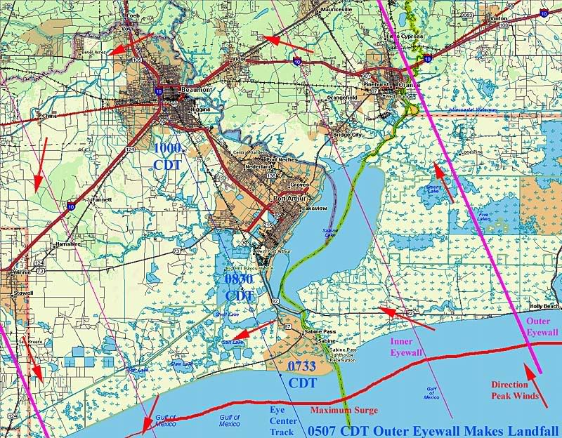
Rita's latest position puts it about 6 miles north of yesterday's 1700 (5pm VDT) track, and the newest projection agrees with that to some extent, but the placement of the individual plots mean that errors in curvature between plots could put landfall back where it was yesterday.
For now I'm assuming that the 1700 track is still good, so the large scale graphic showing storm surge is still up at:
http://i4.photobucket.com/albums/y138/jeffers_mz/02J.jpg
I've also made a new one, which reflects the 6 mile track shift to the right, a slightly smaller eyewall (28 mile inner radius, as opposed to the 40 mile radius used in the older image), and which is zoomed in to show Port Arthur, Beaumont, and Orange, along with projected surge, landfall times and peak wind directions along various tangent lines. For now, it's a safe bet that actual landfall will take place between the two indicated positions. The new graphic can be found here:
http://i4.photobucket.com/albums/y138/jeffers_mz/Rita/03Ritazoom.jpg
I also dug up some links to local newspapers.
Port Arthur:
http://www.panews.com/
Beaumont:
http://www.southeasttexaslive.com/site/news.asp?brd=2287
Orange:
http://www.orangeleader.com/
I'll be in and out here for a couple hours, then back for a long haul starting between 1am and 3 am.
Current projections have the eyewall first reaching land a little after 5 am, eye center landfall around 7:30, and eye center passing due south of Beaumont at 10 am (All times CDT).
The advisories show landfall happening earlier, what I think happens is that they expect the storm to slow after reaching land, but that falls between plot points so theres no way to estimate the times closer on the data given. Take the times with a grain of salt and remember that if they are wrong, things will most likely happen earlier than the times projected.
Did you noice that when Geraldo went out to show the wind's "fury" he was leaning to the left? In the background the rain was falling FROM the left. I don't think he was leaning into the wind...I think he was just leaning for effect.
Do you think we could add scanners now to the links at the page top. Probably need Houston, Beuamont, Galveston, Lake Charles.
LOL - or just people stuck on stupid making comments. :)
Like Jeraldo with his "transformers blowing up" talk every time he sees an electrical flash and hears the bang. I can guarantee that 99 out of 100 times, what he claims is a transformer blowing up is actually either a high-voltage distribution line touching a tree, a ground wire, or another conductor. Or maybe a lightning arrester giving up its life. Transformers fail, but not very often, and usually from direct lightning strikes after the lightning arrester has failed in the past or from overheating due to extreme loads.
Sorry - just a utility worker's rant against the typical lack of knowledge on the part of the media.
Gotta see this live camera of the wind on MSNBC. The wind is very impressive is Galveston.
Of course Rita Cosby has joined the fools in the wind.
I was out walking the dogs one last time. The darkness is surreal (given that it's only 8pm). From up in the tree, about 15 feet away, I hear a limb snap as the wind gusts. The yard, btw, has lots of twigs that weren't there just 30 minutes ago. Looks like the tree trimming has begun.
I hope you are lucky and keep your power throughout the night. Every five minutes or so the power goes off for a second and then comes back. I think we are living on borrowed power. The last hurricane -- a few weeks ago -- we had no power for 4 days. I think this should be the worst of it now.
Disclaimer: Opinions posted on Free Republic are those of the individual posters and do not necessarily represent the opinion of Free Republic or its management. All materials posted herein are protected by copyright law and the exemption for fair use of copyrighted works.