Morning folks.
Rita's latest position puts it about 6 miles north of yesterday's 1700 (5pm VDT) track, and the newest projection agrees with that to some extent, but the placement of the individual plots mean that errors in curvature between plots could put landfall back where it was yesterday.
For now I'm assuming that the 1700 track is still good, so the large scale graphic showing storm surge is still up at:
http://i4.photobucket.com/albums/y138/jeffers_mz/02J.jpg
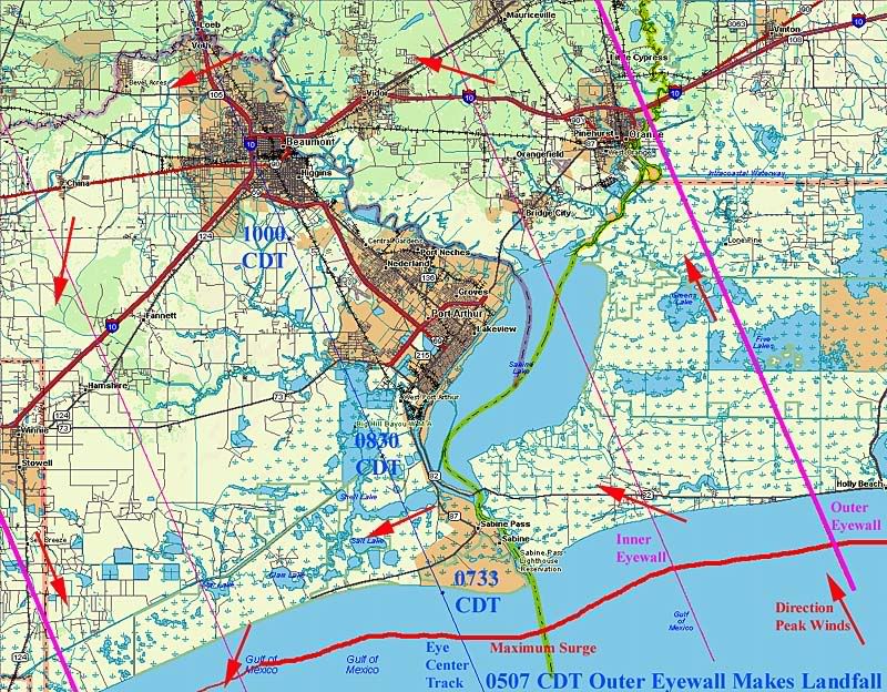
I've also made a new one, which reflects the 6 mile track shift to the right, a slightly smaller eyewall (28 mile inner radius, as opposed to the 40 mile radius used in the older image), and which is zoomed in to show Port Arthur, Beaumont, and Orange, along with projected surge, landfall times and peak wind directions along various tangent lines. For now, it's a safe bet that actual landfall will take place between the two indicated positions. The new graphic can be found here:
http://i4.photobucket.com/albums/y138/jeffers_mz/Rita/03Ritazoom.jpg
I also dug up some links to local newspapers.
Port Arthur:
http://www.panews.com/
Beaumont:
http://www.southeasttexaslive.com/site/news.asp?brd=2287
Orange:
http://www.orangeleader.com/
I'll be in and out here for a couple hours, then back for a long haul starting between 1am and 3 am.
Current projections have the eyewall first reaching land a little after 5 am, eye center landfall around 7:30, and eye center passing due south of Beaumont at 10 am (All times CDT).
The advisories show landfall happening earlier, what I think happens is that they expect the storm to slow after reaching land, but that falls between plot points so theres no way to estimate the times closer on the data given. Take the times with a grain of salt and remember that if they are wrong, things will most likely happen earlier than the times projected.
Mornin'/evening. The track based on the last 2 vortex reports (eye fixes at 3:31 pm and 6:03 pm put the motion over that 2 1/2 hours at 322 degrees and 11 mph. That 6:03 position put it 103 miles and a 326 degree course out Sabine Pass. Extrapolating, that, that should put landfall about 3:30 am 15 miles west of Sabine Pass.
I also found a pretty good longitude/latitude converter (accepts either DDMMSS or DD.DDD, and outputs in true course and nm distance) - http://www.airways.com/java/coordcalc.html
That helped me immensely in plotting both the vortex reports and the alternating-on-the-hour advisories and position updates.