
| This thread has been locked, it will not receive new replies. |
|
Locked on 09/23/2005 8:02:43 PM PDT by Admin Moderator, reason:
New Thread: http://www.freerepublic.com/focus/f-news/1490378/posts |
Posted on 09/23/2005 9:39:06 AM PDT by NautiNurse
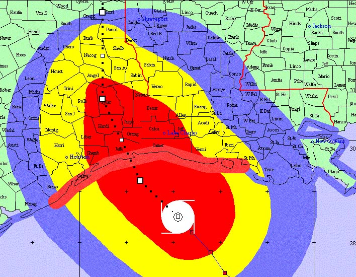
Dangerous Hurricane Rita is expected to make landfall in the northeast Gulf of Mexico within 24 hours. Tornados have spawned in Louisiana. Water is filling the Ninth Ward of New Orleans again. A bus carrying elderly evacuees was gutted by fire this morning outside Dallas, with multiple fatalities. Television crews have positioned their hurricane reporters throughout the region to attain maximum drama effects. Whoooooa.
The following links are self-updating:
Public Advisory Currently published every 3 hours 5A, 8A, 11A, 2P, etc. ET
NHC Discussion Published every six hours 6A, 11A, 6P, 11P
Three Day Forecast Track
Five Day Forecast Track
Rita Forecast Track Archive
Forecast Models
Buoy Data Western Gulf of Mexico
Houston/Galveston/Beaumont/Lake Charles Wx Watches/Warnings
Jefferson Co TX NWS Weather
Current Weather Warnings and Watches for Texas
Current Weather Warnings and Watches for Louisiana
Hi Res Houston Flood Zone Map Slow load, great detail
Images:
Lake Charles Long Range Radar Still image, with loop link
Houston/Galveston Long Range Radar Still image, with loop link
Lake Charles Experimental Radar Outages and Delays May Occur
Storm Floater IR Loop
GOM WV Loop
GOM IR Still Image
Visible Storm Floater Still (only visible during daylight hours)
Color Enhanced Atlantic Loop
Streaming Video: (coverage may be intermittent)
KHOU-TV/DT Houston
KPRC-TV/DT Houston
KTRK-TV/DT Houston
KTRH-AM Houston
KPLC-TV/DT Lake Charles/Lafayette
KSLA-TV/DT Shreveport
Additional Resources:
FReeper Sign In Thread Check in to let us know whether you are staying, going, and when you get there
FReepers Offering Lodging To Rita Evacuees People and/or Pet Friendly FReepers Offering Shelter
KHOU Houston
KTRK ABC News Houston
KPLC Lake Charles Evac Routes, news
KFDM Beaumont/Port Arthur News, evac info
Hurricane City
Wxnation Houston
Galveston Webcams
Golden Triangle Weather Page Provides Galveston Weather, Warnings, Radar, etc.
| Category | Wind Speed | Barometric Pressure | Storm Surge | Damage Potential |
|---|---|---|---|---|
| Tropical Depression |
< 39 mph < 34 kts |
Minimal | ||
| Tropical Storm |
39 - 73 mph 34 - 63 kts |
Minimal | ||
| Hurricane 1 (Weak) |
74 - 95 mph 64 - 82 kts |
28.94" or more 980.02 mb or more |
4.0' - 5.0' 1.2 m - 1.5 m |
Minimal damage to vegetation |
| Hurricane 2 (Moderate) |
96 - 110 mph 83 - 95 kts |
28.50" - 28.93" 965.12 mb - 979.68 mb |
6.0' - 8.0' 1.8 m - 2.4 m |
Moderate damage to houses |
| Hurricane 3 (Strong) |
111 - 130 mph 96 - 112 kts |
27.91" - 28.49" 945.14 mb - 964.78 mb |
9.0' - 12.0' 2.7 m - 3.7 m |
Extensive damage to small buildings |
| Hurricane 4 (Very strong) |
131 - 155 mph 113 - 135 kts |
27.17" - 27.90" 920.08 mb - 944.80 mb |
13.0' - 18.0' 3.9 m - 5.5 m |
Extreme structural damage |
| Hurricane 5 (Devastating) |
Greater than 155 mph Greater than 135 kts |
Less than 27.17" Less than 920.08 mb |
Greater than 18.0' Greater than 5.5m |
Catastrophic building failures possible |
Previous Threads:
Hurricane Rita Live Thread, Part V
Hurricane Rita Live Thread, Part IV
Hurricane Rita Live Thread, Part III
Hurricane Rita Live Thread, Part II
Hurricane Rita Live Thread, Part I
Tropical Storm Rita
Tropical Depression 18
No, not at all. ha
Take care, and Godspeed. Keeping you and all of your Texas neighbors in our prayers.
SERIOUS trouble tonight for Port Arthur and Beaumont - latest track forecast takes this thing right through both cities
LATEST NWS TRACK FORECAST FOR RITA
http://www.usawx.com/ritapathforecastfridaynightsept23rdpy.jpg
Be careful and remember my offer!
I knew Shep was TICKED he could not be in the action, so he left Galveston.
The Placid refinery was built in 1976? I didn't realize that. Thanks.
Is this monster still 410 miles wide?
Yep - I'm not too far from you in the Dc metro area. By the way - the name of that new activity near Cuba will be Stan, I think, if it becomes name worthy.
Wind is picking up and the sky a really funky color.
| Wind Direction (WDIR): | NNW ( 340 deg true ) |
| Wind Speed (WSPD): | 27.2 kts |
| Wind Gust (GST): | 35.0 kts |
| Wave Height (WVHT): | 15.4 ft |
| Dominant Wave Period (DPD): | 10 sec |
| Average Period (APD): | 7.3 sec |
| Mean Wave Direction (MWDIR): | E ( 92 deg true ) |
| Atmospheric Pressure (PRES): | 29.41 in |
| Pressure Tendency (PTDY): | -0.04 in ( Falling ) |
| Air Temperature (ATMP): | 86.9 °F |
| Water Temperature (WTMP): | 84.6 °F |
| Dew Point (DEWP): | 72.7 °F |
| Heat Index (HEAT): | 93.9 °F |
| Combined plot of Wind Speed, Gust, and Air Pressure | |
| TIME(CDT) | WDIR | WSPD |
|---|---|---|
| 6:50 pm | NNW ( 343 deg ) | 27.6 kts |
| 6:40 pm | NNW ( 342 deg ) | 30.1 kts |
| 6:30 pm | NNW ( 339 deg ) | 26.6 kts |
| 6:20 pm | NNW ( 342 deg ) | 31.5 kts |
| 6:10 pm | NNW ( 341 deg ) | 28.7 kts |
| 6:00 pm | NNW ( 340 deg ) | 27.4 kts |
Natural gas prices are over a buck a therm...I think Jeb said to not use energy for a while.
What is your problem?? I didn't post the info that you are becomming hysterical about. If you have a complaint, take it up with the poster that heard it and reported it.
Got it? Good
Stay safe.
Geraldo sounds like he's reporting from the bottom of a toilet.
I heard Tampa Bay area has plenty of gasoline. Shipments were increased to Port of Tampa following Katrina. That's what we were told, anyway.
Steve Harrigan. I guess he hasn't recovered yet, I have yet to see him this storm.
I am sooo thanful I do not have cable TeeVee - yet can rely on my FRiends to relay whatever info they have, w/p having to look at it.
Yes, it will be Stan, unless something else forms first...
Disclaimer: Opinions posted on Free Republic are those of the individual posters and do not necessarily represent the opinion of Free Republic or its management. All materials posted herein are protected by copyright law and the exemption for fair use of copyrighted works.