Free Republic
Browse · Search
News/Activism
Topics · Post Article

To: Velveeta; LikeLight; Rutles4Ever; All
To me the picture represents the water as the great lakes area. The land area when looking at the drawing from right to left...the state of Maine could the part of the drawing on the very right.

I believe that the BP refinery blast in Whiting, Indiana was Aug. 13th and the refinery is located on Lake Michigan. "BP said a blast at its 420,000-barrel-a-day Whiting refinery, the nation's third biggest, had closed a petroleum product processing unit...."


3,896 posted on 08/24/2004 10:36:07 AM PDT by all4one ("..a politician is to be judged by the animosities he excites among his opponents" Sir W. Churchill)
[ Post Reply | Private Reply | To 3885 | View Replies ]


To: all4one

That was what I thought when I first saw the pic: I saw the tiny twin bumps at the right as possibly Maine. Glad to hear someone else saw that too. Yet the two states others identified as possibly Idaho and Montana also seem likely.


3,898 posted on 08/24/2004 11:08:50 AM PDT by Donna Lee Nardo
[ Post Reply | Private Reply | To 3896 | View Replies ]

To: all4one

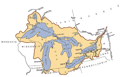
Have to disagree. the drawing is obviously not a great map, but the jut on the jihadi N. Dakota is actually in Minneosta. It appears the land at the end might be the upper peninsula of Michigan or Wisconsin or rep. of both.

3,904 posted on 08/24/2004 11:44:38 AM PDT by Rutles4Ever
[ Post Reply | Private Reply | To 3896 | View Replies ]

Free Republic
Browse · Search
News/Activism
Topics · Post Article


FreeRepublic, LLC, PO BOX 9771, FRESNO, CA 93794
FreeRepublic.com is powered by software copyright 2000-2008 John Robinson