Skip to comments.
Mars Exploration Rover Mission
JPL ^
| 1-3-04
| JPL
Posted on 01/03/2004 9:33:30 AM PST by bonesmccoy
Mission Timeline: Entry, Descent, and Landing
The entry, descent, and landing (EDL) phase begins when the spacecraft reaches the Mars atmospheric entry interface point (3522.2 kilometers or about 2,113 miles from the center of Mars) and ends with the lander on the surface of Mars in a safe state.
The rovers will arrive during the latter half of the northern winter/southern summer on Mars. Rover A will land at approximately 2:00 p.m. local time on Mars (with Earth set an hour after landing), whereas Rover B will land at around 1:15 p.m. local time on Mars (with Earth set as long as two-and-a-half hours after landing). That means that both rovers will land in the Martian afternoon while the Earth is still in view, allowing the Earth to receive the landing signal if the lander is on the base petal.
Entry, descent, and landing for the Mars Exploration Rover mission is an adaptation of the Mars Pathfinder method:
An aeroshell and a parachute decelerate the lander through the Martian atmosphere.
Prior to surface impact, retro-rockets are fired to slow the lander´s speed of descent, and airbags are inflated to cushion the lander at surface impact.
After its initial impact, the lander bounces along the Martian surface until it rolls to a stop.
The airbags are then deflated and retracted, and the lander petals and rover egress aids are deployed.
Once the petals have opened, the rover deploys its solar arrays, and places the system in a safe state. Communications during entry, descent, and landing will occur through a pair of low-gain antennas, one mounted on the backshell and the other on the rover itself. About 36 ten-second radio tones will be transmitted to Earth during descent through the atmosphere, which takes approximately six minutes. These tones are coded to indicate the accomplishment of critical steps in the entry, descent,and landing timeline. [More on these tones in the communications section]
A step-by-step guide to everything that will happen will be provided prior to entry, descent, and landing.
TOPICS: Culture/Society; Extended News; Government; News/Current Events; Technical
KEYWORDS: jpl; mars; nasa; nasatv; space
Navigation: use the links below to view more comments.
first previous 1-20 ... 2,761-2,780, 2,781-2,800, 2,801-2,820 ... 2,841-2,855 next last
To: GeronL
Or maybe a tidal plain? I can't wait to see more pics.
To: bonesmccoy
This picture has me intrigued. It certainly does look like soil that has been disturbed by the gasbags. And that does look like a fragment of something, one of the bags perhaps?
Also, the way that soil looks that has been disturbed, it reminds me of silt forming at the bottom of a pond.......
2,782
posted on
01/06/2004 7:10:50 PM PST
by
Paradox
(Cogito ergo boom.)
To: bonesmccoy
I'm struck by the black patina on the reddish rocks. It reminds me of the black patina seen in the canyonlands on some of the red sand stones of the American South West. In those cases the black is actually of organic origins. . . . long shot here, though. The blackish patina on the mars rocks is probably just weathered ferrous material.
To: djf
Yes the rover has an arm, but there's no end effector (hand). There is a RAT (rock abrasion tool) that could probably push the rock around though.
Have you noticed how smooth those rocks look?
They're nothing like the rocks seen where Pathfinder touched down or where Viking landed.

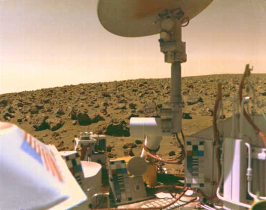
Original Caption Released with Image: This color picture of Mars was taken July 21--the day following Viking l's successful landing on the planet. The local time on Mars is approximately noon. The view is southeast from the Viking. Orange-red surface materials cover most of the surface, apparently forming a thin veneer over darker bedrock exposed in patches, as in the lower right. The reddish surface materials may be limonite (hydrated ferric oxide). Such weathering products form on Earth in the presence of water and an oxidizing atmosphere. The sky has a reddish cast, probably due to scattering and reflection from reddish sediment suspended in the lower atmosphere. The scene was scanned three times by the spacecraft's camera number 2, through a different color filter each time. To assist in balancing the colors, a second picture was taken of z test chart mounted on the rear of the spacecraft. Color data for these patches were adjusted until the patches were an appropriate color of gray. The same calibration was then used for the entire scene. Image Note: CE LABEL 12A006/001
_______________________
Viking 2 photo

Utopian Plain The boulder-strewn field of red rocks reaches to the horizon nearly two miles from Viking 2 on Mars' Utopian Plain. Scientists believe the colors of the Martian surface and sky in this photo represent their true colors. Fine particles of red dust have settled on spacecraft surfaces. The salmon color of the sky is caused by dust particles suspended in the atmosphere. Color calibration charts for the cameras are mounted at three locations on the spacecraft. Note the blue starfield and red stripes of the flag. The circular structure at top is the high- gain antenna, pointed toward Earth. Viking 2 landed September 3, 1976, some 4600 miles from its twin, Viking 1, which touched down on July 20. Note: Unsure if this is from Camera 1 or Camera 2. This image was scanned from physical media.
____________________________
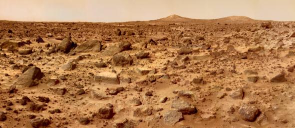
Pathfinder shot a stereoscopic view that I'll post subsequent to this one.

Original Caption Released with Image: The Twin Peaks are modest-size hills to the southwest of the Mars Pathfinder landing site. They were discovered on the first panoramas taken by the IMP camera on the 4th of July, 1997, and subsequently identified in Viking Orbiter images taken over 20 years ago. The peaks are approximately 30-35 meters (-100 feet) tall. North Twin is approximately 860 meters (2800 feet) from the lander, and South Twin is about a kilometer away (3300 feet). The scene includes bouldery ridges and swales or 'hummocks' of flood debris that range from a few tens of meters away from the lander to the distance of the South Twin Peak. The composite color frames that make up this 'left-eye' image consist of 8 frames, taken with different color filters that were enlarged by 500% and then co-added using Adobe Photoshop to produce, in effect, a super-resolution panchromatic frame that is sharper than an individual frame would be. This panchromatic frame was then colorized with the red, green, and blue filtered images from the same sequence. The color balance was adjusted to approximate the true color of Mars.
This image and PIA02406(right eye) make up a stereo pair.
Mars Pathfinder is the second in NASA's Discovery program of low-cost spacecraft with highly focused science goals. The Jet Propulsion Laboratory, Pasadena, CA, developed and manages the Mars Pathfinder mission for NASA's Office of Space Science, Washington, D.C. JPL is a division of the California Institute of Technology (Caltech). The IMP was developed by the University of Arizona Lunar and Planetary Laboratory under contract to JPL. Peter Smith is the Principal Investigator.
2,784
posted on
01/06/2004 8:37:11 PM PST
by
bonesmccoy
(defend America...get vaccinated.)
To: bonesmccoy


Pathfinder site
2,785
posted on
01/06/2004 8:49:48 PM PST
by
bonesmccoy
(defend America...get vaccinated.)
To: Phil V.
What makes the dark color?
Is that unoxidized iron content in the soil?
2,786
posted on
01/06/2004 8:51:06 PM PST
by
bonesmccoy
(defend America...get vaccinated.)
To: Paradox
At first I thought an air bag liner was still on the surface. Now, I realize that the surface is dark under the rocks.
I think the surface rocks were being pushed by the air bags. The rocks dragged the soil and revealed a darker toned soil under the surface. The end result was that the darker soil hasn't had the opportunity to oxidize in the fashion that the surface has.
2,787
posted on
01/06/2004 9:00:09 PM PST
by
bonesmccoy
(defend America...get vaccinated.)
To: bonesmccoy
Is that a "mark" from the air bag? It's a mark. note that some rocks were pounded into the surface and have that 'muddy' looking soil smushed up in a ring around them.
2,788
posted on
01/06/2004 9:08:16 PM PST
by
null and void
(It's a guy thing, we don't understand it either...)
To: bonesmccoy
In your
first posted sterio side-by-side there are two features that I'd really like to examine closer if I were the one driving the rover.

As I examine the area between the two straight lines I see that this formation (strata? sedimentary??) appears to be tilted near vertical and slightly toward the camera. The far side of this formation appears to be 6 to 12 inches lower. . . . a drop off. I'd have rover drill into the far face to determine if it is indeed sedimentary.
The other point of interest revealed by my high tech turn-of-the-century stereoscope is in the oval. IT LOOKS LIKE A SPLIT GEODE . . . or clam shell . . . harrr! Very slim chance, but I'd really like a closer look. . . . Thanks again for the point to stereo. Will there be color stereos?
To: null and void
I hope they take more images of this area. The rocks seem to have unveiled a darker soil under the lighter red coating. It reminds me of the Viking 1 and 2 arm digging up soil in 1976.
2,790
posted on
01/06/2004 9:14:59 PM PST
by
bonesmccoy
(defend America...get vaccinated.)
To: Phil V.
I agree with you Phil. I was trying to get in touch with my friend and left him a message on Sunday. I'm sure he's really busy getting things ready for Opportunity, so I haven't heard back from him yet.
I agree with your observation of the drop off. That was the "ravine" that I noted too.
The real issue to me is "what in the heck is a ravine doing on Mars?"
Ravines are supposed to be carved out by water. This Gusev Crater target was choice. They've managed to put the lander right in the middle of some kind of lake bed. I didn't believe them when they said "lake bed" because I always envisioned Mars as a failed planet (no water).
This place makes me think that water could be a few feet under the soil.
Certainly, that photo of the rocks unveiling the darker colored soil under them (in the air bag skid mark) didn't dissuade the idea that moisture exists in the under soil.
Here's comments on the atmospheric pressure on Mars (earlier in the thread I incorrectly stated 70-80 mmHg from memory). I was incorrect. I was 7 mmHg!
______________________
Mars has a very thin atmosphere composed mostly of the tiny amount of remaining carbon dioxide (95.3%) plus nitrogen (2.7%), argon (1.6%) and traces of oxygen (0.15%) and water (0.03%). The average pressure on the surface of Mars is only about 7 millibars (less than 1% of Earth's), but it varies greatly with altitude from almost 9 millibars in the deepest basins to about 1 millibar at the top of Olympus Mons. But it is thick enough to support very strong winds and vast dust storms that on occasion engulf the entire planet for months. Mars' thin atmosphere produces a greenhouse effect but it is only enough to raise the surface temperature by 5 degrees (K); much less than what we see on Venus and Earth.
2,791
posted on
01/06/2004 9:27:58 PM PST
by
bonesmccoy
(defend America...get vaccinated.)
To: HighWheeler
Thanks for the cool idea... did you see the images in 3d?
2,792
posted on
01/06/2004 9:35:04 PM PST
by
bonesmccoy
(defend America...get vaccinated.)
To: bonesmccoy
Assuming we do locate evidence of past life on Mars, is that life entitled to Social Security benefits?
To: DFW_Repub
This mission is not capable of detecting biological activity. However, since the mission is being controlled from Calleyfourneyah, there is the possibility that the Martian vote may put a referendum on the November '04 ballot! (LOL)
2,794
posted on
01/06/2004 9:41:02 PM PST
by
bonesmccoy
(defend America...get vaccinated.)
To: bonesmccoy
What makes the dark color? The most exotic answer would be an organic process - the same as the one that stains the red sandstone black on some of the cliff faces in the south west. . . .slim to none, but what th' hey!!
The most likely (a MORE likely) answer would be that it is at a different level of oxidation and a different level of hydrated iron.
Comment #2,796 Removed by Moderator
Comment #2,797 Removed by Moderator
Comment #2,798 Removed by Moderator
To: bonesmccoy
The rocks at the current site do look smoother, but you can still see some sharp features to them. I suspect that since this area is about the flattest we have been to, the culprit is wind abrasion. Here is a shot of material collected from the debris field of Shasta. It's hard to get the exposure right with my cheapo digicam! But the interior has a distinct pink/red flavor, whilst the exterior has been darkened, I don't think it's oxidation, rather some photochemical effect. (light exposure)

2,799
posted on
01/07/2004 2:31:24 AM PST
by
djf
To: bonesmccoy
"... did you see the images in 3d?"
Oh yeah, they are beautiful, you did a great job piecing the images together.
2,800
posted on
01/07/2004 5:28:16 AM PST
by
HighWheeler
(Death is better than taxes because death doesn't get worse every year.)
Navigation: use the links below to view more comments.
first previous 1-20 ... 2,761-2,780, 2,781-2,800, 2,801-2,820 ... 2,841-2,855 next last
Disclaimer:
Opinions posted on Free Republic are those of the individual
posters and do not necessarily represent the opinion of Free Republic or its
management. All materials posted herein are protected by copyright law and the
exemption for fair use of copyrighted works.
FreeRepublic.com is powered by software copyright 2000-2008 John Robinson


