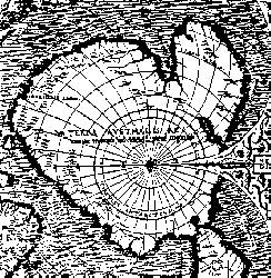
In 1929 a group of historians found half of the map in the Palace of Topkapu (Istanbul where it remains, facsimile available at the Library of Congress Washington DC) on a dusty shelf, still rolled up and drawn on a gazelle skin. The content of the map was amazing: it focused on the western coast of Africa, the eastern coast of South America (!) and the northern coast of Antarctica (!!!). The most flabbergasting point is that Antarctic had remained undiscovered until 1818, but its northern coastline, perfectly detailed, was shown on this map drawn in 1513.
What this doesn't tell you is that the coastline of Antartica is the coastline of the continent WITHOUT the ice... which was only determined by radar and echo location soundings in 1949!
![]()
The Map of Piri Reis
Another map that is anacrhonistic is the Ornotius Finaeus Delphinus Map created in 1531 which shows the entire continent of Antarctica along with mountain ranges, rivers, bays... that have only recently been found to exist where Finaeus' map shows them.
A: The Map of Orontius Finaeus Delphinus
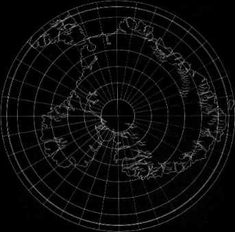
B; Finaeus Map redrawn on modern polar projections
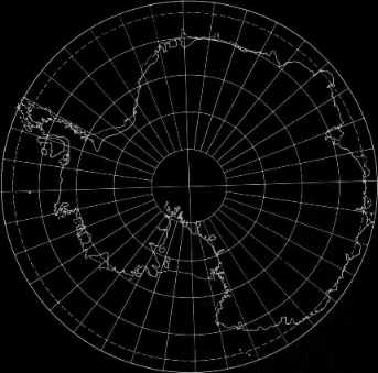
C: Antartica on polar projection
Here is the text of a letter written to Professor Charles Hapgood analysing the Piri Reis Map:
" It is not very often that we have the opportunity to evaluate maps of ancient origin. The Piri Reis ( AD 1513 ) and the Oronteus Fineaus [sic] ( AD 1531 ) maps sent to us by you, presented a delightful challenge for it was not readily conceivable that they could be so accurate without being forged. With added enthusiasm we accepted this challenge and have expended many off duty hours evaluating your manuscript and the above maps. I am sure you will be pleased to know that we have concluded that both of these maps were compiled from accurate original source maps, irrespective of dates. The following is a brief summary of our findings:
A. The solution of the portolano projection used by Admiral Piri Reis, developed by your class in Anthropology must be very nearly correct; for when known geographical locations are checked in relationship to the grid computed by Mr. Richard W. Strachan ( MIT ), there, is remarkably close agreement. Piri Reis' use of the Portolano projection ( centred on Syene, Egypt ) is an excellent choice, for it is a developable surface that would permit the relative size and shape of the earth at that ( lattitude ) to be retained. It is our opinion that those who compiled the original map had an excellent knowledge of the continents covered by this map.
B. As stated by Colonel Harold Z. Ohlmeyer in his letter ( July 6, 1960 ) to you, the Princess Martha Coast of Queen Maud Land, Antarctica, appears to be truly represented on the southern sector of the Piri Reis Map. The agreement of the Piri Reis map with the seismic profile of this area made by the Norwegian-British -Swedish Expedition of 1949, suported by your solution of the grid, places beyond a reasonable doubt the conclusion that the original source maps must have been made before the present Antarctic ice cap covered Queen Maud Land coasts.
C. It is our opinion that the accuracy of the cartographic features shown in the Oronteus Fineaus [sic] Map ( AD 1530 ) suggests, beyond a doubt, that it also was compiled from accurate source maps of Antarctica, but in this case of the entire continent. Close examination has proved the original source maps must have been compiled at a time when the land mass and inland waterways of the continent were relatively free of ice. This conclusion is further supported by a comparison of the Oronteus Finneaus [sic] Map with the results obtained by International Geophysical Year teams in their measurements of the subglacial topography. The comparison also suggests that the original source maps ( compiled in remote antiquity ) were prepared when Antarctica was presumably free of ice. The Cordiform projection used by Oronteus Fineaus [sic] suggests the use of advanced mathematics. Further, the shape given to the Antarctic continent suggests the possibility, if not the probability, that the original source maps were compiled on a stereographic or gnomonic type of projection ( involving the use of spherical trigonometry ).
D. We are convinced that the findings made by you and your associates are valid, and that they raise extremely important questions affecting geology and ancient history, questions which certainly require further investigation.
We thank you for extending us the opportunity to have participated in the study of these maps. The following officers and airmen vollunteered their time to assist Captain Lorenzo W.Burroughs in this evaluation: Captain Richard E. Covault, CWO Howard D.Minor, MSgt Clifton M.Dover, MSgt DAvid C.Carter, TSgt James H.Hood, SSgt James L.Carroll, and AIC Don R.Vance."
Lorenzo W.Burroughs
Captain, USAF
Chief, Cartographic Section
8th Reconnaissance Technical Sqdn ( SAC ) Westover, Mass.