Free Republic
Browse · Search
News/Activism
Topics · Post Article

Skip to comments.

Hurricane Isabel:Live Thread #2 "Force Ten Conditions In North Carolina And Further North"
NHC | 9-17-03 | My Favorite Headache

Posted on 09/17/2003 8:14:30 PM PDT by My Favorite Headache

Hurricane Isabel Advisory Number 48

Statement as of 11:00 PM EDT on September 17, 2003

...Outer bands of Hurricane Isabel moving onshore...weather should gradually worsen...

A Hurricane Warning remains in effect from Cape Fear North Carolina to Chincoteague Virginia...including Pamlico and Albemarle sounds...and the Chesapeake Bay south of Smith Point. A Hurricane Warning means that hurricane conditions are expected within the warning area...generally within 24 hours.

All preparations to protect life and property should be rushed to completion in the Hurricane Warning area.

A Tropical Storm Warning remains in effect south of Cape Fear to South Santee River South Carolina...and north of Chincoteague to Sandy Hook New Jersey...including Delaware Bay. A Tropical Storm Warning also remains in effect for the Chesapeake Bay from Smith Point northward...and for the tidal Potomac.

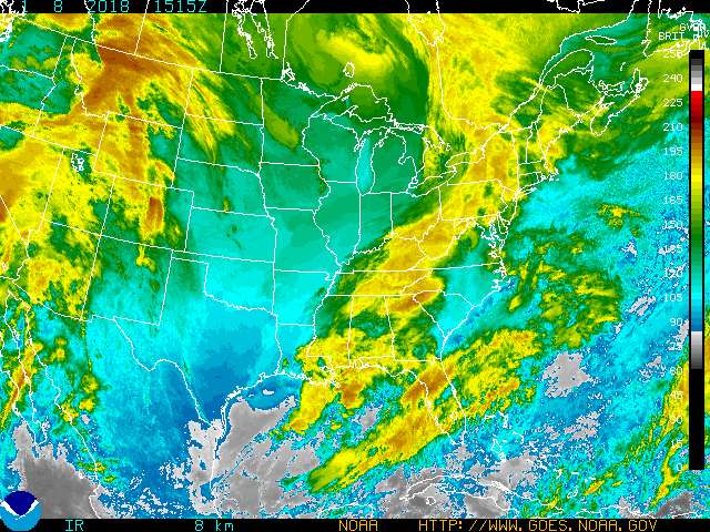
At 11 PM EDT...0300z...the center of Hurricane Isabel was located by an Air Force reconnaissance aircraft near latitude 31.9 north... longitude 73.9 west or about 250 miles south-southeast of Cape Hatteras North Carolina.

Isabel is moving toward the north-northwest near 13 mph. A turn to the northwest with an increase in forward speed is expected prior to landfall. On the forecast track...the center of Isabel is expected to make landfall in eastern North Carolina during the day Thursday. However...conditions will deteriorate over a large area well before the center reaches the coast. Tropical storm conditions are already spreading across the coastline.

Maximum sustained winds are near 105 mph...with higher gusts. A slight increase in strength is possible prior to landfall.

Hurricane force winds extend outward up to 115 miles from the center...and tropical storm force winds extend outward up to 315 miles. A buoy located west of the hurricane recently reported wind gusts to 74 mph and 32 foot waves.

An Air Force hurricane hunter plane recently reported a minimum central pressure of 956 mb...28.23 inches.

Storm surge flooding of 7 to 11 feet above normal tide levels... along with extremely large and dangerous battering waves...is expected near and to the north of where the center crosses the coast. Storm surge flooding of 4 to 8 ft above normal tide levels is expected in Chesapeake Bay and the tidal portions of adjacent rivers.

Storm total rainfalls of 6 to 10 inches...with locally higher amounts...are likely in association with Isabel.

There is a threat of isolated tornadoes over eastern North Carolina and southeastern Virginia on Thursday.

Repeating the 11 PM EDT position...31.9 N... 73.9 W. Movement toward...north-northwest near 13 mph. Maximum sustained winds...105 mph. Minimum central pressure... 956 mb.

For storm information specific to your area...please monitor products issued by your local weather office.

An intermediate advisory will be issued by the National Hurricane Center at 2 am EDT followed by the next complete advisory at 5 am EDT.

Forecaster Avila


TOPICS: Breaking News; News/Current Events; US: North Carolina; US: Virginia
KEYWORDS: hurricane; hurricaneisabel; isabel; landfall
Navigation: use the links below to view more comments.
first previous 1-20 ... 361-380381-400401-420 ... 2,161-2,170 next last
To: Hatteras
In other words, all the dingbatters left, and the natives are riding it out.

Dingbatter is a local term for "people not from around here".

My aunt and uncle and great aunts and uncles and 1st, 2nd and 3rd cousins are all riding it out in Atlantic (that's not Atlantic Beach), which is right next to Cedar Island.
381 posted on 09/18/2003 5:33:25 AM PDT by wimpycat (Down with Kooks and Kookery!)
[ Post Reply | Private Reply | To 376 | View Replies]

To: Gabz
We just had an employee call in from southeast Raleigh saying his power's out at home. He lives out near Altel Pavilion.
382 posted on 09/18/2003 5:35:58 AM PDT by Hatteras (where the Gulf Stream meets the Labrador Current...)
[ Post Reply | Private Reply | To 378 | View Replies]

To: Hatteras
Oh fun............
383 posted on 09/18/2003 5:36:54 AM PDT by Gabz (anti-smokers - personification of everything wrong in this country.)
[ Post Reply | Private Reply | To 382 | View Replies]

To: Hatteras
He said Altel... I thought it was Walnut Creek.... Hmmm, haven't been there in awhile, I guess.
384 posted on 09/18/2003 5:39:02 AM PDT by Hatteras (where the Gulf Stream meets the Labrador Current...)
[ Post Reply | Private Reply | To 382 | View Replies]

To: Constitution Day
Keep us posted, CD. We're thinking about you.
385 posted on 09/18/2003 5:41:05 AM PDT by NautiNurse
[ Post Reply | Private Reply | To 377 | View Replies]

To: wimpycat
Nice view of the US providing perspective of Isabel's size
386 posted on 09/18/2003 5:46:55 AM PDT by NautiNurse
[ Post Reply | Private Reply | To 381 | View Replies]

To: NautiNurse
Steve Doocie on Fox now saing the eyewall will come around the same time as high tide.
387 posted on 09/18/2003 5:47:14 AM PDT by Miss Marple
[ Post Reply | Private Reply | To 385 | View Replies]

To: NautiNurse
holy moley, she's a big'un!
388 posted on 09/18/2003 5:48:08 AM PDT by xsmommy
[ Post Reply | Private Reply | To 386 | View Replies]

To: NautiNurse; xsmommy
We're toast.
389 posted on 09/18/2003 5:50:46 AM PDT by Gabz (anti-smokers - personification of everything wrong in this country.)
[ Post Reply | Private Reply | To 386 | View Replies]

To: Gabz
We're toast.

Wet toast! Prayers for all in the path.

390 posted on 09/18/2003 5:55:12 AM PDT by CFW
[ Post Reply | Private Reply | To 389 | View Replies]

To: CFW
LOL!!!
391 posted on 09/18/2003 5:55:48 AM PDT by Gabz (anti-smokers - personification of everything wrong in this country.)
[ Post Reply | Private Reply | To 390 | View Replies]

To: Miss Marple
Fired up my trusty tide calculator...

Normal High Tides:

Morehead City 2:05PM 3.3ft

Cape Hatteras Fishing Pier 1:31PM 3.1ft

Virginia Beach 1:42PM 3.7ft

Chesapeake Bay Bridge-Tunnel 2:07PM 2.7ft

392 posted on 09/18/2003 5:57:15 AM PDT by NautiNurse
[ Post Reply | Private Reply | To 387 | View Replies]

To: NautiNurse
Thanks. I am fine for now.
393 posted on 09/18/2003 5:59:34 AM PDT by Constitution Day
[ Post Reply | Private Reply | To 385 | View Replies]

To: Gabz
Good grief--already reports of 100K without power. Gonna be a long weekend, fer sure.
394 posted on 09/18/2003 6:01:27 AM PDT by NautiNurse
[ Post Reply | Private Reply | To 389 | View Replies]

To: honeygrl
If you think Raleigh is bad, visit Durham! It has the added joy of a massive number of one-way streets and no grid pattern to speak of!
395 posted on 09/18/2003 6:04:18 AM PDT by NCjim
[ Post Reply | Private Reply | To 153 | View Replies]

To: NCjim
a massive number of potholed one-way streets
396 posted on 09/18/2003 6:05:34 AM PDT by NautiNurse
[ Post Reply | Private Reply | To 395 | View Replies]

To: Howlin
Except for my daughter's school which is open until 11:45 as are a few other private schools.
397 posted on 09/18/2003 6:05:43 AM PDT by NCjim
[ Post Reply | Private Reply | To 159 | View Replies]

To: Constitution Day
Be safe CD.
398 posted on 09/18/2003 6:07:03 AM PDT by Neets (<---Yankee Hurrycane watcher now!(Watching it pass right under me))
[ Post Reply | Private Reply | To 377 | View Replies]

To: NCjim
As usual, we are working at Blue Cross in Durham. They'll wait until it gets bad and then let us go drive home in the 50 mph winds. Typical.
399 posted on 09/18/2003 6:07:52 AM PDT by holdmuhbeer
[ Post Reply | Private Reply | To 397 | View Replies]

To: NautiNurse
Oh boy.

It has started raining in northern Accomac County.
400 posted on 09/18/2003 6:08:50 AM PDT by Gabz (anti-smokers - personification of everything wrong in this country.)
[ Post Reply | Private Reply | To 394 | View Replies]


Navigation: use the links below to view more comments.
first previous 1-20 ... 361-380381-400401-420 ... 2,161-2,170 next last

Disclaimer: Opinions posted on Free Republic are those of the individual posters and do not necessarily represent the opinion of Free Republic or its management. All materials posted herein are protected by copyright law and the exemption for fair use of copyrighted works.

Free Republic
Browse · Search
News/Activism
Topics · Post Article

FreeRepublic, LLC, PO BOX 9771, FRESNO, CA 93794
FreeRepublic.com is powered by software copyright 2000-2008 John Robinson