Because the "inland seashells" are from *multiple different time periods* -- and the times even vary from place to place. If there were a global flood, there would be a large layer of seashells in all places, all in a single strata that measured to the same time period. Furthermore, even single locations will often have a layer of sea shells, with a layer of geologic formation on top of that which can only be formed under *dry* conditions, followed by another layer of sea shells. Kind of hard to explain *that* by invoking a one-time global flood.
To even suggest that their presence is evidence of continental drift is preposterous.
And yet, that's exactly what the enormous amounts of geological evidence indicates, to the exclusion of any "global flood" hypothesis. Deal with it.
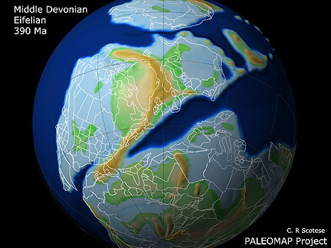
Here's what North America, Africa, and Europe looked like 390 million years ago:

(Image courtesy of the excellent Paleomap Project website, which is a good starting point for education about how the Earth has changed over time, and how we know.)
The light blue areas are shallow seas, which as you'll notice cover most of what are today "inland" areas.
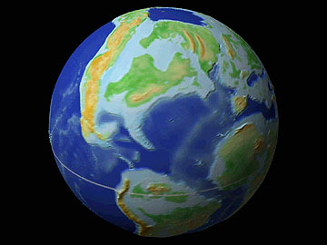
Even as recently as 80 million years ago there were extensive "inland seas":

How do we know this is what the Earth was like 390 (or 80) million years ago? From careful reconstruction from literally millions of pieces of data acquired from such independent sources as paleomagnetism, linear magnetic anomalies, paleobiogeography, paleoclimatology, geologic and tectonic history, and the nature of various geologic strata from location to location.
Reconstructions of the configuration of the Earth in the past are based on such research and measurements as:
Barron, E.J., Fawcett, P.J., Pollard, D., and Thompson, S., 1994. Model simulations of Cretaceous climates: the role of geography and carbon dioxide, in J.R.L. Allen, B.J. Hoskins, B.W. Sellwood, R.A. Spicer, and P.J. Valdes (eds), Palaeoclimates and their Modelling: with special reference to the Mesozoic era, Chapman & Hall, London, pp. 99-107.Excuse me if I tend to take their findings as carrying more weight than whatever you, or any other creationist, personally finds "preposterous", especially since you're clearly not familiar with even the most basic forms of the available evidence.Bertrande, G., and Scotese, C.R., 1993. Plate Tectonic Reconstructions of Southeast Asia (0-40 ma). PALEOMAP Project Progress Report 55, pp.
Bocharova, N. Yu., 1993. Plate Tectonic Evolution of the CIS (former Soviet Union), PALEOMAP Project Report 57-1293, 28 pp.
Bocharova N. Yu., and Scotese, C.R., 1993. Revised Global Apparent Polar Wander Paths and Global Mean Poles, PALEOMAP Project Progress Report 56-1293, 20 pp.
Boucot. A.J., Xu, C., and Scotese, C.R., (in prep), Atlas of Lithological Indicators of Climate, Geol. Soc. Amer. Special Paper.
Cocks, L.R.M., McKerrow, W.S., and van Staal, C.R., 1997. The margins of Avalonia, Geol. Mag., 134 (5), 627-634.
Cook, P.J., 1990. Australia: Evolution of a Continent, BMR Palaeogeographic Group, Australian Government Publishing Service, Canberra, 97 pp.
Cook, T.D., and Bally, A.W., 1975. Stratigraphic Atlas of North and Central America, Princeton University Press, 272 pp.
Dalziel, I.W. D., 1991. Pacific margins of Laurentia and East Antarctica-Australia as a conjugate rift pair: Evidence and implications for an Eocambrian supercontinent, Geology, 19: 598-601.
Dalziel, I.W.D., 1997. Neoproterozoic-Paleozoic geography and tectonics: review, hypothesis and environmental speculation, Geol. Soc. Amer. bull., 109:16-42.
Dercourt, J., Ricou, L.E., and Vrielynck, B., (eds), 1993. Atlas Tethys Palaeoenvironmental Maps. Gauthier-Villars, Paris, 307 p., 14 maps, 1 pl.
Fawcett, P. J., Barron, E.J., Robinson, V.D., and Katz, B.J., 1994. The climatic evolurion of India and Australia from the Late Permian to mid-Jurassic: a comparision of climate model results with the geologic record, in G.D. Klein (ed.), Pangea: Paleoclimate, Tectonics, and Sedimentation during Accretion, Zenith, and Breakup of a Supercontinent, Geol. Soc. America Special Paper 288, 139-157.
Friedman, R. M., 1983. Accretionary History of Western North America during the Mesozoic and Cenozoic Eras, Master Thesis, University of Chicago, 512 pp.
Gahagan, L.M., Scotese, C.R., Royer, J.-Y., Sandwell, D.T., Winn, J.K., Tomlins, R. L., Ross, M.I., Newman, J.S., Mueller, R.D., Mayes, C.L., Lawver, L.A., and Heubeck, C.E., 1988. Tectonic fabric of the ocean basins from satellite altimetry data, in C.R. Scotese and W. W. Sager (eds), Mesozoic and Cenozoic plate reconstructions, Tectonophysics, 155: 1-26.
Golonka, J., Ross, M.I., and Scotese, C.R., 1994. Phanerozoic paleogeographic and paleoclimatic modeling maps, in A.F. Embry, B. Beauchamp, and D.J. Glass (eds), PANGEA: Global Environments and Resources, Can. Soc. Petrol. Geol., Memoir 17, pp. 1-48.
Hall, R., and Blundell, D.J., 1996. Tectonic Evoluiton of Southeast Asia, Geological Soc. of London, Special Publ. No. 106, London, pp. 566.
Hoffman, P.F., 1991. Did the breakout of Laurentia turn Gondwanaland inside out?, Science, 252:1409-1412.
Hulver, M., 1985. Cretaceous Marine Paleogeography of Africa, Master's Thesis, University of Chicago.
Hutchison, C. S., 1989. Geological Evolution of South-east Asia, Oxford University Press, Oxford, 368 pp.
Jurdy, D.M., Stefanick, M., and Scotese, C.R., 1995. Paleozoic plate dynamics, J. Geophys. Res., 100: 17965-17975.
Kutzbach, J.E., and Ziegler, A.M., 1994. Simulation of Late Permian climate and biomes with an atmosphere-ocean model: comparisons and observations, in J.R.L. Allen, B.J. Hoskins, B.W. Sellwood, R.A. Spicer, and P.J. Valdes (eds), Palaeoclimates and their Modelling: with special reference to the Mesozoic era, Chapman & Hall, London, pp. 119-132.
MacNiocall, C., van der Pluijm, and van der Voo, R., 1997. Ordovician paleogeography and the evolution of the Iapetus Ocean, Geology 25: 159-162.
McKerrow, W.S, and Scotese, C.R., 1990. Palaeozoic Biogeography and Paleogeography, Geological Society of London, Memoir 12, 435 pp.
McKerrow, W.S., Scotese, C.R., and Brasier, M.F., 1992. Early Cambrian continental reconstructions, J. Geol. Soc., London, 149: 599-606.
Meert, J.G., and Van der Voo, R., 1994. The Neoproterozoic (1000 - 540 Ma) glacial intervals: No more snowball earth?, Earth Planet. Sci. Letters, 123: 1-13.
Monger, J.W.H., and Nokleberg, W.J., 1996. Evolution of the northern North American Cordillera: generation, fragementation, displacement and accretion of successive North American plate-margin arcs, in Coyner, A.R., and Fahey, P.L., eds., Geology and Ore Deposits of the American Cordillera, Geol. Soc. Nevada Sympos. Proceedings, Reno/Sparks, Nevada, April 1995, p. 1133-1152.
Moores, E.M., 1991. Southwest U.S. - East Antarctica (SWEAT) connection: A hypothesis, Geology, 19: 425-428.
Mueller, R.D., Roest, W.R., Royer, J.-Y., Gahagan, L.M., and Sclater, J.G., 1996. Age of the Ocean Floor, Report MGG-12, Data Announcement 96-MGG-04, National Geophy. Data Center, Boulder, Co.
Mueller, R.D., Royer, J.-Y., Lawver, L.A., 1994. Revised plate motions relative to hot spots from combined Atlantic and Indian Ocean hotspot tracks, Geology. X
Nie, S., Rowley, D.B., and Ziegler, A.M., 1990. Constraints on the location of the Asian microcontinents in the Palaeo-Tethys during the Late Palaeozoic, In: W.S. McKerrow and C. R. Scotese, eds., Palaeozoic Biogeography and Palaeogeography, Geological Society of London, Memoir 12, pp. 397-410.
Otto-Bliesner, B.L., Becker, E., Becker, N., 1994. Atlas of Phanerozoic Paleoclimate Simulated by a Global Climate Model, Center for Earth System History, Report #1, November 1994, University of Texas at Arlington, 148 pp.
Parrish, J.T., 1982. Upwelling and petroleum source beds, with reference to the Paleozoic. Amer. Assoc. Petro. Geol., 66: 750-774.
Parrish, J.T., Ziegler, A.M., and Scotese, C.R., 1982. Rainfall patterns and the distribution of coals and evaporites in the Mesozoic and Cenozoic, Palaeogeog., Palaeoclim., Palaeoecol., 40: 67-101.
Powell, C.McA., Li, Z.X., McElhinny, M.W., Meert, J.G., and Park, J.K., 1993. Paleomagnetic constraints on the timing of the Neoproterozoic breakup of Rodinia and the Cambrian formation of Gondwana, Geology, 21: 889-892.
Rangin, C., Jolivet, L., Pubellier, M., and the Tethys Pacific working group, 1990. A simple model for the tectonic evolution of southeast Asia and Indonesia region for the past 43 m.y., Bull. Soc. geol. France, (8), t.VI, N.X, pp. 889-905.
Ronov, A., Khain, V., and Seslavinsky, K., 1984. Atlas of Lithological-Paleogeographical Maps of the World, Late Precambrian and Paleozoic of Continents, U.S.S.R. Academy of Sciences, Leningrad, 70 pp.
Ronov, A., Khain, V., and Balukhovsky, 1989. Atlas of Lithological-Paleogeographical Maps of the World, Mesozoic and Cenozoic of Continents and Oceans, U.S.S.R. Academy of Sciences, Leningrad, 79 pp.
Rowley, D.B., 1992. Reconstructions of the Circum-Pacific Region, in G.E.G. Westermann (editor), The Jurassic of the Circum-Pacific, Cambridge University Press, pp. 15-18.
Scotese, C.R. , 1975. Continental Drift, 1st edition, Department of Geology, University of Illinois, Chicago.
Scotese, C.R., 1976. A continental drift "flip book", Computers and Geology, 2:113-116.
Scotese, C.R., 1997. Continental Drift, 7th edition, PALEOMAP Project, Arlington, Texas, 79 pp.
Scotese, C.R., and Baker, D.W., 1975. Continental drift reconstructions and animations, J. Geol. Education, 23:167-171.
Scotese, C.R., and Barrett, S.F., 1990. Gondwana's movement over the South pole during the Palaeozoic: evidence from lithological indicators of climate, in W.S. McKerrow and C. R. Scotese, eds., Palaeozoic Biogeography and Palaeogeography, Geological Society of London, Memoir 12, pp. 75-86.
Scotese, C.R., and Golonka, J. 1992. Paleogeographic Atlas, PALEOMAP Progress Report 20-0692, Department of Geology, University of Texas at Arlington, 34 pp.
Scotese, C.R., and Langford, R. P., 1995. Pangea and the Palegeography of the Permian, in P.A. Scholle, T.M. Peryt, and D.S. Ulmer-Scholle, eds., The Permian of Northern Pangea, volume 1, Paleogeography, Paleoclimates, nad Stratigraphy, Springer-Verlag, Berlin, p. 3-19.
Scotese, C.R., and Ross, M.I., (in prep.), An Atlas of Paleoclimate Simulations using the Parametric Climate Model (PCM).
Scotese, C.R., and Sager, W.W., 1988. Mesozoic and Cenozoic Plate Tectonic Reconstructions. Tectonophysics, 155: 27-48.
Scotese, C.R., and Summerhayes, 1986. A computer model of paleoclimate to predict upwelling in the Mesozoic and Cenozoic. Geobyte, 1:28-42.
Scotese, C.R., Gahagan, L.M., and Larson, R. L., 1988. Plate tectonic reconstructions of the Cretaceous and Cenozoic ocean basins, in C.R. Scotese and W. W. Sager (eds), Mesozoic and Cenozoic plate reconstructions, Tectonophysics, 155: 27-48.
Scotese, C.R., Snelson, S., Ross, W.C., and Dodge, L., 1981. A computer animation of continental drift, J. Geomag. Geoelectr., 32: suppl. III, 61-70.
Scotese, C.R., Bambach, R.K., Barton, C., Van der Voo, R., and Ziegler, A.M., 1979. Paleozoic Base Maps, J. Geology, 87: 217-277.
Sengor, A. M. C., 1996. Paleotectonics of Asia: fragments of a synthesis, in An Yin and Mark Harrison (eds.), The Tectonic Evolution of Asia, pp. 486-641.
Smith, A.G., Smith, D.G., and Funnell, B.M., 1994. Atlas of Mesozoic and Cenozoic Coastlines, Cambridge University Press, Cambridge, 99 pp.
Storey, B.C., King, E.C., and Livermore, R.A., 1996. Weddell Sea Tectonics and Gondwana Break-up, Geol. Soc. London Special Publ. No. 108, London, 284 pp.
Valdes, P. J., and Sellwood, B.W., 1992. A paleoclimate model for the Kimmeridgian, Palaeo geog., Palaeoclim., Palaeoecol., 95: 47-72.
Van der Voo, R., 1993. Paleomagnetism of the Atlantic, Tethys, and Iapetus Oceans, Cambridghe University Press, Cambridge, 411 pp.
Wang, H., 1985. Atlas of the Paleogeography of China, Institute of Geology, Chinese Academy of Sciences, Wuhan College of Geology, Cartographic Publishing House, Beijing, 143 pp.
Yin, A., and Nie, Shangyouy, 1996. A Phanerozoic palinspastic reconstruction of China and its neighboring regions, in An Yin and Mark Harrison (eds.), The Tectonic Evolution of Asia, pp. 442-486.
Ziegler, A.M., Scotese, C.R., and Barrett, S.F., 1983. Mesozoic and Cenozoic paleogeographic maps, in Tidal Friction and the Earth's Rotation II, P. Broche / J. Sundermann, Eds., Springer-Verlag, Berlin.
Ziegler, A.M., Hulver, M.L., and Rowley, D.B., 1996. Permian World Topography and Climate, in I.P. Martini (ed.), Late Glacial and Postglacial Environmental Changes - Quaternary, Carboniferous-Permian and Proterozoic, Oxford Univ. Press, New York.
Ziegler, P.A., 1989. Evolution of Laurussia: a study in late Paleozoic plate tectonics, Kluwer Academic Publishers, London, 102 pp.
Ziegler, P.A., 1990. Geological Atlas of Western and Central Europe, 2nd and completely revised edition, Shell International Petro. Maatschappi B.V., Geological Society Publishing House, Bath, 239 pp., 56 enclosures.
Zonenshain, L., Kuzmin, M.I., and Natapov, L.M., 1990. Geology of the U.S.S.R.: A Plate Tectonic Synthesis. American Geophysical Union, Geodynamics Series, 21: 1-242.