
Posted on 04/28/2021 8:52:05 AM PDT by lightman
HARRISBURG — A group of Pennsylvania Democrats is asking a state court to make preparations to take over congressional map-making duties, betting the divided government in Harrisburg won’t come to an agreement in time for the 2022 elections.
The lawsuit, filed Monday by 16 Democratic voters represented by an arm of the National Democratic Redistricting Committee, asks the Commonwealth Court to prevent the state’s current congressional map from being used in the 2022 elections and to put in place a schedule the judges must follow if they have to step in.
The legal challenge comes just one day after the U.S. Census Bureau confirmed Pennsylvania will lose one of its 18 congressional seats because of sluggish population growth, setting up a battle to protect incumbents.
Pennsylvania’s congressional map is drawn by the 253-member General Assembly and must be approved by the governor. In 2011 — when the last decennial census required lawmakers to redraw the boundaries — both branches were controlled by Republicans.
But this year, the GOP-majority state House and Senate will need to win the blessing of Democratic Gov. Tom Wolf, who can veto any map the legislature presents.
Republican legislators and Wolf have agreed on little in the past few months, with GOP leadership backing proposed constitutional amendments that seek to take away the governor’s power to extend disaster declarations like the one Pennsylvania is currently under because of the pandemic.
Members of the majority party have also been critical of the Department of State, both for its administration of the 2020 election and for its botching of a proposed constitutional amendment that would have temporarily allowed survivors of decades-old child sexual abuse to sue the perpetrators.
These “partisan differences” are highlighted in the suit, filed by Marc Elias, a Democratic elections lawyer representing the 16 voters in Pennsylvania. He’s leading similar challenges in Louisiana and Minnesota, where divided governments also control the redistricting process.
“These lawsuits … ensure that there is a backstop if and when the normal process in the states breaks down or if there is a deadlock between the legislature and the governor, as is more than likely to be the case,” Elias told reporters Tuesday.
The U.S. Census Bureau is months behind schedule because of the pandemic and legal battles brought by President Donald Trump’s administration. As a result, block-level population data needed to redraw the congressional, state House, and state Senate maps will not be released until mid-August.
That gives lawmakers just a few months to finish the job before the March 9, 2022 deadline for major party candidates to file to run in the primary.
“We think it’s important that state courts — where it is likely they are going to be drawing the maps — have a case in front of them that can kick off that process so that we do not end up in the unenviable position in which the litigation starts too late, courts are not prepared for it, and then we are up against filing deadlines, candidate qualification deadlines, [and] primary elections,” Alias said.
In 1991 — the last time there was a split in party control — the government failed to enact a congressional map, and the state Supreme Court appointed a Commonwealth Court judge to pick one of the maps submitted by the political parties, according to the good-government group Committee of Seventy.
During that redistricting cycle, justices also established a revised schedule for primary candidates to collect signatures and file petitions, which lawmakers indicated could happen again in 2022 because of the census delays.
Pennsylvania is no stranger to legal redistricting fights. In 2018, the Democratic-controlled state Supreme Court threw out Pennsylvania’s 2011 congressional map, saying it was gerrymandered to advantage Republicans, who held 13 out of the 18 seats. The court adopted a new map which resulted in a 9-9 split after the 2018 elections.
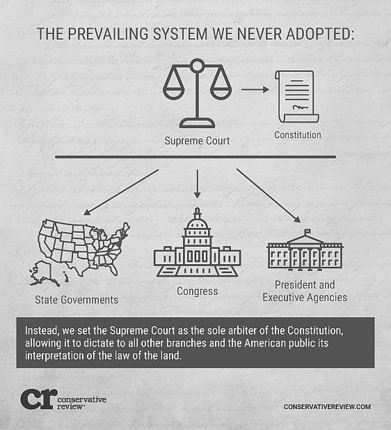
Since then, Republicans have sought to tamp down on the Supreme Court’s power, filing bills to impeach Democratic justices and force them to run in regional, partisan districts that would be drawn by the legislature.
Sen. David Argall (R., Schuylkill), whose State Government Committee will consider the congressional map before it gets to Wolf’s desk, said in an April 13 interview with Berks Community Television that he’s still hoping for bipartisanship in the redistricting process.
“I would much rather us work on this in a bipartisan spirit than for us to just throw our hands up and say, ‘Let’s let the Supreme Court do it,’” he said.

Pennsylvania Ping!
Please ping me with articles of interest.
FReepmail me to be added to the list.
Draw it but you can only draw 4 lines
Sure, just turn it over to the 6 D/3 R PA Supreme Court.
I’m sure they’ll be objective and apolitical.
/s
Excuse my ignorance in this matter. Is it really the case that it must be approved by the governor? Doesn't the US Constitution give the sole power to state legislatures? Obviously, the US Constitution never mentions any role or power to redistricting to state supreme courts.
Court drawn maps are how the Democrats took over Virginia.
Yes, the current map which was drawn by a California professor hired by the PA Supreme Court is entirely illegal per the Constitution of the US!
You forgot the sarcasm tag. Be glad I know you. LOL. I might have mistaken you Humblegunner or someone else.
There should be a process. Someting like:
1) Divide the state population by the number of districts to create the population target.
2) Create a list of all counties sorted by population - call this the working list.
3) Start with the county that has the largest population and then go to the largest City in that county
4) Draw an initial circle large enough to encompass the population per district
5) Subtract that total from the working population of that county/city
5) Then go to the next largest and draw another circle, minimizing overlap of circles
6) Once you are down to the last two districts, split the remaining area.
7) now go back and adjust the boundaries so that they are ligned first with roads.
8) add up the numbers for each proposed district. Should be within plus/minus 5 percent of the target from step #1
9) If all districts are within the target number, then we are done.
10) If a district is over population target, then adjust the boundary by shifting in the direction of the least population neighbor(s)
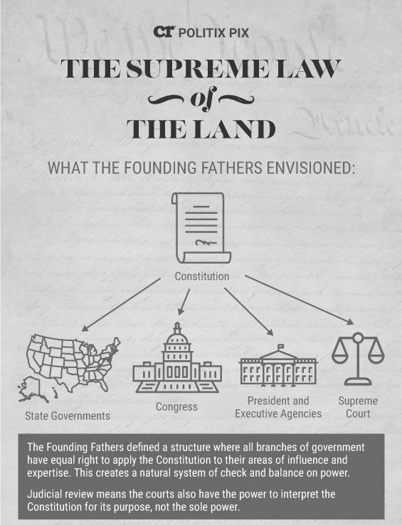
It’s so curious that many people believe the courts can supersede the Constitution when it is convenient for them.
If any body other than the PA state Legislature changes any provisions of the state election law, it should be sued into oblivion...
Sorry about the double post.
I have no idea why it happened?
Disclaimer: Opinions posted on Free Republic are those of the individual posters and do not necessarily represent the opinion of Free Republic or its management. All materials posted herein are protected by copyright law and the exemption for fair use of copyrighted works.