Free Republic
Browse · Search
News/Activism
Topics · Post Article

To: Red Badger
A twitter account posted an image of the Bahamas, saying the yellow lines indicate where the coast line 'used to be'.


https://twitter.com/CheyneJoness/status/1168959532464316416?ref_src=twsrc%5Etfw%7Ctwcamp%5Etweetembed%7Ctwterm%5E1168959532464316416&ref_url=https%3A%2F%2Fwww.democraticunderground.com%2F100212434322


14 posted on 09/03/2019 1:27:00 PM PDT by ransomnote (IN GOD WE TRUST)
[ Post Reply | Private Reply | To 12 | View Replies ]


To: ransomnote

PR and the Bahamas luck ran out.

They are in prime spots to get clobbered and it was only a matter of time.

I hope they can recover.


18 posted on 09/03/2019 1:29:14 PM PDT by ltc8k6
[ Post Reply | Private Reply | To 14 | View Replies ]

To: ransomnote

Probably during the storm surge. Most of that will recede.


25 posted on 09/03/2019 1:34:46 PM PDT by al_c (Democrats: Party over Common Sense)
[ Post Reply | Private Reply | To 14 | View Replies ]

To: ransomnote

I fear that the death toll will be huge.

I pray that I’m wrong.......................


29 posted on 09/03/2019 1:43:42 PM PDT by Red Badger (Against stupidity the gods themselves contend in vain......................)
[ Post Reply | Private Reply | To 14 | View Replies ]

To: ransomnote

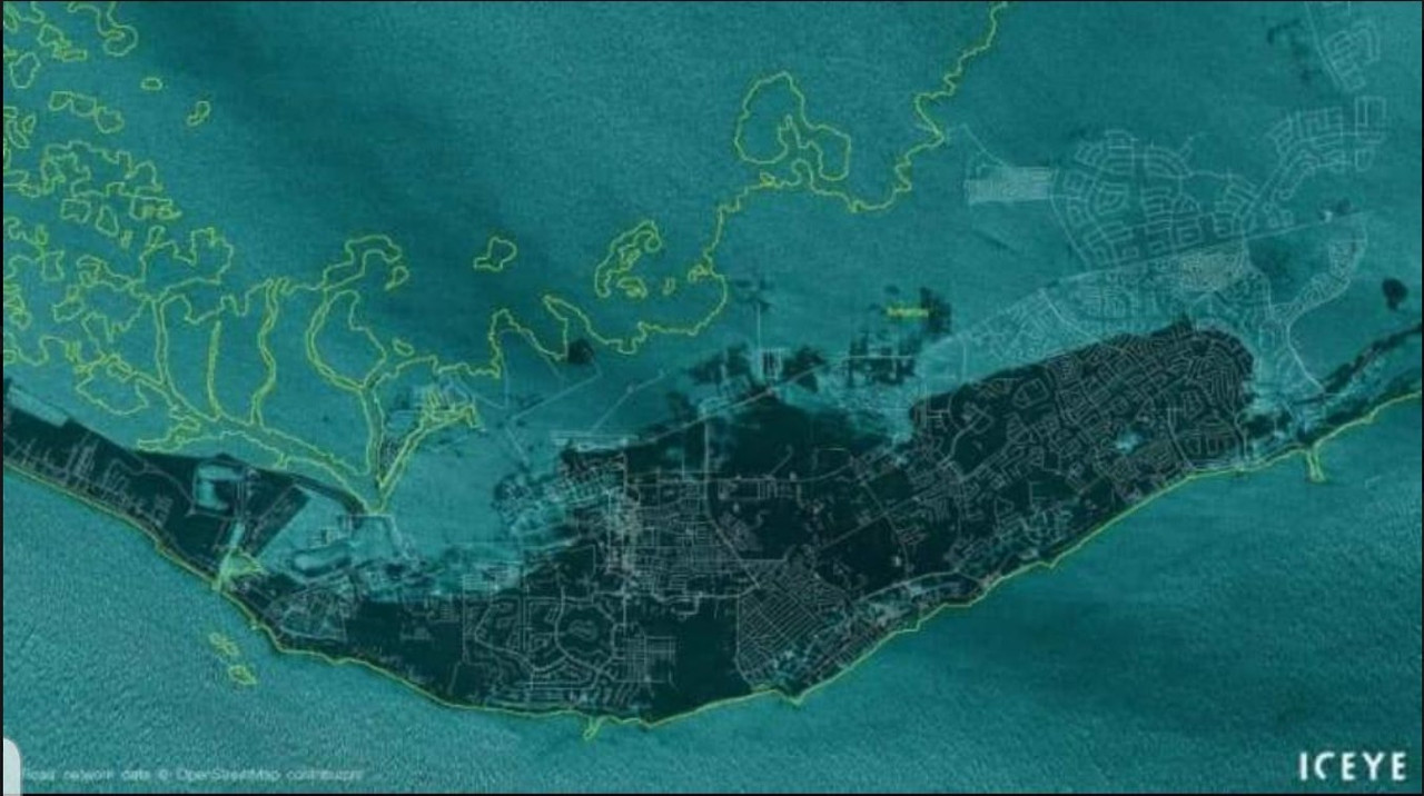
“A twitter account posted an image of the Bahamas, saying the yellow lines indicate where the coast line ‘used to be’.”

I was wondering about how the coastline would fare. A cat 5 sitting on top of an island for a day was bound to erode the beaches.
Looks like half the landmass is gone.


36 posted on 09/03/2019 1:51:58 PM PDT by oldvirginian (Winning isn't everything, it's the ONLY thing. TRUMP 2020!!)
[ Post Reply | Private Reply | To 14 | View Replies ]

To: ransomnote

Oh my goodness.


46 posted on 09/03/2019 2:08:30 PM PDT by KC_Lion
[ Post Reply | Private Reply | To 14 | View Replies ]

To: ransomnote

I have no words. Reminds me of the Tsunami. Praying for humanity to assist however we can.


62 posted on 09/03/2019 2:29:07 PM PDT by SueRae (An administration like no other.)
[ Post Reply | Private Reply | To 14 | View Replies ]

To: ransomnote

That was a satellite extrapolation of the current water levels on Grand Bahama Island during the storm surge as Dorian sat just north of the island. The yellow line is the normal coastline, the blue showing the storm surge that swamped most of the island.


126 posted on 09/04/2019 7:49:47 AM PDT by kingu (Everything starts with slashing the size and scope of the federal government.)
[ Post Reply | Private Reply | To 14 | View Replies ]

To: ransomnote

twitter account posted an image of the Bahamas, saying the yellow lines indicate where the coast line ‘used to be’.
***************************************

Where the coast “used to be” and where it will be again (for the most part) when the storm surge and flood waters recede.


138 posted on 09/05/2019 7:08:10 PM PDT by House Atreides (Boycott the NFL 100% — PERMANENTLY)
[ Post Reply | Private Reply | To 14 | View Replies ]

Free Republic
Browse · Search
News/Activism
Topics · Post Article


FreeRepublic, LLC, PO BOX 9771, FRESNO, CA 93794
FreeRepublic.com is powered by software copyright 2000-2008 John Robinson