Posted on 12/05/2018 7:07:30 PM PST by ProtectOurFreedom
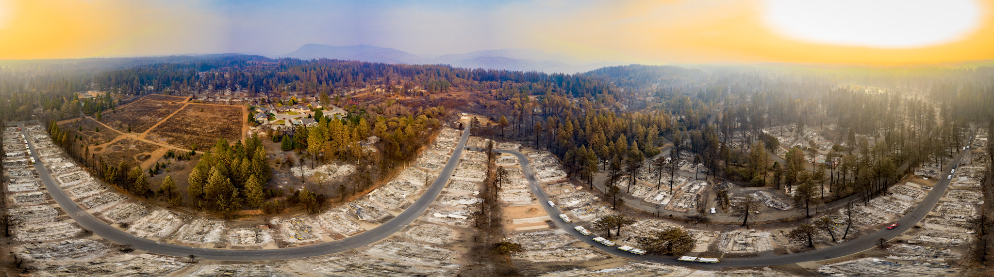
The Camp Fire ripped through 153,336 acres of Northern California over 17 days in November, demolishing more than 13,000 single-family homes and killing 88 people as of Monday. ...Newly-released photography and drone footage brings the devastation of what’s now known as the deadliest and most damaging wildfire in California’s history into sharp, visceral focus.
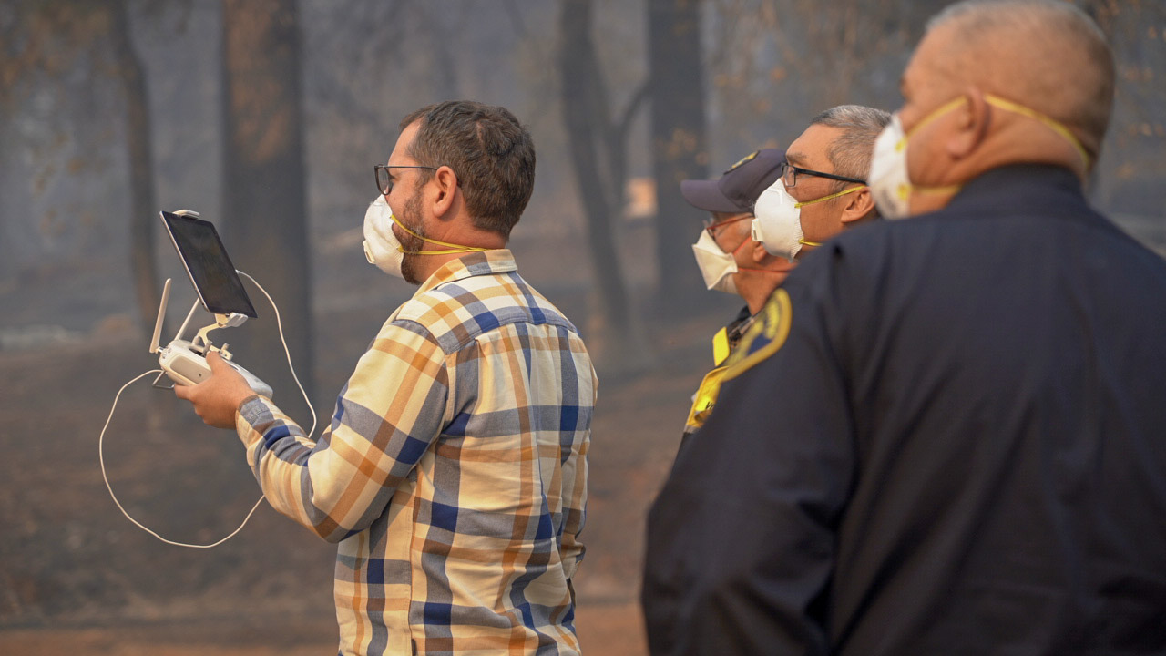
Drone engineer Greg Crutsinger, alongside 16 teams of Northern California law and fire departments and task forces of public safety drone operators, captured the destruction in aerial shots and 360-degree panoramas of what’s left of Paradise, California. The teams performed 518 drone flights in smoky conditions, capturing more than 70,000 images, including 160 panoramas. The data totaled around 477 gigabytes across two hard drives. Most of the town was mapped down to a one- or two-inch resolution. To get the information to fire control authorities as quickly as possible, runners brought the hard drives from agency to agency to help with recovery efforts, and were able to process the images within 24 hours of capturing.
You can view the footage on the Butte County website as an interactive map, or in Mapbox.
“Basically we pulled off the impossible... and I'm really tired,” Crutsinger told me in an email.
Crutsinger provided volunteer drone photography work with fire prevention authorities in the Carr Fire earlier this year, and the wildfire that ripped through the Coffey Park neighborhood of Northern California in 2017. As in those cases, his images and data collected from the Camp Fire will be used to better understand how fires behave and spread, and how to better contain and recover from them in the future.
(Excerpt) Read more at motherboard.vice.com ...
 am i the only one that doesn't understand how ALL the houses can be burnt to the ground, nothing but ash and all the trees left standing???
Good point.
I just watched a documentary on the explosion of the volcano Krakatoa in 1883...the interesting thing about it from a technology standpoint was that it the first disaster known around the globe almost at the time it happened because of the telegraph sending news of it worldwide.
Same with the Vietnam war, and how that changed coverage of war because it was shown in real time for the first time in history.
Twice the caffeine and sugar, half the calories.
The trees held moisture (water) in their cells, the homes did not.
even the leaves dint burn... doesn’t seem they could hold that much water and not dry out/burn when the fires burnt tile roofs
California,,,
Shake and Bake.
It’s been explained and attributable to ground cover, primarily..... and flammable building materials.
Nope, you're not the only one. Lots of people have been asking the same question.
*Did tile roofing in the 70'...1000# per square. Plumbers not putting out their fires when sweating pipes burned three of our houses.
Firemen do not want to go under a tile roof.
Then why do whole forests of trees burn down in forest fires?
It’s rather simple. Academic in fact:
The town was poorly-planned. Built in the wildland. Literally. For the most part, this was not a crown fire wildfire: It was a ground cover firestorm driven by wind.
This town was built in a fire area with negligent building codes and planning which placed not only the structures too close together, but without buffers to vegetation (defensible space). Furthermore, the town itself had no defensible space, an tragedy waiting to happen.
If you search for it, you will find evidence of homes which survived that, either by chance or design, met the criteria to have a shot at surviving this type of fire.
This was a man-made disaster and it had nothing to do - just for clarity’s sake - with CO2.
Think Texas back in '11.
We call them Wildfires.
I read the winds were so strong and blowing the flames and embers sideways. They blew so fast below the crown of the trees that the trees wouldn’t catch fire.
But - they blew straight into the next house, and embers piling up along the base of the house.
Effectively, three separate fires swept through Paradise.
First was the ground fire - fed by dense ground cover. Second was a tree to tree fire - extremely hot and some homes ignited from the radiated heat. The third was fed by sputtering building fires and high winds.
But something to keep in mind (and feel free to go browse Google Map’s street view to see what it looked like before the fire...) You’re seeing maybe one in twenty trees still standing. There were tens of thousands of young trees in that town (that grew after the 2008 fire...) Some properties would have 80-120 trees on a quarter acre plot, with heavy ground cover as well.
And lastly, after about 9am on the morning of the fire, firefighting pretty much ended. All firefighters, police, etc were directing traffic, protecting people sheltering from the flames, rescuing people from the flames, etc. Bulldozers which would normally knock fuel out of the path of the fire were clearing roads of burning cars.
And meanwhile, thousands of people were in gridlock on Skyway trying to leave Paradise, Magalia and points up the ridge.
Actually, it was a ground fire, a crown fire, and a massive structure fire as the day progressed. The amount of papers that could be written about just the fire’s behavior will be numerous, not to mention highlighting the Butte County Grand Jury’s finding in 2008 that there was significant risk, and the city of Paradise’s reply that they’re the most prepared ever.
And then they reduced the critical emergency evacuation route from 4 lanes to 2 to put in bike lanes and street parking.
if the trees had been given "cowboy haircuts" which is trimming all the low branches off, the fire could have burned some of the trunk and moved on....
“Some properties would have 80-120 trees on a quarter acre plot...”
After the fire I was talking to a friend in California. He said he did a job in Paradise years ago. That is the first thing he noticed was all of the trees in among the homes, and that it would be a death trap when a fire came through.
He almost was going to find another hotel out of town it freaked him out so much. “But I figured - what are the odds? I should have just found another place. I never did get a decent night’s sleep there thinking about it.”
I’m not going to argue your point, the wind being the principal variable.
But I think we’re on the same page.
Make a print and attach it to a picture of Jerry Brown.
Disclaimer: Opinions posted on Free Republic are those of the individual posters and do not necessarily represent the opinion of Free Republic or its management. All materials posted herein are protected by copyright law and the exemption for fair use of copyrighted works.