
Posted on 09/09/2018 8:01:18 AM PDT by NautiNurse
September 10 is the statistical peak of the Atlantic Tropical Storm season, and the conga line of storms dancing across the Atlantic is not disappointing historical data. The Governors of NC and SC have declared states of emergency for a potential major hurricane landfall, while Hurricane Florence is slowly creeping westward. Florence is predicted to increase forward motion and intensity Monday. Hurricanes Hazel (1954) and Hugo (1989) are two notorious major hurricanes to make landfall in NC and SC, respectively. North Carolina has prior experience with "F" named hurricanes. Hurricanes Fran (1996) and Floyd (1999) caused widespread flooding and damage in the Tar Heel state.
The NHC has been issuing Public Advisories for Florence since August 30. The five day "Cone of Uncertainty" archive progression since Aug. 30 may be found here.
Isaac is a small storm. Isaac is predicted to steadily strengthen during the next few days as the storm remains over warm waters and in a low wind shear environment in the short term. The NHC predicts Isaac will reach hurricane status within 2 days.
Helene is expected to reach hurricane status in the short term. However, Helene is not anticipated to threaten U.S. interests. The forecast track turns north into the mid-Atlantic.
Click on the images below to enlarge

Stay safe. I hope traffic is light!!
If it helps, the pics are from the bottom of the hill in the downtown historic area. If you are familiar with Elliott City, Md. they will probably take another beating too.
Thanks much!
The condo in Annapolis in on Back Creek but it’s on the 3rd floor. Will no doubt lose power but there is a gas stove.
We can sit on the deck and watch the creek flood I guess. Last time it got really bad a few people didn’t add enough slack to their tie lines and their boats sank. Oops.
I figure if I leave Wilmington at 2 am I should get to Annapolis by 10 or 11 am. Only a 6 1/2 drive but I’m sure it will take longer.
Maybe I should change plans and head for St Augustine instead. LoL
Periscope depth = 62 feet.
Funny how you remember small things like that from 50+ years ago.
w euro model crazy stalls off near Wilmington then moves SW right along the coast to almost savanna ga in two days then moves to Atlanta
No doubt, there will be lots to take infrom the 3rd floor!
Just know you’ll have a fellow Freepwr in HoWard County about 30 minutes away. Send me a message anytime.

Here’s an earlier video from the National Gurricane Venter
https://www.facebook.com/NWSNHC/videos/2247448232177305/
National Hurricane Center
Please accept my apologies for not checking the spelling.
New operational run just in hot off the presses Is different
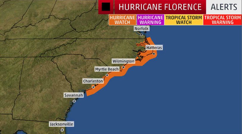
Issued from Edisto Beach, SC to NC/VA border, including Charleston,
Myrtle Beach and the Outer Banks
Spagetti tracking is always changable....
UPDATE, 2p:
Florence is getting BIGGER and better organized says NHC_Atlantic.... Hurricane-force winds now expand 60 miles from center (from 40 miles earlier). Peak winds still at 130 mph but likely to increase.
South Carolina and North Carolina have all declared states of emergencies.


Probably just climate change
Good to know!! Stay safe, will chat soon!
Reservations was a loose term. Arrangements might be a better one.
Hydrology can be an exact science, if you have access to supercomps and Digital Elevation Models, IF you know in advance exact rainfall amounts and placements.
I have plenty of CPU and DEMs but I don’t have a crystal ball on the rainfall variable, so I’d line me up some alternatives.
Our hummers in Upstate SC usually depart around September 20th but seem to have departed yesterday in advance of the storm. Smart critters

Disclaimer: Opinions posted on Free Republic are those of the individual posters and do not necessarily represent the opinion of Free Republic or its management. All materials posted herein are protected by copyright law and the exemption for fair use of copyrighted works.


