Free Republic
Browse · Search
News/Activism
Topics · Post Article

To: WildHighlander57; kristinn; LucyT; hoosiermama; crosslink; Black Agnes; SatinDoll; null and void
http://www.bigbreakingnews.com/2014/03/luggage-found-floating-at-sea-possibly.html#.UyXU8dwvtFL

Luggage found floating at sea, possibly from Flight 370, by Elka Athina

Crew on a Greek flagged oil tanker are responding to radio reports of suit cases found floating in the Straits of Malacca, between Malaysia and Indonesia, Greek media reported.

The Oil and chemical tanker, the Elka Athina, reported to media that it was steaming toward a zone identified as a field of debris, including what appeared to be aircraft passenger's luggage.

The crew was responding to a report from an Indonesian source, according to the translation of the report.

That's according to two articles published Sunday afternoon Greek time.

The report was not confirmed by any other sources, however one Greek website posted an audio interview with the Elka Athina’s first officer confirming the ship was headed to an area after the report of suit cases floating in the northern waters of the Malacca Strait.

There have been several false sightings of debris since Malaysian Airlines Flight 370 went missing over a week ago, including a Chinese satellite image of debris in the south China Sea and reports of an oil slick off Vietnam. All proved to be unrelated to the missing 777-200.

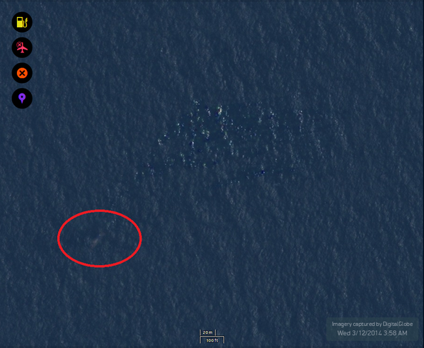
Update: It appears a Reddit user found images of possible wreckage at the exact location of the Greek report in the Malacca Strait. An image of a debris field was seen on high resolution satellite images provided by a US firm in an attempt to find the missing 777-200.

The area is also about the same point where Malaysia last lost verifiable data on the location of MH370 on Saturday, March 8 2014.

More to come.

Image from Reddit via satellite firm of same area


37 posted on 03/16/2014 9:46:50 AM PDT by maggief
[ Post Reply | Private Reply | To 13 | View Replies ]


To: maggief

Uh oh...

Looks like they may have located the crash site.


39 posted on 03/16/2014 9:48:29 AM PDT by Cringing Negativism Network ( http://www.census.gov/foreign-trade/balance/c5700.html#2013)
[ Post Reply | Private Reply | To 37 | View Replies ]

To: maggief
That is from the Tomnod digital satellite image crowdsourcing search effort.

Tomnod Map ID:
http://www.tomnod.com/nod/challenge/malaysiaairsar2014/map/128148

Location:
https://www.google.com/maps/place/5°39'08.5"N+98°50'38.0"E
44 posted on 03/16/2014 9:52:52 AM PDT by xeno
[ Post Reply | Private Reply | To 37 | View Replies ]

To: maggief

Isn’t it 1am there? Going to be a little hard to see anything til morning


47 posted on 03/16/2014 9:57:03 AM PDT by Bulwinkle (Alec, a.k.a. Daffy Duck)
[ Post Reply | Private Reply | To 37 | View Replies ]

To: maggief

Where is this image from please?


79 posted on 03/16/2014 10:57:44 AM PDT by Cringing Negativism Network ( http://www.census.gov/foreign-trade/balance/c5700.html#2013)
[ Post Reply | Private Reply | To 37 | View Replies ]

To: maggief

Have you noticed that the visible white “speckles are at the tops of the swells and there is nothing in the troughs? Microburst whitecaps...


118 posted on 03/16/2014 10:32:57 PM PDT by Birdsbane ("Onward through the fog!" ... Oat Willie)
[ Post Reply | Private Reply | To 37 | View Replies ]

Free Republic
Browse · Search
News/Activism
Topics · Post Article


FreeRepublic, LLC, PO BOX 9771, FRESNO, CA 93794
FreeRepublic.com is powered by software copyright 2000-2008 John Robinson