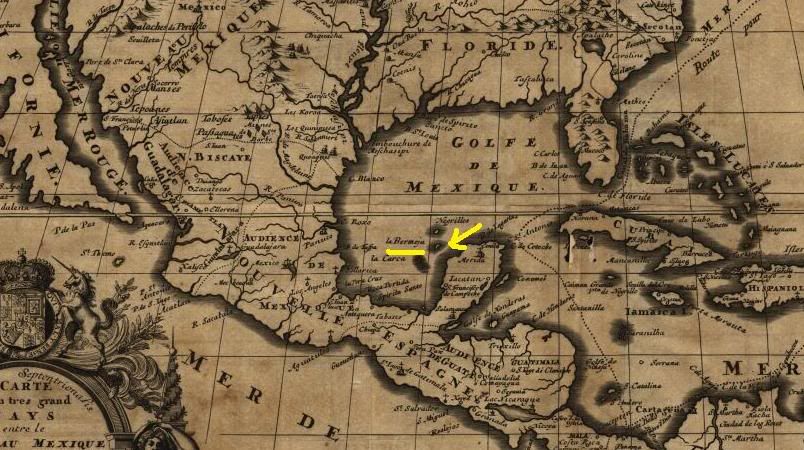
 If the yellow arrows point to the right island, it wouldn't change anything, as there are other islands farther offshore from Mexico.
Posted on 06/24/2009 3:15:24 PM PDT by SwinneySwitch
MEXICO CITY — Mexico vowed to keep looking for a mysterious island that could extend its offshore oil claims after university researchers said they couldn't find it.
"The island doesn't exist" in the area where it was shown on maps, a National Autonomous University of Mexico study concluded after conducting studies with underwater sensing devices and aerial reconnaissance in the area.
"Isla Bermeja" appeared on maps from the 1700s as a speck of land off the northwest coast of the Yucatan peninsula. A group of Mexican legislators hoped the island would help their decade-long effort to fend off what they describe as U.S. encroachment on their nation's oil claims in the Gulf of Mexico.
Bermeja had been shown lying farther off Mexico's coast than other, confirmed islets, possibly extending the nation's claim by about 55 nautical miles into an area in the middle of the Gulf that lies between U.S. and Mexican territorial waters, said Elias Cardenas, the head of Mexico's congressional Maritime Committee.
That area, which lies beyond both countries' 200-mile territorial limits, is believed to hold rich oil deposits under the sea floor.
Cardenas said he hopes to explore other spots where the island might lie, and plans to ask for more funding for oceanographic studies to help solve the mystery.
"There are four other possible sites where it might have been," Cardenas said, referring to versions the island might have sunk or been submerged.
He said the matter was urgent because the two countries are expected to formalize an agreement on drilling rights in the area soon. "Right now, the big fight is for oil," he said.
How an island could have been listed where none existed remains a mystery, though old maps often carried over inaccurate information from earlier charts.
(Excerpt) Read more at latimes.com ...
Ask Algore where it is. I think that globull warming took it due to rising sea levels.
Texas took it.
With today’s satellite technology (or even from the 70s), this should be a resolved issue.
How do you say ‘Fantasy Island’ in Spanish?
From a 30,000 foot flyover view on Google Earth, the name of the island sometimes pops up on Google Earth. If you zoom in on that spot, at some point the name of the island disappears, and you're looking at open water in the Gulf of Mexico.
Very strange.
Even if it exists, why should Mexico be allowed to claim it?
Isla de la Fantasía
The plane! The plane!
If you want on, or off this S. Texas/Mexico ping list, please FReepMail me.
 If the yellow arrows point to the right island, it wouldn't change anything, as there are other islands farther offshore from Mexico.
Since our government has nixed off-shore drilling, and Cuba is cooperating with Venezuela and China in off-shore dwelling projects, it seems to me that Mexico ought to be more worried about the communists than the Americans.
Cool...i think i will claim an island, declare it a country then claim oil reserves!
The USA got lots of non existent islands in Lake Superior from Great Britain/ Canada, then Michigan got them as a means of appeasing us so we wouldn’t fight over Toledo. (We got the better end of that deal)
Someone dropped a bread crumb then rolled up the map - ain’t no island.
Flyspot Island.
Well, in the 1700s, maps were showing California as an island. Up until Lewis and Clark’s expedition, there were many learned people who thought that there was a Northwest Passage, wherein one could sail from the Atlantic to the Pacific. Part of L&C’s mission was to prove or disprove that belief.
Lots of hearsay or speculation in those old maps.
The island snuck across the Arizona border and is working as a landscaper under an assumed identity.
I claim ownership to the large island off Florida. I will call it Daveland.
Has anyone asked Ben Linus?
Yes ask Al. This is so Mexico on so many levels!
Disclaimer: Opinions posted on Free Republic are those of the individual posters and do not necessarily represent the opinion of Free Republic or its management. All materials posted herein are protected by copyright law and the exemption for fair use of copyrighted works.