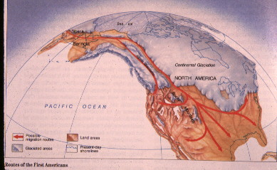
The lower drawing shows the extent of the ice. It was not as extensive as you might suspect.
Hope this helps.
It could also be that many of the areas of denser population in that time are now under water.
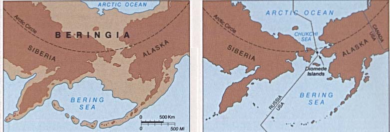
I still have problems when trying to understand the Bering Sea Bridge thing. I admit to no education in the subject area so it’s all pure guess on my part, but...
The Bering Sea loc vic where the bridge is supposed to have been is clogged with ice during winter now, and it’s not an ice age.
If the ice sheets were thick enough to cover the top half of the North American continent, then the ice cap at sea must have been equally large and extended. The ice cap on land at the other side of the bridge would be down past the bridge entrance as well.
This would seem to me to mean that any migrating critters and/or peoples would have had to climb up on the huge, barren, lifeless and wildly dangerous ice cap, travel all the way along that ice cap to where it crossed the sea, all the way across the sea, and all the way down the other side of the ice cap.
All that, instead of moving south away from the ice where there was such luxuries as food, shelter, unfrozen water, and at least some potential for survival.
Now, if the sea was 200m or so shallower due to all that ice, how much closer would the shores, and how much more prominent would the various islands along the way have appeared to be?
The lower drawing shows the extent of the ice. It was not as extensive as you might suspect.
Hope this helps.
No, it's not. And it never has been, as far as we can tell.
Glaciers only form on land and mostly are funneled through existing land mass further deepening and widening the path of least resistance, which we'd normally consider valleys although that's not quite accurate.
The land bridge when exposed would have been essentially ice-free. The polar sea ice cap won't form on land, and icebergs don't wash ashore. Glaciers take thousands of years to form given proper precipitation.
None of that would apply to the land bridge.