Posted on 05/25/2008 4:13:37 PM PDT by janetjanet998
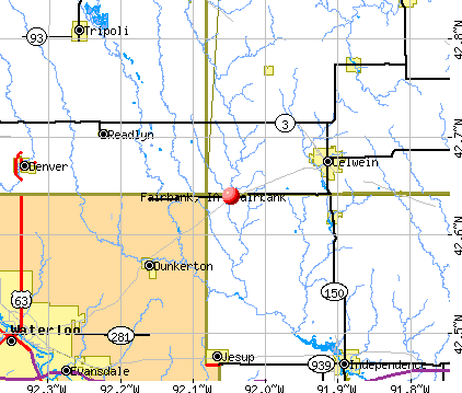
AT 6:01 PM CDT, SHERIFF’S DEPARTMENT REPORTED 1/2 MILE WIDE TORNADO MOVING EAST INTO FAIRBANK IA
COON RAPIDS, Minn. (AP) - A high-powered line of storms is sweeping across the north metro area, with tornadoes reportedly touching down in the Twin Cities suburbs of Coon Rapids and Hugo.
No injuries were immediately reported. But there were reports of significant damage from tornadoes, high winds and large hail stretching from Albertville in the northwest across to Coon Rapids and through Hugo.
Hugo appears to be the hardest hit. Residents reported a tornado damaging multiple homes along Highway 61. Xcel Energy says about 45-hundred customers are without power.
The storm also was carrying damaging hail. Residents in Albertville reported west-facing windows on houses and vehicle windshields being shattered by large hail.
A TORNADO WARNING REMAINS IN EFFECT UNTIL 645 PM CDT FOR BUCHANAN
COUNTY...
AT 607 PM CDT...TRAINED SPOTTERS REPORTED A TORNADO ON NORTHEAST SIDE
FAIRBANK WITH BASEBALL SIZE HAIL...MOVING NORTHEAST AT 35 MPH.
A SECOND TORNADO WAS WEST OF FAIRBANK MOVING EAST AT 32 MPH.
This probably needs to be moved to chat, it might distract people from the importan Hulk Hogan car crash story.
/sarcasm off
Prayers up for those in the path as we have em bouncing around us here in the Texas Panhandle right now as well........
PING PONG
Thank you! Where did you get the above info? By listening to a scanner? The local news does not have this info yet.
What is “full code”?
They’re doing live streaming.
Just said that someone called and said the southern part of Parkersburg is pretty much gone. Someone in another county (Bremer) found paper debris from Parkersburg. “
Thanks, Janet. I’m trying to contact friends in both IA and MN right now. No luck, but they weren’t in the direct path, at least.
We have nasty stuff heading our way right now into southern Wisconsin. Our weather radio just went off, so we’re assessing the situation.
Keep a good thought for us, too!
It means they need all possible first responders on scene to do all possible to save lives.
I was just looking at that. Be safe FRiend.
SEL3
URGENT - IMMEDIATE BROADCAST REQUESTED
TORNADO WATCH NUMBER 363
NWS STORM PREDICTION CENTER NORMAN OK
330 PM CDT SUN MAY 25 2008
THE NWS STORM PREDICTION CENTER HAS ISSUED A
TORNADO WATCH FOR PORTIONS OF
A LARGE PART OF IOWA
EFFECTIVE THIS SUNDAY AFTERNOON AND EVENING FROM 330 PM UNTIL
1000 PM CDT.
...THIS IS A PARTICULARLY DANGEROUS SITUATION...
DESTRUCTIVE TORNADOES...LARGE HAIL TO 3 INCHES IN DIAMETER...
THUNDERSTORM WIND GUSTS TO 80 MPH...AND DANGEROUS LIGHTNING ARE
POSSIBLE IN THESE AREAS.
THE TORNADO WATCH AREA IS APPROXIMATELY ALONG AND 75 STATUTE
MILES NORTH AND SOUTH OF A LINE FROM 60 MILES SOUTHWEST OF FORT
DODGE IOWA TO 50 MILES EAST SOUTHEAST OF CEDAR RAPIDS IOWA. FOR
A COMPLETE DEPICTION OF THE WATCH SEE THE ASSOCIATED WATCH
OUTLINE UPDATE (WOUS64 KWNS WOU3).
REMEMBER...A TORNADO WATCH MEANS CONDITIONS ARE FAVORABLE FOR
TORNADOES AND SEVERE THUNDERSTORMS IN AND CLOSE TO THE WATCH
AREA. PERSONS IN THESE AREAS SHOULD BE ON THE LOOKOUT FOR
THREATENING WEATHER CONDITIONS AND LISTEN FOR LATER STATEMENTS
AND POSSIBLE WARNINGS.
OTHER WATCH INFORMATION...CONTINUE...WW 357...WW 358...WW
359...WW 360...WW 361...
DISCUSSION...VERY TO EXTREMELY UNSTABLE AIR MASS ACROSS MUCH OF IA
AHEAD OF COLD FRONT. THUNDERSTORMS WILL DEVELOP RAPIDLY AND WITH
STRONG DEEP LAYER SHEAR QUICKLY BECOME SUPERCELLS. VERY LARGE HAIL
AND TORNADOES ARE LIKELY WITH ANY SUPERCELL. POTENTIAL FOR LONG
LIVED SUPERCELLS WITH STRONG TORNADOES.
AVIATION...TORNADOES AND A FEW SEVERE THUNDERSTORMS WITH HAIL
SURFACE AND ALOFT TO 3 INCHES. EXTREME TURBULENCE AND SURFACE
WIND GUSTS TO 70 KNOTS. A FEW CUMULONIMBI WITH MAXIMUM TOPS TO
550. MEAN STORM MOTION VECTOR 24035.
I knew there were going to be lots of tornadoes. We had 2 inches of snow yesterday along with 60 mph winds. When that cold air hits the warm moist air, it’s a dangerous situation. That 1/2 mile wide one is massive. Prayers go out for all those affected.
Many thanks to the mods for leaving this in Breaking News.
How strange...yesterday’s “Breaking News” postings of tornadoes in OK were quickly moved to chat. We were told that FR isn’t the Weather Channel by one of the Mods. Now, all pings to that particular thread are gone.
i grew up in a town near fairbank
Disclaimer: Opinions posted on Free Republic are those of the individual posters and do not necessarily represent the opinion of Free Republic or its management. All materials posted herein are protected by copyright law and the exemption for fair use of copyrighted works.