Posted on 12/21/2005 4:36:05 AM PST by lemura
SAN DIEGO -- Lifeguards Tuesday prepared for waves up to 18 feet that are expected to arrive Wednesday. "We've increased our staff a little in anticipation of the high surf and we're doing a bit of predeployment in the rescue-prone areas," said San Diego Lifeguard Lt. Greg Buchanan. Eight lifeguards will be on duty at daybreak Wednesday, and a special unit will be in place at Sunset Cliffs, he said.
(Excerpt) Read more at cbs13.com ...
Cool...
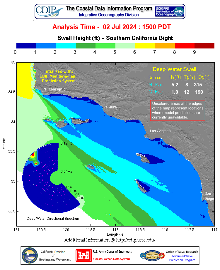
Wednesday the 21st, the shortest day of the year, will be seeing some big surf hit the coast. As we’ve mentioned in our reports since last week, this is from a significant WNW system that’s been traveling at low latitudes towards our region. The interesting thing about this system is that its fetch has been moderately sized with 30-35 foot seas. This isn’t really all that big for a Pacific ground-swell-generating storm; it is though when you consider its proximity. This storm is now (Tue. 6:00 AM) only 600 nautical miles offshore, located at a low latitude of around 30-35N. Most systems traveling through the Pacific either turn northward before nearing the California coast and/or lose a lot of strength once passing the Hawaiian Islands; but this system broke from convention, and its fetch has not diminish. This means we’re in for a direct hit from this system.
Traveling at such a low latitude, the incoming angle on this one will be direct west (270) in SoCal, and it may even bring in some energy from 260+. This means south facing breaks have a good chance of seeing more diffraction than normal. West facing breaks in any event will be seeing some heavy, consistent surf.
The biggest swath of long-period swell will be temporary, and here’s how we’re calling it today:
On Wednesday morning, pre dawn, size around west facing beaches should be around 10-12 feet on the faces. By mid to late morning, face heights should easily reach 15 feet. Then the biggest portion of the swell is due late morning to early afternoon with face heights reaching 18 feet, possibly 20+ feet by noon.
Note that this is based on best-case scenarios for west facing beaches not affected by island blockage. With this in mind, some areas of Ventura and Orange County could likely see some smaller size. Also, this swell will have some long, 14-16 second periods, so there will inevitably be some variation in size between west facing breaks depending on the bathymetry of each surf spot, and its corresponding shoaling and refraction properties. In any case, such an intense system is one to be approached with caution at all beaches along the coast, no matter what direction they face. Besides the potential for bone-crushing, board-snapping forces that could result in heavy, long hold downs, the risk of riptides and alongshore currents is extremely high. Caution is strongly advised. Please also note that the NWS has issued high surf and coastal flooding warnings for the entire California coast.
There’s also couple of other things to consider about this swell. First, the incoming angle, being some direct west could result in a lot of closeouts. Also, the consistency may be high enough to create backwash and washing machine conditions in some areas. Winds are the second concern. Although winds should remain lightly offshore during the morning, strong WNW winds are expected late afternoon, lingering into Thursday and Friday with an onshore flow.

DARN Cool, dude. I'm headed out today with the camera and will go to HB pier!!!!!
HB pier southside was epic Mon am. I bailing from work and going up to PV.
COWABUNGA!

If you can, please post some pictures and ping me.
Seal Beach was incredible on Sunday. On the south side of the pier waves were coming in from two directions, often breaking on bare beach! The belly boarders were catching some incredible curls further out.....
KAWABUNGA! Putting on Dick Dale's Greatest Hits CD!
My son must be beside himself. He flew to San Clemente on Monday, to visit his brother, hoping to do some surfing.This is a guy who surfs the coast of MA. Maine and R.I. in January.
 Caption: One tiny dot shows one person out at Cable cars today - 12ft
If you look at the projection in #4, you can see that Catalina blocks San Clemente on direct west swells (ie 270 degrees). He's probably loading up the car as I type getting ready to drive the quick 30 miles south to north SD county - see those red dots around Cardiff?
I've seen the RI coast in January, right outside the mouth of the bay. 40 foot cliffs to the edge, and CCCCCOLD water there!
Being a FL boy, I didn't go swimming! If it isn't 80 degree water, you can have it.
I miss the Rhode Island surf! Best on the east coast if you don't mind the 30-degree water. I used to go to URI and had a little cottage about a mile from about half a dozen spectacular point breaks.

Surfing in January or February would be the only thing that could get him out of bed ,in the dark, at 4 AM. He would go surfing and then head to work.
My husband who surfed in the late 60's and early 70's didn't know what a monster he would create when he introduce my sons to surfing. My poor daughter, every vacation we took as a family had to have good surf as a requirement.

More Jolt, please...
I'll put some on my website, perhaps later today.
Disclaimer: Opinions posted on Free Republic are those of the individual posters and do not necessarily represent the opinion of Free Republic or its management. All materials posted herein are protected by copyright law and the exemption for fair use of copyrighted works.