Skip to comments.
Mars rover Spirit begins climb down from summit (of Husband Hill)
ap on Yahoo ^
| 10/24/05
| Alicia Chang - ap
Posted on 10/24/2005 5:52:42 PM PDT by NormsRevenge
click here to read article
Navigation: use the links below to view more comments.
first 1-20, 21-25 next last
To: NormsRevenge
And going....and going...and going....
2
posted on
10/24/2005 5:53:29 PM PDT
by
cripplecreek
(Never a minigun handy when you need one.)
To: NormsRevenge

This handout photo provided by NASA, taken by the Mars exploration rover Spirit, shows this 360-degree panorama of images taken with its navigation camera Friday, Oct. 7, 2005, of its exploration of Gusev Crater on Mars. This view is presented in a cylindrical projection with geometric seam correction. In this photo Spirit looks back at the long and winding trail of twin wheel tracks the rover created to get to the top of 'Husband Hill.' Spirit spent several days in October 2005 at this location, perched on a lofty, rock-strewn incline next to a precarious outcrop nicknamed 'Hillary.' To the west are the slopes of the 'Columbia Hills,' so named for the astronauts of the Space Shuttle Columbia. Beyond the hills are the flat plains and rim of Gusev Crater. (AP Photo/ NASA, JPL, CalTech)
3
posted on
10/24/2005 5:53:33 PM PDT
by
NormsRevenge
(Semper Fi ... Monthly Donor spoken Here. Go to ... https://secure.freerepublic.com/donate/)
To: NormsRevenge
Amazing longevity for these two craft. Wait till they get the one up there with a power pack that is supposed to last for years.LOL!
To: NormsRevenge
Way to go Rovers.
Hang in there and keep sending those pictures.
And they said you were only good for how long?
5
posted on
10/24/2005 5:56:11 PM PDT
by
PeteB570
(I think they are just like JJ and Al)
To: NormsRevenge
Mars rover Spirit begins climb down from summit (of Husband Hill) :

6
posted on
10/24/2005 5:57:06 PM PDT
by
Diddle E. Squat
(SonofaBuckner Qualls and Lidge, king and queen of Choke City, USA)
To: NormsRevenge
Two years and still running. New experiments are having to be devised to get the maximum benefit out of this bonanza of data.
7
posted on
10/24/2005 5:57:14 PM PDT
by
RightWhale
(Repeal the law of the excluded middle)
To: NormsRevenge
This is NASA at it's best. But of course, the people responsible for these outstanding images are being dismissed because of budget priorities.
There are times when I want to grab the NASA administration and shake some sense into them.
8
posted on
10/24/2005 5:57:30 PM PDT
by
Hunble
(Proud to be a SOLDIER'S ANGEL)
To: NormsRevenge
If you find anymore pics, post them!
Thanks!
9
posted on
10/24/2005 5:58:53 PM PDT
by
Black Tooth
(The more people I meet, the more I like my dog.)
Amazing little vehicles..

Looking Back at Spirit's Trail to the Summit
Before moving on to explore more of Mars, NASA's Mars Exploration Rover Spirit looked back at the long and winding trail of twin wheel tracks the rover created to get to the top of "Husband Hill." Spirit spent several days in October 2005 at this location, perched on a lofty, rock-strewn incline next to a precarious outcrop nicknamed "Hillary." Researchers helped the rover make several wheel adjustments to get solid footing before conducting scientific analysis of the rock outcrop. The rock turned out to be similar in appearance and composition to a rock target called "Jibsheet" that the rover had studied several months earlier and hundreds of meters away.
10
posted on
10/24/2005 5:59:38 PM PDT
by
NormsRevenge
(Semper Fi ... Monthly Donor spoken Here. Go to ... https://secure.freerepublic.com/donate/)
To: NormsRevenge
landed on opposite ends of the Red Planet Somebody 'splain to me how a (roughly) spherical planet has "ends"...
11
posted on
10/24/2005 6:00:18 PM PDT
by
Izzy Dunne
(Hello, I'm a TAGLINE virus. Please help me spread by copying me into YOUR tag line.)
To: Black Tooth; All
This is
Jibsheet
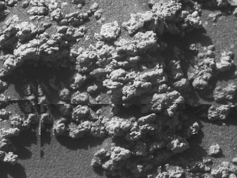
Original Caption Released with Image:
A bulbous texture is evident in this rock target at the outcrop called "Jibsheet" in this view from the microscopic imager on NASA's Mars Exploration Rover Spirit. Frames making up this mosaic image of a target dubbed "Reef" were taken during the rover's 481st martian day, or sol (May 11, 2005).
Image Credit: NASA/JPL/Cornell/USGS
12
posted on
10/24/2005 6:01:28 PM PDT
by
NormsRevenge
(Semper Fi ... Monthly Donor spoken Here. Go to ... https://secure.freerepublic.com/donate/)
To: All
Onto Haskin Ridge..

After Conquering 'Husband Hill,' Spirit Moves On
The first explorer ever to scale a summit on another planet, NASA's Mars Exploration Rover Spirit has begun a long trek downward from the top of "Husband Hill" to new destinations. As shown in this 180-degree panorama from east of the summit, Spirit's earlier tracks are no longer visible. They are off to the west (to the left in this view). Spirit's next destination is "Haskin Ridge," straight ahead along the edge of the steep cliff on the right side of this panorama.
The scene is a mosaic of images that Spirit took with the navigation camera on the rover's 635th Martian day, or sol, (Oct. 16, 2005) of exploration of Gusev Crater on Mars. This view is presented in a cylindrical projection with geometric seam correction.
Image credit: NASA/JPL-Caltech
13
posted on
10/24/2005 6:04:00 PM PDT
by
NormsRevenge
(Semper Fi ... Monthly Donor spoken Here. Go to ... https://secure.freerepublic.com/donate/)
To: Hunble
Yup, NASA is laying off folks due to budget priorities.. per this photo caption.

A file photo shows the 1997 Mars rover mission on the surface of Mars. The California space laboratory that guided NASA's Mars rover missions has begun laying off workers in anticipation of a budget shift away from planetary expeditions, a spokesman said on Thursday. (NASA/JPL/Handout/Reuters)
14
posted on
10/24/2005 6:06:41 PM PDT
by
NormsRevenge
(Semper Fi ... Monthly Donor spoken Here. Go to ... https://secure.freerepublic.com/donate/)
To: All
Meanwhile, on the other side of Mars,, Opportunity ..

Dodging the Drifts
This image taken by NASA's Mars Exploration Rover Opportunity is a portion of a mosaic acquired by the panoramic camera. The picture highlights the light-toned outcrop on the rim of "Erebus Crater" and large, dark, wind-deposited drifts that have filled the center of the crater. Opportunity took this image on the rover's 608th sol (Oct. 9, 2005). The rover is driving west, avoiding the large drifts and crossing the low ripples and outcrop to the right. After traversing to the north of the large drift on the horizon (near the center of the image), Opportunity will drive south to the western rim of the crater.
Image credit: NASA/JPL-Caltech/Cornell
15
posted on
10/24/2005 6:09:05 PM PDT
by
NormsRevenge
(Semper Fi ... Monthly Donor spoken Here. Go to ... https://secure.freerepublic.com/donate/)
To: NormsRevenge
16
posted on
10/24/2005 6:41:14 PM PDT
by
Black Tooth
(The more people I meet, the more I like my dog.)
To: NormsRevenge
they named the precarious outcrop "hillary"...
To: Battle Hymn of the Republic
As in Sir Edmund, not hildebeast.
To: NormsRevenge
They mention "drifts", but is there no conjecture even as to the composition of same? CO2 snow, dust, what could these drifts be composed of?
Perhaps I missed a significant release, but I'm still curious, and absolutely amazed at the performance of these tiny little bots.
19
posted on
10/25/2005 1:54:53 AM PDT
by
Don W
(Stress is when you wake up screaming, and then you realize you haven't fallen asleep yet.)
To: NormsRevenge
It is certainly worth mentioning on this thread that Mars right now is in a close approach that rivals that of a few years ago.
For the next few weeks, she will be spectacularly bright, best to look towards the east about 11 pm.
20
posted on
10/25/2005 2:07:16 AM PDT
by
djf
(Government wants the same things I do - MY guns, MY property, MY freedoms!)
Navigation: use the links below to view more comments.
first 1-20, 21-25 next last
Disclaimer:
Opinions posted on Free Republic are those of the individual
posters and do not necessarily represent the opinion of Free Republic or its
management. All materials posted herein are protected by copyright law and the
exemption for fair use of copyrighted works.
FreeRepublic.com is powered by software copyright 2000-2008 John Robinson