| This thread has been locked, it will not receive new replies. |
|
Locked on 10/24/2005 2:24:18 AM PDT by Jim Robinson, reason:
New thread: http://www.freerepublic.com/focus/news/1508056/posts |
Posted on 10/22/2005 1:25:10 PM PDT by NautiNurse
Hurricane Wilma slowly drifts toward the Southeast Gulf of Mexico after relentlessly pounding Cozumel and Cancun for more than 24 hours. Early reports indicate extensive wind and flood damage to Mexico's resort-studded Mayan Riviera. Mexican officials said about 20,000 tourists were at shelters and hotels on the mainland south of Cancun and an estimated 10,000-12,000 were in Cancun itself. About 50 hotels were evacuated.
In preparation for Hurricane Wilma's anticipated Florida landfall, a Hurricane Watch and mandatory evacuation have been issued for the Florida Keys and Florida Bay. Mandatory evacuations for Marco Island and much of Naples are in effect, as well as high surf advisories and high risk of rip currents along Florida's panhandle and Big Bend coasts. Bus services are available for Monroe Co. and other counties for residents who do not have transportation. Additional storm watches for the Florida peninsula are expected later today.
The 2005 hurricane season altered the record books again today with the formation of Tropical Storm Alpha south of Hispanola. Preliminary forecasts indicate TS Alpha will not affect the U.S. mainland.
The following links are self-updating:
Public Advisory Currently published every 3 hours 0500, 0800, 1100 etc. ET
NHC Discussion Published every six hours 0500, 1100, 1700, 2300 ET
Three Day Forecast Track
Five Day Forecast Track
Wilma Forecast Track Archive
Forecast Models
Buoy Data SE Florida
Current Weather Warnings and Watches for Florida
Florida Department of Emergency Management
Images:
Storm Floater IR Loop
Visible Storm Floater Still (only visible during daylight hours)
Color Enhanced Atlantic Loop
Florida Radar/Sat Loop Caution: Broadband users only
Extra Large Miami Radar Broadband only
Extra Large Key West Radar Broadband only
Miami Long Range Radar Loop
Key West Long Range Radar Loop
Miami Experimental Radar Still Image
Key West Experimental Radar Still Image
Streaming Video:
WBBH-TV/WZVN-TV Ft. Myers (WMP): http://waterbc.wm.llnwd.net/waterbc_netvideo
WESH-TV/DT Orlando/Daytona Beach (RP): http://mfile.akamai.com/7883/live/reflector:24028.ram
WFTV-TV/DT Orlando (RP): http://mfile.akamai.com/7883/live/reflector:20361.ram
WKMG-TV/DT Orlando (RP): http://mfile.akamai.com/7883/live/reflector:23942.ram
WPBF-TV/DT West Palm Beach (RP): http://mfile.akamai.com/7883/live/reflector:24035.ram
WSVN-TV/DT Miami (WMP): http://216.242.118.140/windowsmedia/asx/wsvn_broadband.asx
WTVJ-TV/DT Miami: http://nbc6.feedroom.com/iframeset.jsp?ord=381015
WPLG-TV/DT Miami (RP): http://mfile.akamai.com/8660/live/reflector:23941.ram
WFOR-TV/DT Miami (WMP): http://wfor.dayport.com/viewer/content/special.php?Art_ID=612&Format_ID=2&BitRate_ID=8&Contract_ID=2&Obj_ID={obj_id}
WTSP-TV/DT St. Petersburg/Tampa (WMP): mms://wmbcast.gannett.speedera.net/wmbcast.gannett/wmbcast_gannett_sep252004_1915_64623
Hurricane City (Real Player) - http://hurricanecity.com/live.ram
ABCNews Now (Real Player) - http://reallive.stream.aol.com/ramgen/redundant/abc/now_hi.rm
Additional Resources:
Pet Friendly Florida Shelter Info
Central Florida Hurricane Center
Hurricane City
CrownWeather.com
| Category | Wind Speed | Barometric Pressure | Storm Surge | Damage Potential |
|---|---|---|---|---|
| Tropical Depression |
< 39 mph < 34 kts |
Minimal | ||
| Tropical Storm |
39 - 73 mph 34 - 63 kts |
Minimal | ||
| Hurricane 1 (Weak) |
74 - 95 mph 64 - 82 kts |
28.94" or more 980.02 mb or more |
4.0' - 5.0' 1.2 m - 1.5 m |
Minimal damage to vegetation |
| Hurricane 2 (Moderate) |
96 - 110 mph 83 - 95 kts |
28.50" - 28.93" 965.12 mb - 979.68 mb |
6.0' - 8.0' 1.8 m - 2.4 m |
Moderate damage to houses |
| Hurricane 3 (Strong) |
111 - 130 mph 96 - 112 kts |
27.91" - 28.49" 945.14 mb - 964.78 mb |
9.0' - 12.0' 2.7 m - 3.7 m |
Extensive damage to small buildings |
| Hurricane 4 (Very strong) |
131 - 155 mph 113 - 135 kts |
27.17" - 27.90" 920.08 mb - 944.80 mb |
13.0' - 18.0' 3.9 m - 5.5 m |
Extreme structural damage |
| Hurricane 5 (Devastating) |
Greater than 155 mph Greater than 135 kts |
Less than 27.17" Less than 920.08 mb |
Greater than 18.0' Greater than 5.5m |
Catastrophic building failures possible |
Previous Threads:
Hurricane Wilma Part II
Hurricane Wilma Live Thread
Tropical Storm Wilma
Tropical Depression #24
We are suppose to be in Florida on Wednesday for the Ft. Lauderale boat show. How does the Miami/Ft. Lauderdale area figure into Wilma?
That would be TS Howard Dean. TS Algore is a snoozer that drinks too much tea and sweats a lot.
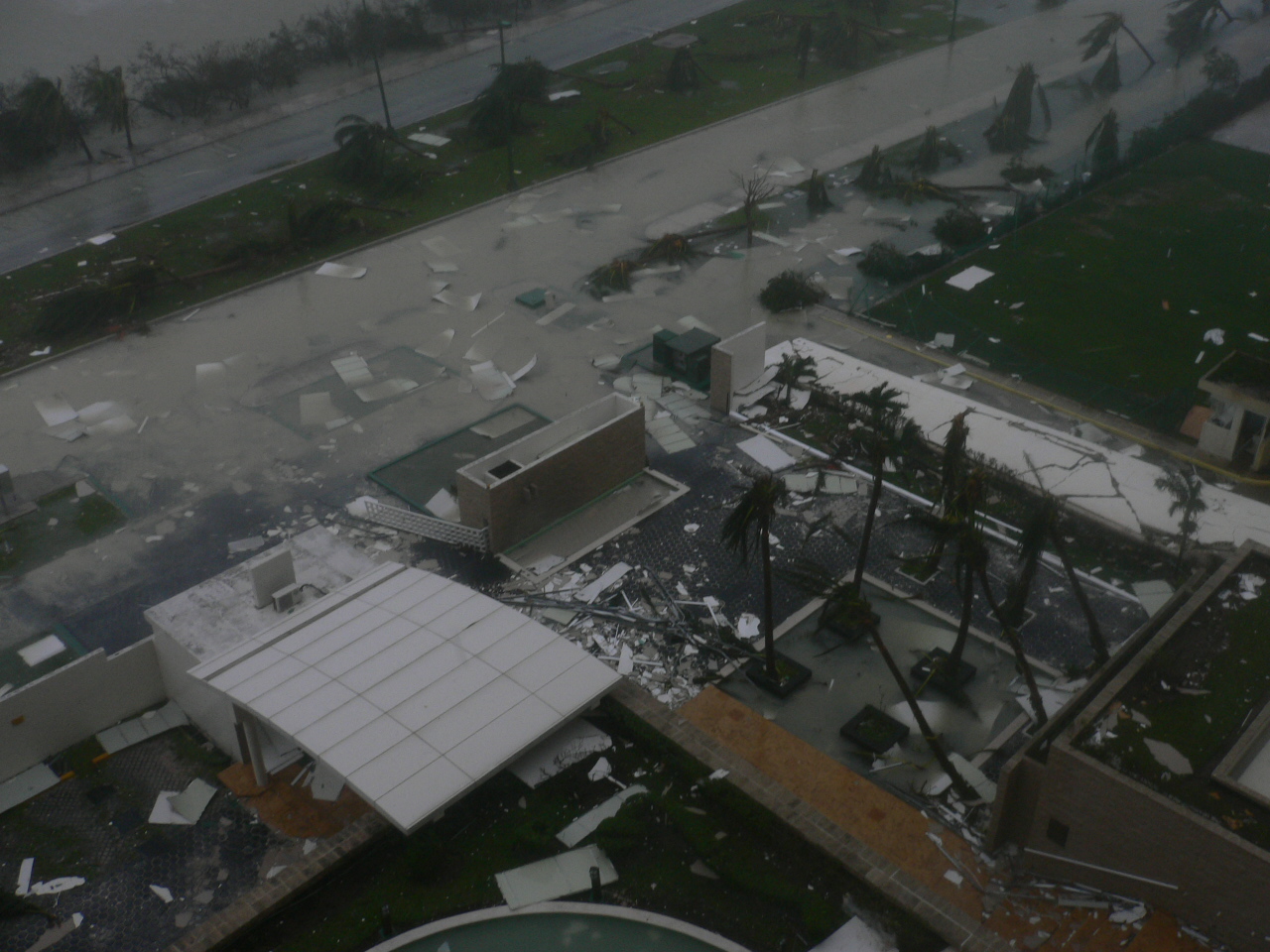
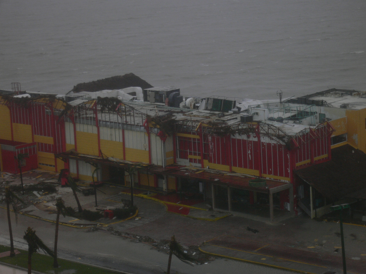
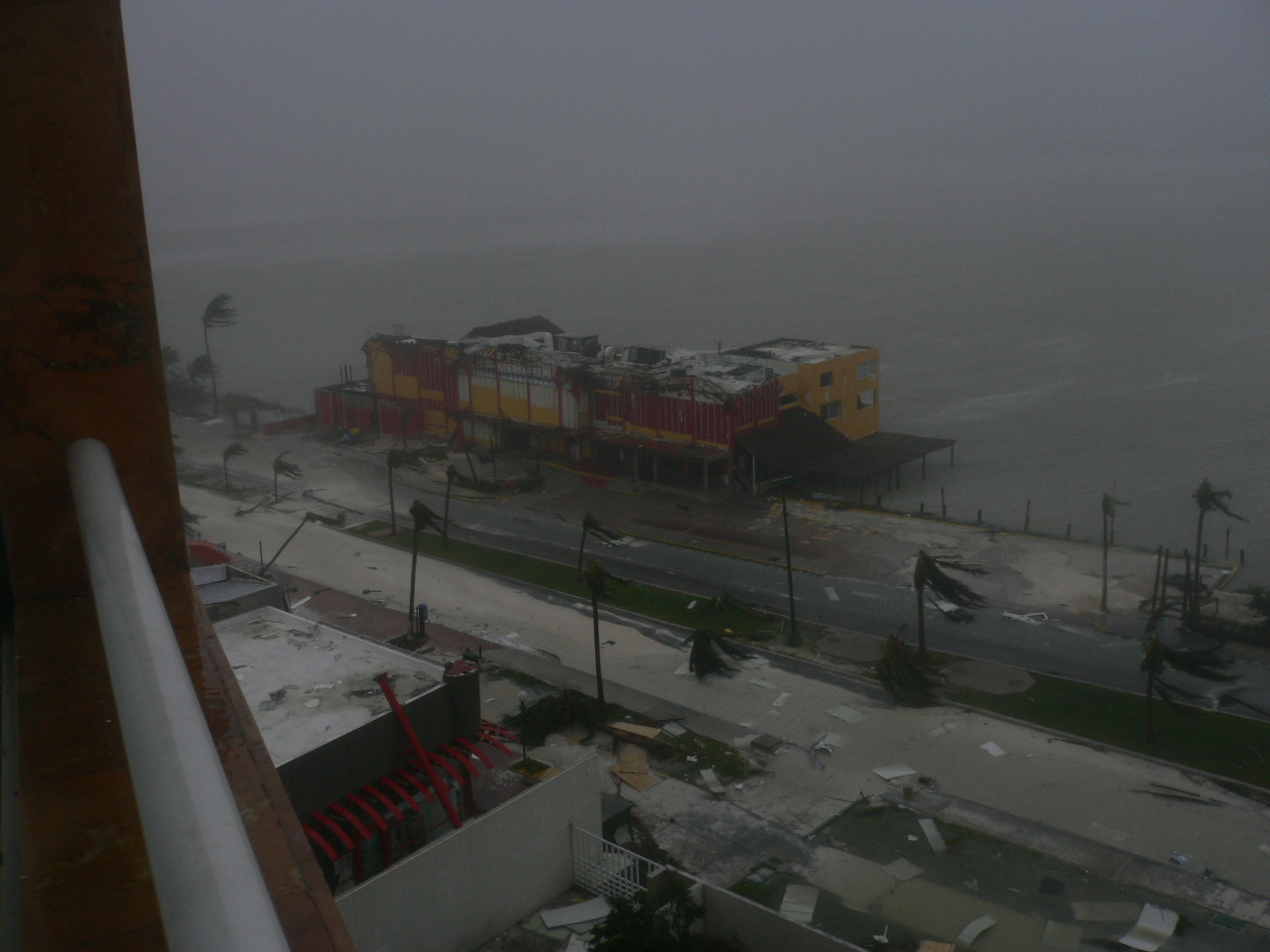
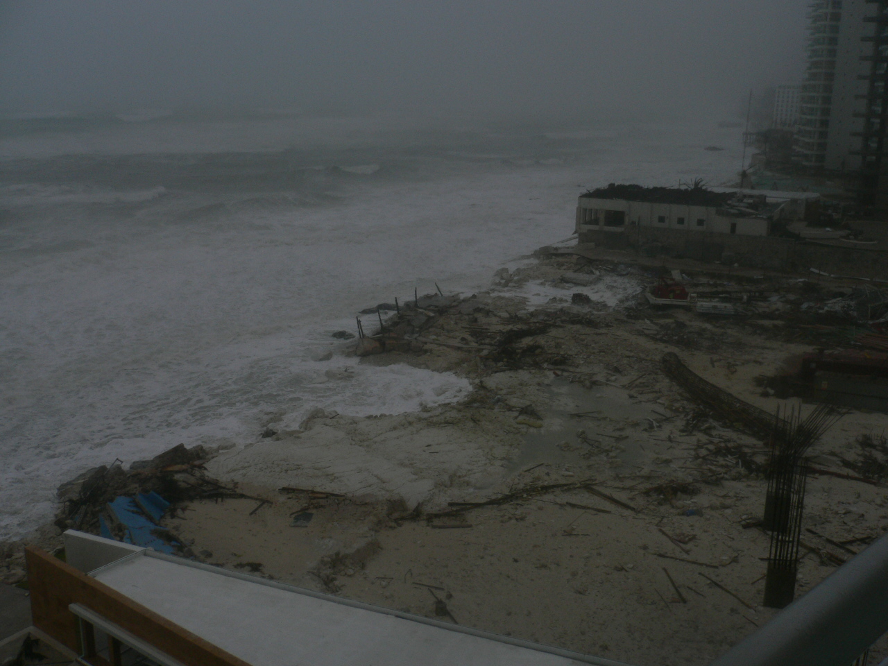
a couple of his good pics - I am dreading the pics of the beautiful hotel beachfront.
http://stormcarib.com/reports/2005/jpgBUR829MIxL.jpg
http://stormcarib.com/reports/2005/jpgWhJ7UKAT74.jpg
http://stormcarib.com/reports/2005/jpgmF7XqT6c0p.jpg
http://stormcarib.com/reports/2005/jpgeMMzaqEsxa.jpg
By Wednesay, Wilma should be long gone - but we don't know what kind of damage it would leave behind. That all depends on its final track and intensity.
MIA-FLL under hurricane watch tonight.
And remember, with a forward speed of 20-25 mph, it will feel like a category stronger to everyone south of the eye.
I haven't read the entire thread, so I don't know if you may or maynot have to hit the road. Just wanted you to know you are in my thoughts, and I wish the the best.
Granny Hugs
Some models are drifting north again, although they appear to converge from Charlotte to Collier Counties, although up here we will be on the nasty side of this unless it stays farther to the south, over the Keys for example, IMHO!!
Good point.
I heard Bill Clinton keeps a few blow frongs handy between intern sessions to keep from getting himself all beeber stuned. A side benefit is that he can keep his cigars properly humidified in their aquarium now that he doesn't have easy access to his human humidor anymore.
It's been said Clinton used to offer blow frong legs as state gifts to Jaques Chirac to keep on his good side.
And Al Gore has been accused at least once in Florida of getting blow frong chads pregnant.
But I'm not sure what a blow frong is so it's entirely possible that Blow Frong had somethig to do with Chinagate.
Where are you now?
Good for you. Last year, the only boats that survived the storms were the ones secured on their lifts.
We're in Illinois hugging grandbabies.
THAT'S WONDERFUL!
They are wasting no time. Brevard County has issued a mandatory evac of mobile and manufactured homes issued effecgtive 10AM Sunday, they do NOT think they will evac the barrier island but that could change. I believe the worry is about tornadoes in the outer bands as the fast moving storm approaches. Shelters open at 10AM Sunday. School already cancelled for Monday. No lines at gas stations, grocery store is typical Saturday, still water on the shelves. Gas still @ $2.76.
that sounds a lot better then what I had tonite, some kind of hamberger helper, thing.. I do so hate batching it!!
Am prepared.
Been watching the TV loop.
Seems like maybe the expectation has been adjusted a bit north.
With these things you never know and I don't think they really know for sure.
I remember last year Charlie was forecast to hit Tampa Bay, then it took an unexpected jog east into Pt. Charlotte. We watched the jog on TV and never felt anything only an hour north.
Lots of folks left Tampa area to flee to the south and got hammered there.
Watching and waiting.......:}
Here's another record for you - most number of names retired.
At this point, I figure it's six: Dennis, Emily, Katrina, Rita, Stan and Wilma. Who knows, Vince might get retired from novelty value. But the old record was four, shared by many active years.
Disclaimer: Opinions posted on Free Republic are those of the individual posters and do not necessarily represent the opinion of Free Republic or its management. All materials posted herein are protected by copyright law and the exemption for fair use of copyrighted works.