


| This thread has been locked, it will not receive new replies. |
|
Locked on 10/24/2005 2:24:18 AM PDT by Jim Robinson, reason:
New thread: http://www.freerepublic.com/focus/news/1508056/posts |
Posted on 10/22/2005 1:25:10 PM PDT by NautiNurse
Hurricane Wilma slowly drifts toward the Southeast Gulf of Mexico after relentlessly pounding Cozumel and Cancun for more than 24 hours. Early reports indicate extensive wind and flood damage to Mexico's resort-studded Mayan Riviera. Mexican officials said about 20,000 tourists were at shelters and hotels on the mainland south of Cancun and an estimated 10,000-12,000 were in Cancun itself. About 50 hotels were evacuated.
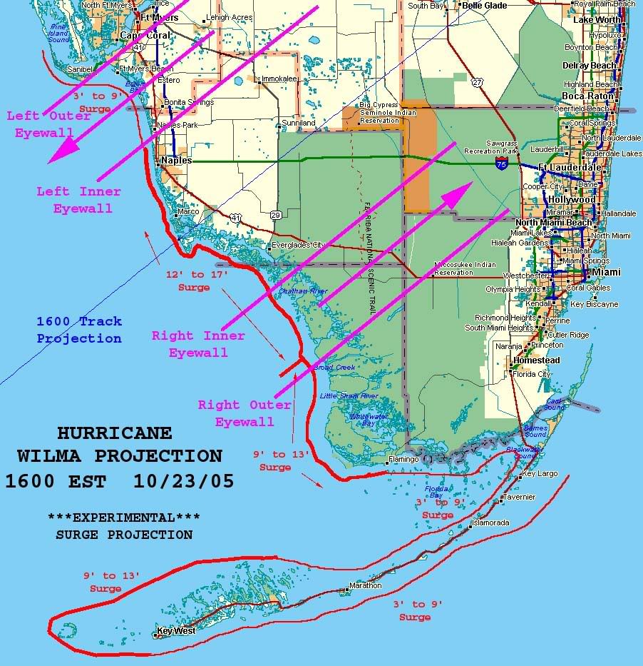
In preparation for Hurricane Wilma's anticipated Florida landfall, a Hurricane Watch and mandatory evacuation have been issued for the Florida Keys and Florida Bay. Mandatory evacuations for Marco Island and much of Naples are in effect, as well as high surf advisories and high risk of rip currents along Florida's panhandle and Big Bend coasts. Bus services are available for Monroe Co. and other counties for residents who do not have transportation. Additional storm watches for the Florida peninsula are expected later today.
The 2005 hurricane season altered the record books again today with the formation of Tropical Storm Alpha south of Hispanola. Preliminary forecasts indicate TS Alpha will not affect the U.S. mainland.
The following links are self-updating:
Public Advisory Currently published every 3 hours 0500, 0800, 1100 etc. ET
NHC Discussion Published every six hours 0500, 1100, 1700, 2300 ET
Three Day Forecast Track
Five Day Forecast Track
Wilma Forecast Track Archive
Forecast Models
Buoy Data SE Florida
Current Weather Warnings and Watches for Florida
Florida Department of Emergency Management
Images:
Storm Floater IR Loop
Visible Storm Floater Still (only visible during daylight hours)
Color Enhanced Atlantic Loop
Florida Radar/Sat Loop Caution: Broadband users only
Extra Large Miami Radar Broadband only
Extra Large Key West Radar Broadband only
Miami Long Range Radar Loop
Key West Long Range Radar Loop
Miami Experimental Radar Still Image
Key West Experimental Radar Still Image
Streaming Video:
WBBH-TV/WZVN-TV Ft. Myers (WMP): http://waterbc.wm.llnwd.net/waterbc_netvideo
WESH-TV/DT Orlando/Daytona Beach (RP): http://mfile.akamai.com/7883/live/reflector:24028.ram
WFTV-TV/DT Orlando (RP): http://mfile.akamai.com/7883/live/reflector:20361.ram
WKMG-TV/DT Orlando (RP): http://mfile.akamai.com/7883/live/reflector:23942.ram
WPBF-TV/DT West Palm Beach (RP): http://mfile.akamai.com/7883/live/reflector:24035.ram
WSVN-TV/DT Miami (WMP): http://216.242.118.140/windowsmedia/asx/wsvn_broadband.asx
WTVJ-TV/DT Miami: http://nbc6.feedroom.com/iframeset.jsp?ord=381015
WPLG-TV/DT Miami (RP): http://mfile.akamai.com/8660/live/reflector:23941.ram
WFOR-TV/DT Miami (WMP): http://wfor.dayport.com/viewer/content/special.php?Art_ID=612&Format_ID=2&BitRate_ID=8&Contract_ID=2&Obj_ID={obj_id}
WTSP-TV/DT St. Petersburg/Tampa (WMP): mms://wmbcast.gannett.speedera.net/wmbcast.gannett/wmbcast_gannett_sep252004_1915_64623
Hurricane City (Real Player) - http://hurricanecity.com/live.ram
ABCNews Now (Real Player) - http://reallive.stream.aol.com/ramgen/redundant/abc/now_hi.rm
Additional Resources:
Pet Friendly Florida Shelter Info
Central Florida Hurricane Center
Hurricane City
CrownWeather.com
| Category | Wind Speed | Barometric Pressure | Storm Surge | Damage Potential |
|---|---|---|---|---|
| Tropical Depression |
< 39 mph < 34 kts |
Minimal | ||
| Tropical Storm |
39 - 73 mph 34 - 63 kts |
Minimal | ||
| Hurricane 1 (Weak) |
74 - 95 mph 64 - 82 kts |
28.94" or more 980.02 mb or more |
4.0' - 5.0' 1.2 m - 1.5 m |
Minimal damage to vegetation |
| Hurricane 2 (Moderate) |
96 - 110 mph 83 - 95 kts |
28.50" - 28.93" 965.12 mb - 979.68 mb |
6.0' - 8.0' 1.8 m - 2.4 m |
Moderate damage to houses |
| Hurricane 3 (Strong) |
111 - 130 mph 96 - 112 kts |
27.91" - 28.49" 945.14 mb - 964.78 mb |
9.0' - 12.0' 2.7 m - 3.7 m |
Extensive damage to small buildings |
| Hurricane 4 (Very strong) |
131 - 155 mph 113 - 135 kts |
27.17" - 27.90" 920.08 mb - 944.80 mb |
13.0' - 18.0' 3.9 m - 5.5 m |
Extreme structural damage |
| Hurricane 5 (Devastating) |
Greater than 155 mph Greater than 135 kts |
Less than 27.17" Less than 920.08 mb |
Greater than 18.0' Greater than 5.5m |
Catastrophic building failures possible |
Previous Threads:
Hurricane Wilma Part II
Hurricane Wilma Live Thread
Tropical Storm Wilma
Tropical Depression #24
correction: 135kt
as if the 1kt matters, but...
Crack all the sections of the shell with a hammer or a nutcracker and let everyone pick the meat out themselves.
Bad hostess ... they could just do their own crab cracking. AND... what a mess... catching all those crabs to have to pinch off "a" claw. way too much work.
No wonder 3am advisory is late. It might very well be Cat 4 now
It's out now and they keep it Cat 3 (120mph)
Not good. Prayers for people on the coast.
Hurricane Wilma Intermediate Advisory Number 35b

Statement as of 3:00 am EDT on October 24, 2005

...Wilma slightly stronger...headed for the southwest coast of
Florida...


a Hurricane Warning remains in effect for all of the Florida
Keys... including the Dry Tortugas and Florida Bay...along the
Florida West Coast from Longboat Key southward... and along the
Florida East Coast from Titusville southward... including Lake
Okeechobee.


A Tropical Storm Warning remains in effect along the Florida West
Coast north of Longboat Key to Steinhatchee river...and along the
Florida East Coast north of Titusville to St. Augustine.


A tropical storm watch remains in effect along the northeast coast
of Florida from north of St. Augustine to Fernandina Beach.


A Hurricane Warning remains in effect for the Cuban provinces of
Ciudad de la Habana...la Habana...and Pinar del Rio.  A Tropical
Storm Warning is in effect for the Isle of Youth.  A Hurricane
Watch remains in effect for the province of Matanzas. These warnings
and watches will likely be later this morning.


A Hurricane Warning remains in effect for the northwestern
Bahamas...including the Abacos...Andros Island...Berry Islands...
Bimini...Eleuthera...Grand Bahama Island...and New Providence.


For storm information specific to your area...including possible
inland watches and warnings...please monitor products issued
by your local weather office.

The previous position estimate was a little too far to the east.
At 3 am EDT...0700z...the large eye of Hurricane Wilma was
located near latitude 25.1 north... longitude 82.8 west or about
75 miles west-northwest of Key West Florida and about 95 miles
southwest of Naples Florida.


Wilma is moving toward the northeast near 20 mph... and a continued
increase in forward speed is expected during the next 24 hours.  On
this track the center will make landfall along the southwestern
coast of the Florida Peninsula later this morning.  However...this
is a large hurricane and wind gusts to hurricane force have already
spread over portions of the lower Florida Keys.  The eastern
portion of the eyewall... accompanied by the strongest winds...
will reach the southwestern coast of Florida about 2 hours before
the center of the large eye makes landfall.


Maximum sustained winds are near 120 mph...with higher gusts.  Wilma
is a category three hurricane on the Saffir-Simpson scale.  No
significant change in strength is expected until landfall.  Some
weakening is likely as Wilma crosses the southern Florida Peninsula
today.

Hurricane force winds extend outward up to  85 miles from the
center...and tropical storm force winds extend outward up
to 230 miles.  A wind gust to 76 mph was recently reported at Key
West.

The estimated minimum central pressure is 954 mb...28.17 inches.


Storm surge flooding of 9 to 17 ft above normal tide levels is
possible along the southwest Florida coast near and to the
south of where the center of Wilma makes landfall.  Storm surge
flooding of 5 to 8 ft above normal is possible in the Florida Keys
and Florida Bay... as well as in Lake Okeechobee.  Storm surge
flooding of 2 to 4 feet is possible along the extreme southeastern
coast of Florida.


Wilma may produce additional rainfall accumulations of 5 to 10
inches through today across portions of western Cuba.  Rainfall
across southern Florida and portions of central Florida...
including the Florida Keys is expected to be 4 to 8 inches... with
isolated maximum amounts of 12 inches possible.  Rainfall totals of
2 to 4 inches will be possible over portions of the northwest
Bahamas.


Large swells generated by Wilma will continue to affect portions of
the northeastern Gulf Coast from the Florida Keys northward today.

Some tornadoes are possible over portions of the central and
southern Florida Peninsula and the Florida Keys this morning.

Repeating the 3 am EDT position...25.1 N... 82.8 W.  Movement
toward...northeast near 20 mph.  Maximum sustained winds...120 mph.
Minimum central pressure... 954 mb.


The next advisory will be issued by the National Hurricane Center at
5 am EDT.


Forecaster Pasch
Does she know she's keeping US up with worry? :-)
Yeah, really!!!!
I have a friend in Miami who just refuses to take this seriously. He's home visiting his family between assignments on a Hawaiian cruise ship. "You worry too much," he admonishes me.
I can't help it, though. My daughter's paternal relatives are scattered all over Florida. My little girl gets really upset because her Grandma chooses not to evacuate, and now both her uncles are down there, too. I've got my own relatives and some snowbird friends on my mind as well.
Maybe my friend in Miami is shrugging it off because he's not a homeowner there, and he's just staying at his brother's house until it's time for him to return to work in Honolulu next weekend. He won't be around to deal with the mess Wilma's going to leave behind.
Still, his casual indifference drives me up the wall!
I doubt I'll need to, thankfully. I'm about a mile and a half from Biscayne Bay, but they're not expecting surge there greater than 2 to 4 feet. The immediate area where my house is located is the highest ground in Cutler Ridge. When Katrina came through, she dumped 18 inches of rain here. All of Cutler Ridge had 2 feet of floodwater for several days, except for two or three blocks around my house.
I think Orlando Salinas should just go inside now.
Would someone please bonk Orlando Salinas in the head with a polo mallet and drag him inside? He hasn't the sense to come in from the storm already. He's gonna get himself killed.
He doesn't even have shoes.
I see we had pretty much the same thought.
"What did you say, Pops? I'm kinda deaf."
"Rocco!"
"He said Rocco. Hehehhe."
421
URNT12 KNHC 240711
VORTEX DATA MESSAGE
A. 24/06:59:30Z
B. 25 deg 08 min N
082 deg 50 min W
C. 700 mb 2695 m
D. NA kt
E. NA deg nm
F. 222 deg 135 kt
G. 124 deg 046 nm
H. 952 mb
I. 8 C/ 3056 m
J. 17 C/ 3047 m
K. 12 C/ NA
L. CLOSED WALL
M. C65
N. 12345/ 7
O. 0.02 / 3 nm
P. AF305 2424A WILMA OB 39
MAX FL WIND 135 KT SE QUAD 06:45:40 Z
SOME LIGHTNING VISIBLE IN NW EYEWALL
$#@%&!!!
Where's Hunble now? I'd like him to tell us again how this is a rather minor, weakening storm!
Are the recon numbers from their flight level? If so, you need to take it down some (80%???) to get what the numbers are near the ground if i recall.
I smell a Pulitzer Orlando!
Disclaimer: Opinions posted on Free Republic are those of the individual posters and do not necessarily represent the opinion of Free Republic or its management. All materials posted herein are protected by copyright law and the exemption for fair use of copyrighted works.