The following sums up the whole story nicely:
Gretna (pop. 17,500) is a feisty blue-collar city, two-thirds white, that prides itself on how quickly its police respond to 911 calls; it warily eyes its neighbor, a two-thirds black city (pop. about 500,000) that is also a perennial contender for the murder capital of the U.S.
Itself deprived of power, water and food for days after Katrina struck Aug. 29, Gretna suddenly became the destination for thousands of people fleeing New Orleans. The smaller town bused more than 5,000 of the newcomers to an impromptu food distribution center miles away. As New Orleans residents continued to spill into Gretna, tensions rose.
After someone set the local mall on fire Aug. 31, Gretna Police Chief Arthur S. Lawson Jr. proposed the blockade.
If I was a Gretna homeowner, I would be proud of this Police Chief, too.
If I was a Gretna homeowner, I would be proud of this Police Chief, too. Yep. Wouldn't want a bunch of stinky old refugees, barefoot and reeking from the mud, carrying their children on their backs, to mess up the place.
The flooded area is marked, as are the two downtown collection points, and the Gretna roadblock. The closest point of aid for evacuees was the major collection point that had been established at the junction of the I-10 and the Causeway Road, to the west of New Orleans in Metairie (big green dot), which in turn was supplied from the airport. To help people, they had to get to this point (assuming officials continued to deny relief officials entry into the city proper, but that's another issue). 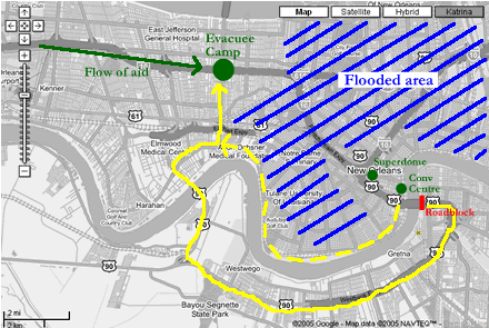
The yellow solid line is the route, nearly 20 miles by my rough estimate, crossing the Mississippi twice, that was effectively blocked by Gretna police. The dashed route, along the high ground on the north side of the Mississippi, is the route that it appears a significant number of individuals (including the two EMS techs) ultimately ended up taking to get out after it was clear the Gretna bridge was blocked.
All the Gretna policewere blocking, it turns out, was a massive detour...
http://www.snappingturtle.net/flit/archives/2005_09_10.html