Thanks!
Wow. I would not want to have been on that little piece of land where US 90 crosses, between those two lakes. You know that's got to have been flooded, and badly.
}:-)4
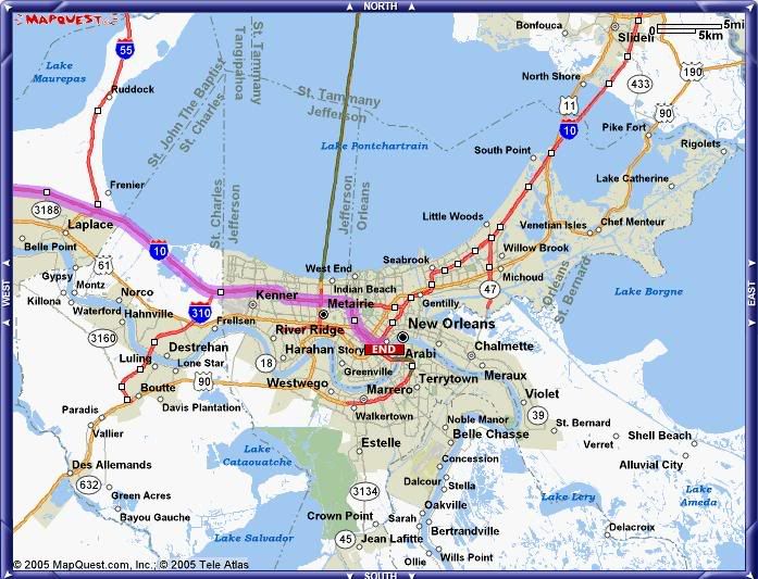
Good map, I'm going to repost it and provide some references for those not familiar with the area.
For those who look closely, you'll see a faint blue line that is the Industrial Canal running north/south on the east side of New Orleans. Starts under the name "Seabrook", runs just west of the name "Gentilly" and joins the Mississippi River just south of the 'N' in "New Orleans". Running east/west just north of "Gentilly" from Lake Borgne in the east to the Industrial Canal is the Intercoastal Waterway. These 2 canals divide the city into 3 sections, each of which have their own levee system. So basically the NO area north of the Mississippi River is 3 bowls.
To the west of the Industrial Canal is the biggest, containing downtown New Orleans and further west Metarie and Kenner. So far it appears that none of the levees were overtopped, and the flooding is mainly rainwater confined to the lowest spots.
The smallest bowl is to the southeast, containing Arabi and Chalmette. The Miss. River rose high enough to overtop the levee, and so far it appears that this bowl filled to as much as 12' deep. This is the area where the water to the rooftop shots are from, and apparently where several casualties are. This area may have gotten the catastrophic storm surge flooding that was feared for the rest of the city. It was closer to the eye and full surge force than downtown.
Haven't heard much from the northeast bowl, but there were earlier some reports that an area of the levee along Lake Pontchartrain was (at least briefly) overtopped.
Other points of reference: Jefferson Parish is the area on the south side of the Miss. River from NO. Slidell is across the lake in the northest corner of the map. The hurricane made landfall several miles east of Slidell, just to the east of the map's edge, which is roughly the MS/LA border. Covington is just north of the map, where the causeway bridge reaches the north shore of Lake Pontchartrain(the green line.)