Posted on 07/13/2005 7:11:21 PM PDT by NautiNurse
772 URNT12 KNHC 161222 VORTEX DATA MESSAGE A. 16/11:52:30Z B. 15 deg 51 min N 076 deg 28 min W C. 700 mb 2610 m D. 45 kt E. 38 deg 102 nm F. 103 deg 148 kt G. 14 deg 010 nm H. 946 mb I. 7 C/ 3068 m J. 14 C/ 3046 m K. 14 C/ NA L. CLOSED M. C13 N. 12345/ 7 O. 0.02 / 1 nm P. AF302 0705A EMILY OB 03 MAX FL WIND 148 KT NE QUAD 11:49:50 Z MAX FL TEMP 15 C 210 / 6 NM FROM FL CNTR EXCELLENT RADAR REPRESENTATION |
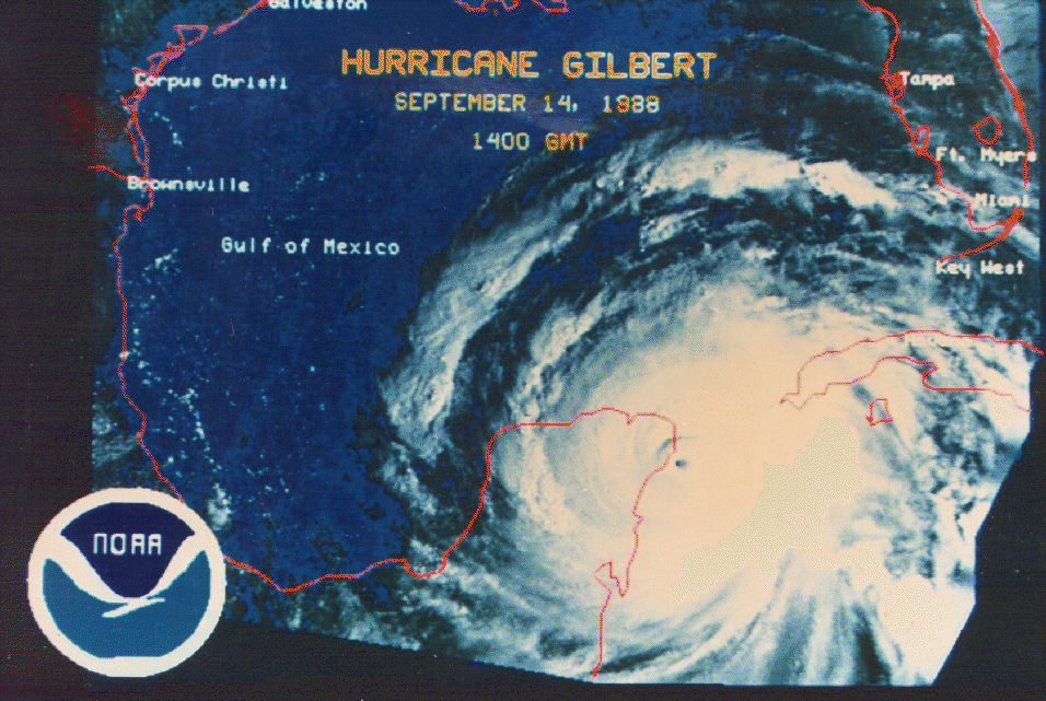
Vortex data indicate closer to 153mph. Holy cow.
153? Gilbert size? (I think it was Gilbert)
many thanks..
Gilbert's pressure was much lower--888mb. This one is 944mb now.
Thanks, I coulda 'googled', but knew it would be quicker here...Gilbert was 155+, wasn't it...?
WOW !!!
Have the Mexican Gov't issued any Storm Surge warnings for the outer eastern islands yet ?
Emily is @ 700 miles from Cozumel(Mexico), and his Hurricane might be a Cat-5 within hours.
Isaac's Storm is a fantastic book. I've read it twice. Once when it first came out in 2000, and then I recently re-read it. You just cannot even fathom the horror those people experienced during that storm. Chilling.
How can I obtain that inform ?
please...thanks
They said the experience was very scary.
I'll bet it was scary.
Gotta admit, that picture is awesome...
Thank you, NN, that was an incredible story!
looks to be wobbling a bit more north. I don't think upper Texas coast is out of the woods yet.
468 URNT12 KNHC 161345 VORTEX DATA MESSAGE A. 16/13:28:10Z B. 15 deg 59 min N 076 deg 52 min W C. 700 mb 2591 m D. 50 kt E. 135 deg 036 nm F. 225 deg 114 kt G. 133 deg 005 nm H. 943 mb I. 10 C/ 2855 m J. 17 C/ 3051 m K. 14 C/ NA L. CLOSED M. C13 N. 12345/ 7 O. 0.02 / 1 nm P. AF302 0705A EMILY OB 09 MAX FL WIND 148 KT NE QUAD 11:49:50 Z |
Interesting storm, isn't she?
...Extremely dangerous category four Emily moving
west-northwestward...rainbands spreading over Jamaica...
a Hurricane Warning remains in effect for Jamaica and for all of the
Cayman Islands.
A Hurricane Warning means that hurricane conditions are expected
within the warning area within the next 24 hours.  Preparations to
protect life and property should be rushed to completion.
At 11 am EDT...1500 UTC...the government of Mexico has issued a
Hurricane Watch for the eastern coast of the Yucatan Peninsula from
Chetumal to Cabo Catoche including the islas mujeres.
A Hurricane Watch means that hurricane conditions are possible
within the warning area within the next 36 hours.
A Tropical Storm Warning is in effect for the entire southwestern
peninsula of Haiti from the Dominican Republic/Haiti border to
Port-au-Prince.  This warning will likely be discontinued later
today.
At 11 am EDT...the government of Belize has issued a tropical storm
watch for the coast of Belize from Belize City northward to the
Belize-Mexico border.
Interests elsewhere in the central and western Caribbean...and the
southern Gulf of Mexico...should monitor the progress of Emily.
For storm information specific to your area...including possible
inland watches and warnings...please monitor products issued
by your local weather office.
At 11 am EDT...1500z...the center of Hurricane Emily was located
near latitude 16.2 north...longitude  77.3 west or about  130
miles... 205 km...south-southwest of Kingston Jamaica and about
335 miles... 540 km...southeast of Grand Cayman.
Emily is moving toward the west-northwest near 18 mph...30 km/hr...
and this general motion is expected to continue for the next 24
hours.  This motion should bring the center of Emily south of
Jamaica today and near Grand Cayman island tonight.
Reports from an Air Force Reserve hurricane hunter aircraft indicate
that maximum sustained winds are near 145 mph...230 km/hr...with
gusts.  This makes Emily a category four hurricane on the
Saffir-Simpson scale.  Some fluctuations in strength are expected
during the next 24 hours.
Hurricane force winds extend outward up to  70 miles...110 km...
from the center...and tropical storm force winds extend outward up
to 150 miles...240 km.  For Jamaica...hurricane force winds may
occur in gusts in rainbands along the coasts...with possible
sustained hurricane force winds at higher elevations...especially
above 3000 feet.
The latest minimum central pressure reported by the hurricane hunter
is  943 mb...27.85 inches.
Emily may produce rainfall accumulations of 5 to 8 inches over
Jamaica with maximum amounts of 15 inches over mountainous terrain.
Rainfall totals of 5 to 8 inches is possible over the Cayman
Islands...with some 1 to 3 inch amounts possible over southeastern
Cuba.  These rains could produce life-threatening flash floods and
mud slides.  Rains will be diminishing over the western portion of
Hispaniola today.
Repeating the 11 am EDT position...16.2 N... 77.3 W.  Movement
toward...west-northwest near 18 mph.  Maximum sustained
winds...145 mph.  Minimum central pressure... 943 mb.
An intermediate advisory will be issued by the National
Hurricane Center at 2 PM EDT followed by the next
complete advisory at 5 PM EDT.
Forecaster Beven
Disclaimer: Opinions posted on Free Republic are those of the individual posters and do not necessarily represent the opinion of Free Republic or its management. All materials posted herein are protected by copyright law and the exemption for fair use of copyrighted works.