Skip to comments.
Submarine Crash Shows Navy Had Gaps in Mapping System
NY Times ^
| January 15, 2005
| CHRISTOPHER DREW
Posted on 01/14/2005 8:30:19 PM PST by neverdem
click here to read article
Navigation: use the links below to view more comments.
first previous 1-20, 21-40, 41-60, 61-80 ... 221-235 next last
To: drt1
41
posted on
01/14/2005 9:48:47 PM PST
by
MEG33
(GOD BLESS OUR ARMED FORCES)
To: endthematrix
"Remember the bombing of the Chinese embassy in Belgrade..."
Very good point, ETM! It's crazy isn't it...we can drop a bomb down a bunker in Tora Bora or some other obscure mountain pass cave. We probably do satellite snipe hunts on *endangered* critters and spend fortunes doing so but somehow basic defense needs (along with a submariner) were skuttled for lack of resources. We've even landed on one of Saturn's moons for heavens sake!!! Some should be hung out to dry "bigtime" on this. This is beyond the pale.
To: El Gran Salseron
You gave a good answer about the disposition of Bucher's case.
In '69, I was at Coronado where the inquiry was going on. Saw a lot of beat up and sad sailors from Pueblo. You got it right about the capture but electronics wasn't the big deal. Codeword material was compromised. All codewords were changed overnight once Pueblo was seized. That's memorable.
Good to meet you, Sal.
43
posted on
01/14/2005 9:59:10 PM PST
by
BIGLOOK
(I once opposed keelhauling but have recently come to my senses.)
To: Ernest_at_the_Beach
Thanks for the ping!
Like we postulated: seamount and inadequate mapping. I'd surely hate to have to navigate that area submerged with any of the charts I've seen.
Don't have them handy right now, but I bet that National Geographic has better relief maps of the seafloor than these... :-(
44
posted on
01/14/2005 10:02:03 PM PST
by
TXnMA
(Attention, ACLU: There is no constitutionally protected right to NOT be offended -- Shove It!)
To: neverdem
Easy on me.... The one just above #4 I had fixed, it works..... That will get you started......
45
posted on
01/14/2005 10:22:28 PM PST
by
Ernest_at_the_Beach
(A Proud member of Free Republic ~~The New Face of the Fourth Estate since 1996.)
To: Domestic Church
>>>
never had the resources to use the satellite data systematically." <<< Someone please explain how "satellite data" can do anything but tell you where you are on the face of the earth - and to locate on that same face "known" obstructions.
Sounds to me like someone is expecting GPS to peer under the ocean to see sea-mounts. Not happening.
To: TXnMA; Boot Hill; snopercod; RadioAstronomer; drt1; Doctor Stochastic; steplock; HiTech RedNeck; ...
Like they say, we know more about the surface of Mars than we do the Sea Floor on Planet Earth.....
We need a heavy technology discussion on what radar can do about peering through 1000 feet of water to map the undersea.....
I don't think it can, radar depends on reflection...
47
posted on
01/14/2005 10:31:44 PM PST
by
Ernest_at_the_Beach
(A Proud member of Free Republic ~~The New Face of the Fourth Estate since 1996.)
To: steplock
MAybe "used to have most accurate" maps.
Al Gore - in re-inventing Govt took an axe to the NOAA Corps (#7 of the 7 uniformed services) and tried to disolve the NOAA Dept altogether. Result, NOAA is forced to contract out ocean mapping and the result 'vary'.
Rainer - the ship that made the mountain famous and the beer that made it possible.
48
posted on
01/14/2005 10:33:47 PM PST
by
ASOC
(Land of the Free, owing to the Brave)
To: HardStarboard
Right!
I think the mid atlantic rift waS MAPPED at great effort....using special equipment (suspended at great depths ) and some kind of sonar...
49
posted on
01/14/2005 10:33:55 PM PST
by
Ernest_at_the_Beach
(A Proud member of Free Republic ~~The New Face of the Fourth Estate since 1996.)
To: Ernest_at_the_Beach
From here:
Viewing the Morphology of the Mid-Atlantic Ridge From a New Perspective
We have:
The nature of the volcanic and tectonic response of mid-ocean ridges to magmatic and rifting processes is a key component in understanding how new ocean crust is created. New high-resolution side-scan sonar images of the axis of the slow-spreading Mid-Atlantic Ridge (MAR) show volcanic constructs and faults and fissures that are similar in size and shape to those observed at well-studied subaerial rift zones such as Hawaii and Iceland. The new information provided by these high resolution side-scan sonar images, combined with swath bathymetric coverage, is now allowing us to apply the terrestrial analogs to the MAR to understand dike emplacement, shallow transport of magma, eruption mechanisms, tectonic strain, and crustal evolution.
These images are changing our ideas about the formation and evolution of slow-spreading crust. They indicate that magmatic pro- cesses at the MAR may be more comparable to those at subaerial rift zones than previously thought. Furthermore, these data are enabling us to design future detailed geophysical and geochemical studies at the MAR at the same scale as used at subaerial rifts.
50
posted on
01/14/2005 10:40:09 PM PST
by
Ernest_at_the_Beach
(A Proud member of Free Republic ~~The New Face of the Fourth Estate since 1996.)
To: All
The TOBI deep-towed side-scan vehicle was developed at the Institute of Oceanographic Sciences (now part of the Southampton Oceanography Centre) in the United Kingdom with funds from the Natural Environment Research Council.The Navy needs to get some of this technology....
51
posted on
01/14/2005 11:04:06 PM PST
by
Ernest_at_the_Beach
(A Proud member of Free Republic ~~The New Face of the Fourth Estate since 1996.)
To: Ernest_at_the_Beach
Ernest, is there any chance this a new formation from the tsunami?
52
posted on
01/14/2005 11:05:13 PM PST
by
Howlin
(I need my Denny Crane!)
To: wildbill
Remember the skipper of the Indiana was steaming through the Pacific when torpedoed by a Japanese sub.
USS Indianapolis (CA-35).
To: wildbill
54
posted on
01/14/2005 11:05:42 PM PST
by
Smokin' Joe
(Live from an oil rig in eastern Montana...)
To: judicial meanz; submarinerswife; PogySailor; chasio649; gobucks; Bottom_Gun; Dog Gone; HipShot; ...
Steely-Eyed Killers of the Deep
55
posted on
01/14/2005 11:12:12 PM PST
by
Ready4Freddy
(Veni Vidi Velcro)
To: neverdem; Ernest_at_the_Beach; BIGLOOK; SubMareener; U S Army EOD; WildTurkey; SilentServiceCPO
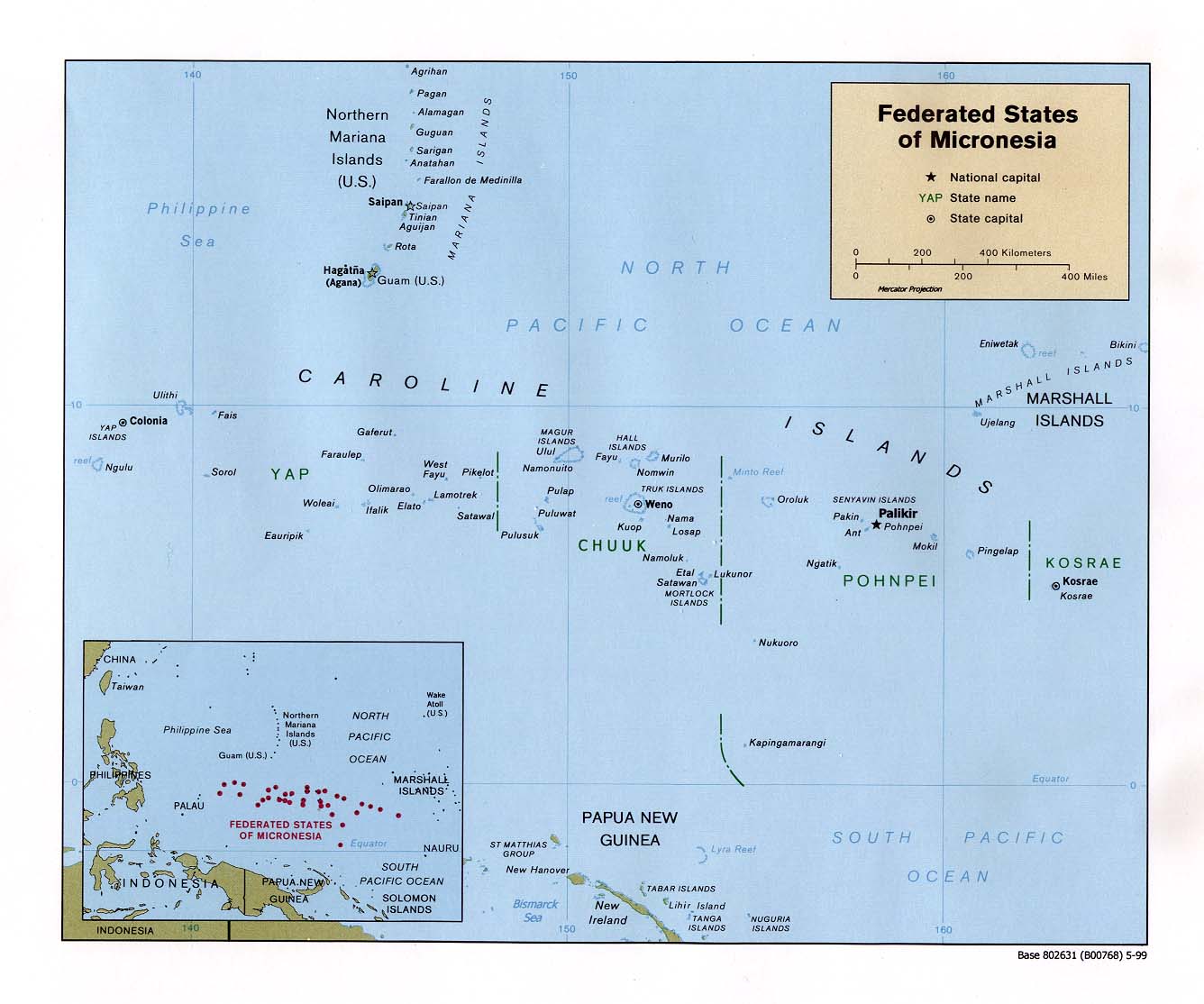
Compare these two maps and note that we finally have approximate coordinates for the crash site, 07º44'N, 147º22'E, which places the scene (via great circle route calculation) at 700km (435mi.) SSE (155º) from SSN 711's (USS San Francisco) home port of Apra Harbor, Guam. Note the mileage is not the 360-370 miles that this, and other, MSM article have been quoting, but rather 75 miles farther SSE.
Note that the following islands in the Caroline Island chain can be seen on both maps and define the area around the crash site: Lamotrek, Pikelot, Satawal, West Fayu. To effectitvely view these maps, push F-11 on your keyboard.

That is all...
--Boot Hill
56
posted on
01/14/2005 11:14:32 PM PST
by
Boot Hill
(How do you verbalize a noun?)
To: Howlin
Well definitely not from the Tsunami....I suppose it might have a remote possibility of being tied in with the elemental forces that caused the tsunami....
Although the article implied that there was prior indication of something there:
But since the accident, Mr. Andreasen said, his office has examined commercially available images taken by a Landsat satellite in 1999, and at least one image indicates that an undersea mountain could rise to within 100 feet of the surface there. Analysts say variations in water color can sometimes indicate a land mass below.
57
posted on
01/14/2005 11:15:03 PM PST
by
Ernest_at_the_Beach
(A Proud member of Free Republic ~~The New Face of the Fourth Estate since 1996.)
To: Ernest_at_the_Beach
We need a heavy technology discussion on what radar can do about peering through 1000 feet of water to map the undersea..... I don't think it can, radar depends on reflection...
Mapping the Seafloor from Outer Space
"The time it takes the energy to return to the satellite is used to measure the distance to the sea surface very precisely (within accuracies of less than an inch!)"
According to this link, and depending on the effects of water temperature and surface currents, a seamount of 1000 feet elevation above the surrounding ocean floor would be reflected in an increase of one foot of the ocean's surface. Don't ask me how they account for the motion in ocean's surface motion unless they take the mean time of the reflected beam after repeated passes of the satellite.
58
posted on
01/14/2005 11:17:00 PM PST
by
neverdem
(May you be in heaven a half hour before the devil knows that you're dead.)
To: El Gran Salseron
That's my point. They are blind, and we need better charts. What I don't hear being brought up are the
Low Frequency Active Sonar arrays and whales... remember that the US Navy has been harassed by activists trying to block them from using platforms with high-powered (200+ deciBel) sonar to improve the charts.
Seems to me that while this accident might not have been directly prevented by an unharassed program, it certainly points to a need for the LFAS program.
(BTW, link provided for reader convenience...not sure about the info on it--it's Federation of American Scientists.)
59
posted on
01/14/2005 11:17:25 PM PST
by
Gondring
(They can have my Bill of Rights when they pry it from my cold, dead hands!)
To: Boot Hill
I think the skipper was driving too fast.
60
posted on
01/14/2005 11:19:30 PM PST
by
Ernest_at_the_Beach
(A Proud member of Free Republic ~~The New Face of the Fourth Estate since 1996.)
Navigation: use the links below to view more comments.
first previous 1-20, 21-40, 41-60, 61-80 ... 221-235 next last
Disclaimer:
Opinions posted on Free Republic are those of the individual
posters and do not necessarily represent the opinion of Free Republic or its
management. All materials posted herein are protected by copyright law and the
exemption for fair use of copyrighted works.
FreeRepublic.com is powered by software copyright 2000-2008 John Robinson