
Posted on 12/28/2004 2:10:18 PM PST by M. Espinola
How a tsunami develops
A tsunami is made up of a series of travelling ocean waves of extremely long wavelength. They are triggered by large disturbances such as earthquakes, undersea volcanic eruptions or deep sea landslides.
The figure below shows the amplitude, trough and crest of a tsunami wave in relation to the sea floor and still water level. Note how the wave shape changes and the height increases as it approaches the coastline.

Effects of tsunami Tsunami are a threat to people and property in coastal and low-lying estuarine areas. The waves travel quickly, rapidly flooding and damaging coastal communities, picking up debris as they go. A fast moving wave over 10 metres high can quickly destroy homes and communities. Tsunami also create seiching in harbours and confined estuaries.
Tsunami waves can travel inland along river beds as continuous single standing waves. This puts smaller inland communities at risk and contaminates rivers with saltwater.
A tsunami can threaten 'lifeline' services such as water, power, telecommunication and transportation networks. Find out more about managing Lifelines to deal with unexpected emergencies or natural hazards.

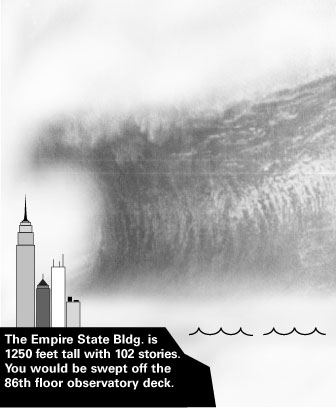
An immense wave could one day wreak havoc on the eastern seaboard of the US and elsewhere around the Atlantic.
"It's entirely possible you'd see 50-metre waves coming ashore in Florida, New York, Boston, all the way up to Greenland, and in some cases reaching up to 10 km inland" Dr Simon Day
Scientists say a volcanic eruption on the Canary Islands, off West Africa, could trigger a vast undersea landslide.
This would set off a tsunami wave capable of inundating coastal regions thousands of kilometres away.
The warning comes from Dr Steven Ward, of the University of California, US, and Dr Simon Day, of the Benfield Greig Hazard Research Centre at University College London, UK.
Writing in Geophysical Research Letters, they refine an earlier estimate of the likely consequences of the collapse of the western flank of the Cumbre Vieja volcano on the island of La Palma in the Canaries.

They believe a build-up of groundwater could destabilise a block of rock up to 500 cubic km in size, which could break off in a future eruption, rushing into the sea at up to 350 km an hour (220 mph).
The energy released by the collapse would equal the entire US electricity consumption for six months.
The dome of water it caused would be 900 metres (2,950 feet) high, and the resulting tsunami, higher than any in recorded history, would travel outwards, reaching speeds of 800 km an hour (500 mph).
Waves 100 m (330 ft) from crest to trough would strike the African coast, while north-eastwards they would affect Spain, Portugal and France, and could still be approaching 12 m (40 ft) when they hit the UK.
That is almost three times the maximum recorded after the Lisbon earthquake of 1755.
Dr Day said the waves striking the UK coast would not penetrate more than two or three kilometres inland.
But he told BBC News Online: "Weird things happen when tsunamis enter harbours or estuaries.
"If those resonate at a certain frequency, that may substantially increase the damage."
Many centuries
Across the Atlantic the damage would be far worse, with wave heights of more than 40 m (130 ft) expected in northern Brazil.
Dr Day said: "It's entirely possible you'd see 50-m waves coming ashore in Florida, New York, Boston, all the way up to Greenland, and in some cases reaching up to 10 km inland.
"And that would be about nine hours or more after the initial collapse."

The ensuing economic losses would probably be in trillions of dollars, even if there were enough warning to evacuate threatened areas and avoid massive loss of human life.
If the speed of the landslide proved to be 150 metres per second (490 feet per second), not the 100 m/s (330 ft/s) assumed, that could double the height of the waves reaching the US.
But Dr Day had some reassurance on the probable timescale of the catastrophe.
He said a collapse was unlikely this century, and perhaps for many centuries.
It could take several eruptions to destabilise the volcano enough to dislodge the western flank, and collapse would occur only after days or weeks of seismic activity.
He told BBC News Online: "We think you have to see some evidence of subterranean movement before there's a risk of collapse.
"The fact that we aren't seeing any movement gives us a lot of confidence Cumbre Vieja won't collapse spontaneously.
"But we've found that eruptions do tend to come in clusters. And there've been two in the recent past."
The disturbance moves outwards. The central point just oscillates until it's damped out by friction. As it oscillates the disturbance propagates outwards.
"will both activities generate a tsunami..and the same type
Yes. If the wave moves a bunch of wavelengths, they both look the same. Close to the initital disturbance, it depends on how the oscillation starts.
Does this mean beach front real estate prices will decrease?

LVM
Can You Make that Bigger Please ?
LOL!!!!!!!!!!!!!
The scenairo they are talking about has nothing to do with plate movement. The cause is half of a mountain (volcano)sliding into the ocean.
Drop a large rock into some deep water - same effect.
The bad news is - there is another one waiting to go off in the Pacific. The Big Island of Hawaii. Do some research on the "Great Rift" on that island. Huge hunk of the island sliding into the ocean.
The really bad news is that it is aimed at California. They were doing a geologic survey off the coast a few years back and found evidence that it has "fallen off" before. The slide went miles out. The calculations for the height of the wave created by that was mind boggling - 800 - 1000 ft., if I remember right.
So, when you play tourist - keep your jumping up and down to a minimum, ok?
LVM
I'm sorry, but I can't quite make out the pic you posted. Could you please enlarge it? TIA!
Heavy seas
http://www.tv-antenna.com/heavy-seas/
bttt
If recent history is any example, look at Florida being smashed with one Hurricane after the another during the 2004 season with even loss of life, yet, people will still pay incredible prices to live on either coastline.
That map was on a LARGE size.
Yes, I think it was called the USS Bouron Liver.
Disclaimer: Opinions posted on Free Republic are those of the individual posters and do not necessarily represent the opinion of Free Republic or its management. All materials posted herein are protected by copyright law and the exemption for fair use of copyrighted works.