Skip to comments.
Satellite Image of Bam After the Earthquake
Intellegence Resource Program ^
| 12/27/03
| NA
Posted on 12/30/2003 11:53:43 PM PST by prisoner6
Satellite Image of Bam, Iran Earthquake
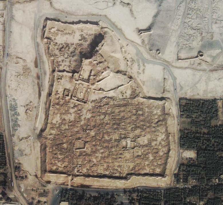
This one-meter resolution satellite image of Bam, Iran was taken by Space Imaging's IKONOS satellite on Dec. 27, 2003, just one day after a catastrophic earthquake struck the historic city. The full image shows widespread destruction as a result of the 6.7 magnitude earthquake that leveled 70 percent of the buildings according to news reports.
Clearly seen in the center of the image (see thumbnail below) is the 2,000-year-old citadel, considered the world's largest mud fortress. According to news reports, much of the medieval fortress crumbled like a sand castle when the quake hit. The citadel was a popular tourist attraction and is on the register of the U.N. Educational, Scientific and Cultural Organization and has been a World Heritage site.
Bam is located about 1,000 km (620 miles) southeast of Tehran.
Photo Credit: Space Imaging
http://www.fas.org/irp/imint/bam_quake.htm
Maintained by Steven Aftergood
Updated December 29, 2003
TOPICS: Extended News; Foreign Affairs; Miscellaneous; News/Current Events
KEYWORDS: bam; image; iranearthquake; iranquake; satellite
Here's the direct link to the full sized picture...it's a biggie.
Bam, Iran
Or click the smaller picture in the article.
The mud fortress was interesting to me as well as a series of round, cone like structures near the top. They kinda look like small volcanos but probably man made. I'm wondering what they are. Ovens...metal working furnaces...wells????
FWIW here's a picture of the fortress before the quake.

And here's a link to some others.BAM pics
Pretty impressive for something built out of mud a couple of millenia ago.
prisoner6
1
posted on
12/30/2003 11:53:43 PM PST
by
prisoner6
To: prisoner6
Thanks for posting that, it's incredible the amount of damage.
To: prisoner6
Thank you for the link to the before pictures. This is so sad, all of that beauty and time, gone in minutes.
3
posted on
12/31/2003 12:00:37 AM PST
by
texasflower
(in the event of the rapture.......the Bush White House will be unmanned)
To: prisoner6
Do you see the citadel in the big picture?
Where is it?
4
posted on
12/31/2003 12:10:07 AM PST
by
DefCon
To: prisoner6
To: prisoner6
placemarker
6
posted on
12/31/2003 12:17:02 AM PST
by
Dianna
To: prisoner6
I think I found it.
Pretty much dead center judging by the scroll bars.
7
posted on
12/31/2003 12:17:12 AM PST
by
DefCon
To: prisoner6
"...Pretty impressive for something built out of mud a couple of millenia ago..."
- - -
While it is a tradgedy, it is apparently is not as old as you think it is.
from your "other bam pics link":
:...most of what remains was built during the Safavid period (1502-1722)..."
8
posted on
12/31/2003 12:23:01 AM PST
by
DefCon
To: DefCon
Yuppers...that's it. It's in the small pic as well.
prisoner6
9
posted on
12/31/2003 12:35:14 AM PST
by
prisoner6
( Right Wing Nuts hold the country together as the loose screws of the left fall out!)
To: Cultural Jihad; prisoner6
Thanks for the larger hyper link.
How shocking.
All gone in a matter of seconds. It was so beautiful, and had stood for all that time.
Of course, the devastating loss of life is heartbreaking (just read it could reach 50,000!) but this is an awesome display of the power of this quake. Puts it into perspective.
To: prisoner6
Madcow hillary has not once been there to say, "I fee yo pain."
11
posted on
12/31/2003 1:12:26 AM PST
by
Waco
To: prisoner6
The mud fortress was interesting to me as well as a series of round, cone like structures near the top. They kinda look like small volcanos but probably man made. I'm wondering what they are. Ovens...metal working furnaces...wells????I think they may be access holes to an underground aqueduct: they tend to follow the water course.
while there IS massive destruction, it also appears that many of the structures did NOT fall down--the newer looking, flat roofed places near the bottom of the picture.
12
posted on
12/31/2003 1:43:23 AM PST
by
Elsie
(When the avalanche starts... it's too late for the pebbles to vote....)
To: Elsie
I think they may be access holes to an underground aqueduct: they tend to follow the water course. That makes lots of sense. I know htey do have underground tunnels from several lakes feeding water supplies to towns and for irrigation.
I noted the same thing with the buildings at the bottom as well.
prisoner6
13
posted on
12/31/2003 2:21:12 AM PST
by
prisoner6
( Right Wing Nuts hold the country together as the loose screws of the left fall out!)
To: prisoner6
If you ever go to Italy, a must visit is the town of Alberobello in Puglia. The houses are built with cone shaped roofs, as is the church.
Brief description:
The trulli, limestone dwellings found in the southern region of Puglia, are remarkable examples of drywall (mortarless) construction, a prehistoric building technique still in use in this region. The trulli are made of roughly worked limestone boulders collected from neighbouring fields. Characteristically, they feature pyramidal, domed or conical roofs built up of corbelled limestone slabs.
For a more historic perspective on Alberobello, go here:
TRULLI


14
posted on
12/31/2003 6:49:18 AM PST
by
NYer
To: prisoner6
bttt
15
posted on
12/31/2003 1:06:54 PM PST
by
Pagey
(Hillary Rotten is a Smug and Holier- than- Thou Socialist)
To: Cultural Jihad
My God.
Disclaimer:
Opinions posted on Free Republic are those of the individual
posters and do not necessarily represent the opinion of Free Republic or its
management. All materials posted herein are protected by copyright law and the
exemption for fair use of copyrighted works.
FreeRepublic.com is powered by software copyright 2000-2008 John Robinson


