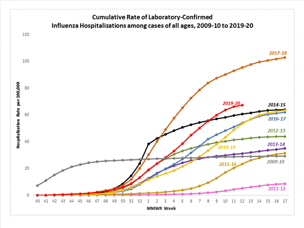
The highest rate of hospitalization is among adults aged ≥ 65, followed by children aged 0-4 years and adults aged 50-64 years.
More info about the graph and hospitalizations at link.
Look at the yellow-green graph on the same page. The graph contradicts the map, in my mind.
Hmm, that’s interesting. The two maps both purport to be the end of week 12 which ends March 21. The difference appears to be the reporting departments/agencies/whatever.
First map with lots of red:
ILI Activity Map
Data collected in ILINet are used to produce a measure of ILI activity* by state.
During week 12, the following ILI activity levels were experienced:
High – the District of Columbia, New York City, Puerto Rico, and 34 states (Alabama, California, Colorado, Connecticut, Georgia, Illinois, Kansas, Kentucky, Louisiana, Maine, Maryland, Massachusetts, Michigan, Minnesota, Mississippi, Montana, Nebraska, New Jersey, New Mexico, New York, North Carolina, North Dakota, Oklahoma, Oregon, Pennsylvania, South Carolina, Tennessee, Texas, Utah, Vermont, Virginia, Washington, West Virginia, and Wisconsin)
Moderate – 10 states (Arkansas, Hawaii, Idaho, Indiana, Iowa, Missouri, Nevada, Ohio, South Dakota, and Wyoming)
Low - two states (Alaska and Delaware)
Minimal - four states (Arizona, Florida, New Hampshire, and Rhode Island)
Data were insufficient to calculate an ILI activity level from the U.S. Virgin Islands
A Weekly Influenza Surveillance Report Prepared by the Influenza Division
Influenza-Like Illness (ILI) Activity Level Indicator Determined by Data Reported to ILINet
Second map showing much less flu activity for same time period, aha, shows spread not severity:
The influenza activity reported by state and territorial epidemiologists indicates geographic spread of influenza viruses but does not measure the severity of influenza activity.
During week 12, the following influenza activity was reported:
Widespread – Puerto Rico and 38 states (Alabama, Colorado, Connecticut, Delaware, Georgia, Idaho, Illinois, Indiana, Iowa, Kansas, Kentucky, Louisiana, Maine, Maryland, Massachusetts, Michigan, Mississippi, Missouri, Nevada, New Hampshire, New Jersey, New Mexico, New York, North Carolina, Ohio, Oklahoma, Oregon, Pennsylvania, Rhode Island, South Carolina, Tennessee, Texas, Utah, Vermont, Virginia, Washington, West Virginia and Wisconsin)
Regional – 10 states (Arizona, Arkansas, California, Florida, Minnesota, Montana, Nebraska, North Dakota, South Dakota and Wyoming)
Local – the District of Columbia and two states (Alaska and Hawaii)
Sporadic – the U.S. Virgin Islands
Guam did not report.
A Weekly Influenza Surveillance Report Prepared by the Influenza Division
Weekly Influenza Activity Estimates Reported by State and Territorial Epidemiologists*
*This map indicates geographic spread and does not measure the severity of influenza activity.
The highest rate of hospitalization is among adults aged ≥ 65, followed by children aged 0-4 years and adults aged 50-64 years.
More info about the graph and hospitalizations at link.