Woolsey Fire Crisis Map Google.com
Apologies for the link to Google. :( It was the easiest map to find.
According to the map. None of the roads you mentioned are open. And given that the winds are supposed to be kicking up again. I’d say that will probably not change in the next 24 hours.
I checked the Caltrans site.
Says open, smokey in patches.
Has a photo.
Check it.
http://www.dot.ca.gov/serp.html?q=calabasas
Have you tried MapQuest???
They often have yellow and red spots on routes denoting traffic conditions?
Don’t know about road closures though.
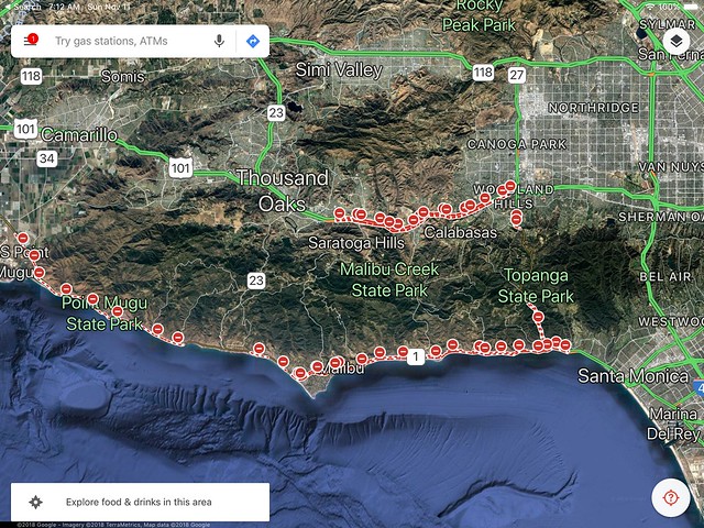
Google traffic shows it closed. As is the PCH. 118 shows open at this point.
https://www.google.com/maps/place/Calabasas,+CA/@34.1284821,-118.8938759,10z/data=!4m5!3m4!1s0x80c29e2317efd3c1:0x61a2e2c26fe615ae!8m2!3d34.1367208!4d-118.6614809!5m1!1e1
Per KNX east bound lane was open
Thanks for your replies. Thousands travel daily from LA areas North and thousands from the North, travel South to LA via Hwy 101. Any impact, you bet. And what about Rail service ?
Alternate routes, yes, but where, which way, how long?
As far as Hwy 101 closures are concerned found this SIGALERT. Check it out.
https://www.sigalert.com/map.asp?lat=34.19026&lon=-118.85515&z=2
I have friends who live in Calabasas, not sure how their house is doing..I am concerned about the Pet Cemetery that is in the area(Our pup Nemo is buried there) I have not heard anything about the cemetery maybe you can find out some info about it. I believe its near Parkway Calabasas(North of the 101) Have honestly not been able to sleep worrying about him since this is his final resting place. Hope all is well with your home. Have a cousin who lives in Zuma Beach she evacuated, this morning her next door neighbor’s house burned down but her house is fine so far
Not as of an hour ago.
Sigalert - hover your cursor over the red line and the camera icons
https://www.sigalert.com/?lat=34.21273&lon=-118.67016&z=0