I marched to Alley Hall on a Friday to escape Elena and was released when it headed for Tampa.
I flew home and that damn thing turned and hit Biloxi. I was the second plane in to see the destruction.
It took two weeks to get the town in order and another two weeks to get the base in order. Thank You to those in the USN that know what I’m talking about.
eye
Matthew to Arrive 4,000 days after Last Major Hurricane
http://www.drroyspencer.com/2016/09/matthew-to-arrive-4000-days-after-last-major-hurricane/
29SEP2016
Updated 1OCT2016
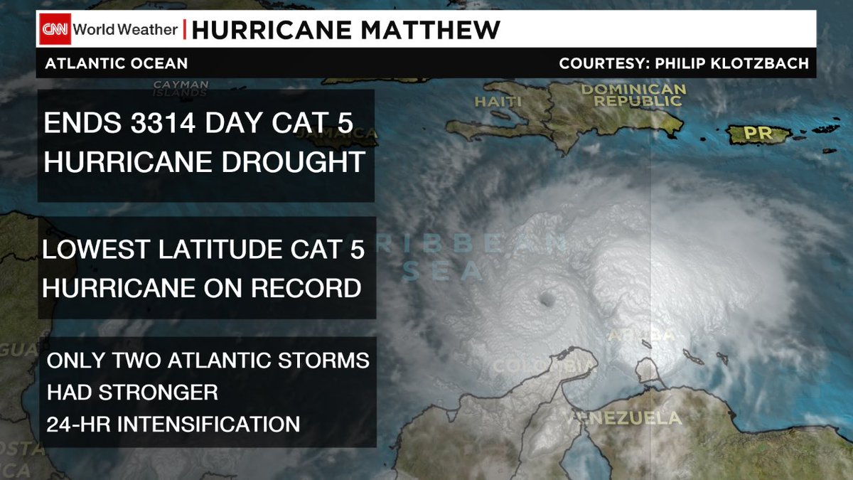
Major Hurricane Matthew was briefly a Category 5 hurricane overnight, the first Cat 5 in the Atlantic in nine years. It now has 155 mph sustained winds, making it a strong Category 4 storm on the Saffir-Simpson scale.
Matthew is over the south-central Caribbean, traveling slowly westward, but a turn to the north is expected on Sunday. Matthew is expected to cross eastern Cuba Tuesday morning and possibly make U.S. landfall somewhere on the East Coast around next Friday or Saturday.
Thursday will mark exactly 4,000 days after Major Hurricane Wilma’s landfall.
Hurricane Wilma, the last major hurricane (Cat 3 or stronger) to hit the U.S., struck Florida on October 24, 2005. Will Matthew arrive as the first major hurricane to strike the U.S. in almost 11 years? Only time will tell. (Sandy was Cat 1 at landfall, and technically not a hurricane at that time. Hurricane Ike, 2008, was a Cat 2.)
Here is the latest GFS model forecast for Matthew on midnight Sunday, Oct. 9 (graphics courtesy of Weatherbell.com): (see pic at link)
That particular forecast, which remains very uncertain this far in advance, has Matthew making landfall at Cape Hatteras, Cape Cod, and then going inland in Maine. Here is the spread of model forecasts from NOAA’s GEFS ensemble forecast system: (see pic at link)