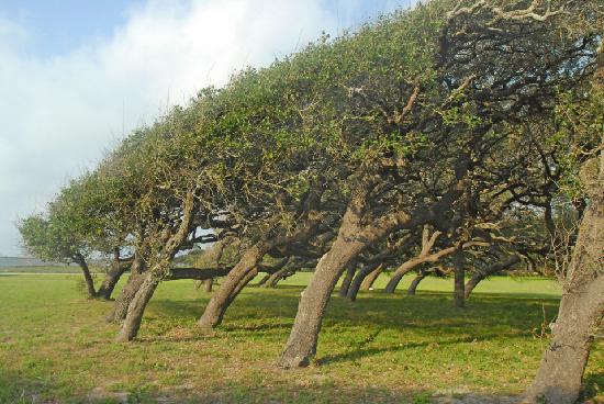
This photo of Rockport is courtesy of TripAdvisor.
Posted on 11/17/2013 9:27:48 AM PST by Pan_Yan
As wonderful and useful as our modern technologies are, there are still plenty of places in this world where Mother Nature rules supreme. One such place is Slope Point in New Zealand.
Slope Point is the southernmost tip of New Zealand’s South Island. It lies 4800 km (2982 mi) from the South Pole and 5100 km (3168 mi) from the equator, so it’s regularly exposed to unimaginable weather conditions. The air stream loops that travel over the Southern Ocean uninterrupted for 3200 km (2000 mi) make landfall at Slope Point, making for consistently extreme winds. And yet, even in this uniquely harsh environment, extraordinary beauty can be found.
The extreme winds that batter Slope Point are so strong and consistent that the trees that grow there are molded into strangely and beautifully twisted forms. The trees themselves would not exist there if not for the sheep farmers that live nearby. Although Slope Point itself is almost uninhabited and is only reachable my foot, nearby farmers’ sheep graze there. The farmers raised small groves of hardy trees to offer their livestock some respite from the strong winds.
Writer Trevor Cree described the area like this: “It is not a wind that will necessarily break and snap at will, although clearly it can, it is its sheer relentlessness, like a gnawing toothache, that never ceases until total submission from the victim is achieved.“
(Excerpt) Read more at boredpanda.com ...
wow. not a place for rubber boats thats for sure
From my perspective, that’s a nice, warm, calm predictable climate at a low elevation. Looks comfortable and arable. So sheep can live without shelter there. That’s something. Here, last night, 100+ mph gusts from various westerly directions with temps below 20 F and a little spraying ice. No trees here. Before long, it will be way below 0 with windy days most of the time. Many days with gusts over 80 mph and a few each winter with gusts over 100 carrying the spraying ice.
There’s nothing between Antarctica and NZ but open ocean.
That sign is a little off. In Google Earth I get latitude and longitude of 46 40 30 S and 169 00 07 E . Well, who knows, right?
But I also measured the distances and got 5171 and 4831, vs.
5140 and 4803 on the sign. The polar circumference is 40008, which I hit on the nose with Google Earth, finding 10002 for one quarter of it. Honestly, I did not have this number in mind when I made the measurements! The sign values add to 9943, of course.
Only after I looked it up did I recall that the original definition of the meter was the distance from the north pole to the equator, through Paris, of course!
BTW, this latitude corresponds almost exactly to Duluth, MN, mutatis mutandis.
Also BTW, when I was dragging the GE “ruler” to the south pole, I went directly through New Zealand’s Scott Base, adjacent to McMurdo Station.
(Ahem)
Between Rockport and Fulton, Texas…
"This part of the Texas coastline also features large windswept mottes of live oaks. The beauty of each tree has been slowly shaped and carved by the prevailing winds along this part of the coastline. Though short in stature and bent by the wind they still hold for us a unique stately grace."
Beautiful.
I was trying to account for this discrepancy, and I did find that if the correct values in miles were converted to kilometers using a factor of 1.6 instead of the more correct 1.60934, we should recover the correct sum in kilometers by multiplying 9943 by 1.60934/1.6, and in fact this comes to 10001.04, so I'm gonna say that's it and call it a day.

Disclaimer: Opinions posted on Free Republic are those of the individual posters and do not necessarily represent the opinion of Free Republic or its management. All materials posted herein are protected by copyright law and the exemption for fair use of copyrighted works.