Skip to comments.
Hurricane Sandy Will Not Land in the US (10-23-12)
WeatherAction.Com ^
| 23 October 2012
| Piers Corbyn
Posted on 10/28/2012 10:04:32 PM PDT by Fractal Trader
Piers Corbyn's Weather prediction

(Excerpt) Read more at twitpic.com ...
TOPICS:
KEYWORDS: hurricanesandy; weather
Navigation: use the links below to view more comments.
first previous 1-20 ... 61-80, 81-100, 101-120 ... 301-313 next last
To: PA Engineer
Another oddity is that it’s going to be over 60 degrees tomorrow and most of the week at Timberline on Mt. Hood, at 6,000 ft. Should be a bunch chillier there, by now. In ten days it should be down to around 45 but ski season other than the permanent snow field is going to have to wait a while longer.
81
posted on
10/28/2012 10:57:31 PM PDT
by
steve86
(Acerbic by nature not nurture TM)
To: Gabz
you didn’t exactly blow off the poster last night claiming it was being made up by an Obama government agency. I've had my eye on Sandy before it even entered the Caribbean just as I do all storms west of Africa between June and December (Hurricane Season).
It's not my job to "blow off" everybody on FR that believe in conspiracy theories, quote Alex Jones or watches Glenn Beck.
82
posted on
10/28/2012 10:57:31 PM PDT
by
tsowellfan
(KEEP WORKING like we are 10 POINTS DOWN!!!!)
To: Errant
>>>75 mph winds, not so much... Surge - N.O. experienced a 30' surge during Katrina. Almost three times your highest prediction of 11' at high tide.
NOLA did not experience a 30' storm surge. The max surge was 27' on the MS coast. Max surge in and around NOLA was 12-16'. Surge was 12' at Lakefront.
But...its apples and oranges. You can't compare surges from one place to another as if they are all the same. A 14' surge over Miami would do MASSIVE amounts more damage than say a 30' surge along the MS/AL coasts...or in Chambers County TX.
A 12' surge at Kings Pt and 11' at Battery Park will cause a LOT of damage...much more than 12' in MS.
To: GeronL
You can’t possibly be serious ........
84
posted on
10/28/2012 10:57:50 PM PDT
by
Gabz
(Democrats for Voldemort.)
To: Fractal Trader
Well the 2am report has it leaving its NE path and turning North, so its doing everything they said it would at this point.
85
posted on
10/28/2012 10:58:54 PM PDT
by
eak3
To: Gabz
The flood waters and damage already documented have already proven this storm is not the figment of anyone’s imagination or some government conspiracy. No one's saying that there isn't any storm... some are just suggesting that it might not be the biggest meanest storm in the history of mankind.
To: PA Engineer
The positions for 3am and 6am GMT on the map are both Longitude -70.50 so the storm is moving due North.
87
posted on
10/28/2012 10:59:48 PM PDT
by
deks
("...the battle of our time is the battle of liberty against the overreach of the federal government")
To: GeronL
88
posted on
10/28/2012 10:59:59 PM PDT
by
tsowellfan
(KEEP WORKING like we are 10 POINTS DOWN!!!!)
To: PA Engineer
The Euro has been the BOMB for this storm. Even when the NHC was worshiping the GFS I felt the EURO had it right. No doubt the Euro won this round.
To: Gabz
He missed the day sixth grade went to the planetarium and saw the moon and sun on nearly opposite sides of the earth. Then missed science class in the 8th when they learned the word “syzygy”.
90
posted on
10/28/2012 11:01:53 PM PDT
by
steve86
(Acerbic by nature not nurture TM)
To: NELSON111
I agree, it is a rare occurrence, and although the eye is a little bit east of the bulk of the model tracks, it's still going to send some serious surge waters into the NJ, NY area.
It's looking more to me like the eye may just hit around NY city, but that's just a wild guess at this point.
91
posted on
10/28/2012 11:02:33 PM PDT
by
Pox
(Good Night. I expect more respect tomorrow.)
To: PA Engineer

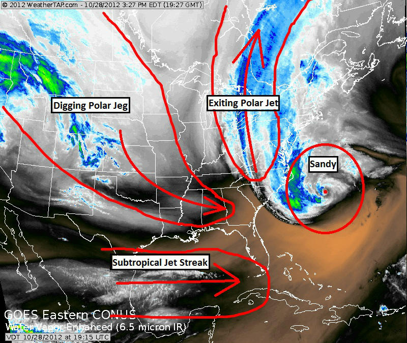
Three powerful jet streams colliding at the same time. This would have been a powerful Nor'easter without the hurricane; you throw in the hurricane and its low pressure with these ingredients, and for one of the few times in my life I will be saying tomorrow: OMG!
92
posted on
10/28/2012 11:02:43 PM PDT
by
hawkeye101
(Ron Paul attacked every Republican in the 2012 race EXCEPT for Mitt Romney.)
To: NELSON111
I agree with you, the EURO has been the best on this.....and I’m not a meteorologist, just a bit of a weather geek.
Thanks for your voice of sanity on this thread.
93
posted on
10/28/2012 11:02:52 PM PDT
by
Gabz
(Democrats for Voldemort.)
To: eak3
“the 2am report”
What website are you using to get the position please?
94
posted on
10/28/2012 11:03:04 PM PDT
by
deks
("...the battle of our time is the battle of liberty against the overreach of the federal government")
To: Gabz
Get a hatchet and punch a hole through the roof. Make a quick stop at Hardees and get a bunch of biscuits. Get yourself back toot sweet and make sure the news is on so you know when to get out of the smartly prepared hole in the roof. Don’t forget the biscuits.
95
posted on
10/28/2012 11:03:32 PM PDT
by
eyedigress
((zOld storm chaser from the west)/?)
To: steve86
Another oddity is that it’s going to be over 60 degrees tomorrow and most of the week at Timberline on Mt. Hood, at 6,000 ft. Should be a bunch chillier there, by now. In ten days it should be down to around 45 but ski season other than the permanent snow field is going to have to wait a while longer.
I am watching the anomalies. Very unsettled for this time of year.
Something else that is troubling me. I know I don't want to be in West Virginia this week. Two plus feet of wet snow. That is going to be another tragedy.
96
posted on
10/28/2012 11:04:15 PM PDT
by
PA Engineer
(Liberate America from the Occupation Media.)
To: deks
Sorry .. watching The Weather Channel.
97
posted on
10/28/2012 11:05:11 PM PDT
by
eak3
To: GeronL
After living in Florida for 13 years and having been through several hurricanes, I’ve gotten used to tracking these things even though I’m in Southern California now.
The NE is really going to catch a lot of flooding that will cost taxpayers an awful lot of money to clean up.
98
posted on
10/28/2012 11:06:54 PM PDT
by
Pox
(Good Night. I expect more respect tomorrow.)
To: hawkeye101
Three powerful jet streams colliding at the same time. This would have been a powerful Nor'easter without the hurricane; you throw in the hurricane and its low pressure with these ingredients, and for one of the few times in my life I will be saying tomorrow: OMG!
I like it. It hit me on Tuesday that something was really wrong. Started cycling fuel and contacting loved ones. Just hope I can get across the Laurel Ridge if I have to pick up my daughter from Happy Valley.
99
posted on
10/28/2012 11:08:13 PM PDT
by
PA Engineer
(Liberate America from the Occupation Media.)
To: Cementjungle
No one's saying that there isn't any storm... some are just suggesting that it might not be the biggest meanest storm in the history of mankind. Actually there have been some saying there is no storm and the "storm" has been made up by the Obama controlled government agency NOAA who have been ordered to make a normal rain event look like Armageddon.........
It may not be the biggest or meanest in history - but it is one weird system. Hurricane/tropical storms morphing into a nor'easter is not exactly something seen very often.
100
posted on
10/28/2012 11:08:21 PM PDT
by
Gabz
(Democrats for Voldemort.)
Navigation: use the links below to view more comments.
first previous 1-20 ... 61-80, 81-100, 101-120 ... 301-313 next last
Disclaimer:
Opinions posted on Free Republic are those of the individual
posters and do not necessarily represent the opinion of Free Republic or its
management. All materials posted herein are protected by copyright law and the
exemption for fair use of copyrighted works.
FreeRepublic.com is powered by software copyright 2000-2008 John Robinson


