Well, you can feel real good since nature has given you your wishes for my town several times over.
Lawn Lake dam break inundated Estes Park
Happy now? If not, here's a quarter. Go buy yourself a sense of humor.

Posted on 08/27/2017 7:33:37 PM PDT by davikkm
Maybe it is not the intensity NOAA is referring to, it’s the lack of movement with this storm. Instead on moving on it is meandering just offshore where it continues to pick up moisture which is then dropped as rainfall over the area. 50 inches of rain in four days over a major metro area in the US might be unprecedented.
Lighten up. No one said anything about climate change. Its just a massive storm that will have catastrophic consequences for the people living through it.
Your weird need to categorize it as “just another storm” is just flat out wrong.
50 INCHES of rain?? In one storm?? “Just another storm”? Talk to someone who is in Houston right now. See what they have to say.
Thank you.
Really? Point out the Hurricane that dumped up 30+ inches of rain on a large metropolitan area and then hung around for 4-5 days.
They hype a lot of them. This one, they didn’t. This is going to cause tens of billions of dollars in damage. Or more.
Here in Dallas it’s mainly been overcast, but the temperatures are only expected in the mid-80s, which is unheard of this time of year. We are usually well over 100 at this time of year.
My point? No matter what word you use to modify this storm, it's still a storm. It is NOT the unprecedented event that the professional doomsayers are making it out to be, yet we both know the Left (to attack Trump) will claim it as such. I will not be part of this narrative.
And by the way, the storm has dumped 20+ inches of rain, not 50. Yes, that's a lot of water, but again, it's hardly unprecedented for a tropical storm at this time of year.
Amelia, 1978.
48 inches.
Next
Exactly. Ocean waves were breaking two miles inland during Sandy. Supermarkets were cleared out. People were in dire straits. These crazy storms are unpredictable. It ticks me off when rats play politics while people are suffering.
Bite me, Mr. Literal.
CALLER: What I can tell, it’s not. So it’s just certain neighborhoods — that were just a little bit low that got hit hard.
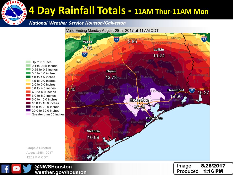
...Liberty County... Dayton 39.72 in 0700 AM 08/28 30.05N/94.89W
All other totals at the link.
http://www.wpc.ncep.noaa.gov/discussions/nfdscc1.html
AT 300 PM CDT...THESE ARE THE MOST RECENT RAINFALL AND WIND
REPORTS FROM TROPICAL STORM HARVEY. PLEASE REFER TO NHC FOR THE
LATEST PUBLIC ADVISORIES ON HARVEY.
...SELECTED STORM TOTAL RAINFALL IN INCHES FROM 800 PM CDT THU AUG
24 THROUGH 300 PM CDT MON AUG 28...
...TEXAS...
FIRST COLONY 4 WSW 35.01
WALLER 3.0 WSW 34.90
MISSION BEND 5.6 NNW 34.30
LEAGUE CITY 2 W 33.96
DIXIE FARM ROAD 32.32
FULSHEAR 3 NE 31.75
BERRY B FOREST OAKS 31.56
BROOKSHIRE 6.9 NNW 30.90
ALVIN 3 SW 30.89
CLEAR CREEK NEAR FREINDSWOOD 30.76
SOUTH HOUSTON 4.0 SSW 30.32
SANTE FE 0.7 S 30.25
MARYS CREEK AT MELODYWOOD 30.20
DAYTON 4 NW 30.17
BEAMER DITCH HUGHES RD 30.08
CLEAVELAND 3.6 S 29.96
CLOVERLEAF 1.7 W 29.90
KATY 1 NNE 29.75
PECAN GROVE 29.17
RICHMOND 2.9 NE 29.17
LA GRANGE 10.2 NW 29.09
SMITHVILLE 9 E 29.09
GOOSE CREEK AT BAKER ROAD 29.04
LITTLE VINCE BAYOU 28.84
KATY 9.3 NE 28.73
ARMAND BAYOU 28.52
TOMBALL 5 NNE 28.14
GUM GULLY AT DIAMOND HEAD 28.08
PECAN GROVE 1 NNW 27.95
LITTLE CEDAR BAYOU 27.76
MONT BELVIEU 1 NNW 27.57
BAYTOWN 2 NW 27.32
ADDICKS RESERVOIR 27.24
MULDOON 2 NE 26.63
CARMINE 3.1 WNW 26.37
HUNTING BAYOU 26.13
TELEPSEN 25.91
PASADENA 2 ESE 25.63
LITTLE MOUND CREEK AT BETKA 25.20
SUGARLAND 25.16
WALLER 7 ESE 25.13
COUNTRY CLUB DRIVE 25.12
JACINTO CITY 25.00
HOUSTON/INTERCONTINENTAL 24.79
COLUMBIA 9 NNE 24.73
MAGNOLIA 2 S 24.65
ELLINGER 7 E 24.63
HOUSTON/WILL HOBBY 24.47
BUFFALO BAYOU AT US 90 24.36
KATY 7 E 24.36
BELLVILLE 24.13
COLDSPRING 5 SSE 23.98
HUNTSVILLE 11 WSW 23.80
NEEDVILLE 8 SE 23.66
HILLCREST 2 ENE 23.34
NEW ULM 0.1 ENE 23.26
CALDWELL 23.12
HUFSMITH 22.52
MISSION BEND 2 W 22.40
FAYETTEVILLE 1 SW 22.04
HOUSTON/D.W. HOOKS 22.04
SMITHVILLE 21.88
BURTON 6 ESE 21.39
SHENANDOAH 4 NNW 21.32
SMITHVILLE 5 NNW 21.05
GONZALES 9 SW 20.91
TOMBALL 1 N 20.88
LA GRANGE 4 NE 20.87
GREATWOOD 20.40
CARMINE 20.38
SPINDLETOP BAYOU @ STATE HIGHWAY 20.08
COLLEGE STATION 2SSW 19.64
HOUSTON/CLOVER FIELD 19.04
BASTROP 6 SW 18.85
STOWELL 8 SSW 18.30
SOMERVILLE 1 SSE 16.82
HAMSHIRE 3 NE 14.00
COLLEGE STATION 2 ENE 13.92
GALVESTON/SCHOLES 10.41
AUSTIN 4 SSE 10.28
In my last comment, those were only rainfall totals from some NOAA-approved stations. The NOAA does not use all of its certified stations in its data sets and reports (politics, tourism, etc., examples: Antero Reservoir in CO, -51F one night in December, 2015, data sets from Hurricane Celia in Corpus Christi in 1970, anemometers broken, revisions after Hurricane Andrew, insurance-builder interest dilemma, shoddy buildings not to code on roof structurals and wind straps). Also, some non-certified stations are good but omitted from data sets and reports.
I wish I could.
You are a colossal idiot. A flaming, unmitigated idiot.
You a Log Cabin Republican or just a drama queen?
Well, you can feel real good since nature has given you your wishes for my town several times over.
Lawn Lake dam break inundated Estes Park
Happy now? If not, here's a quarter. Go buy yourself a sense of humor.
Some people will fall for anything the MSM tells them.
He's either at the bathhouse or engrossed in putting his mascara on.
Courtesy ping to the queer.
Disclaimer: Opinions posted on Free Republic are those of the individual posters and do not necessarily represent the opinion of Free Republic or its management. All materials posted herein are protected by copyright law and the exemption for fair use of copyrighted works.