I knew humans came out of the Americas after I seen this map. Ophir (19 on map 1572 AD)
Ophir was the one that shipped the gold to King Solomon & Noah's great grand son
https://raremaps.com/gallery/detail/93232/world-first-state-benedict-arias-montanus-sacrae-geogra-montanus Think of the logistics of knowing these location pre-flood(younger dryas/Utnapishtim the king that told the story of the flood from Gilgamesh.
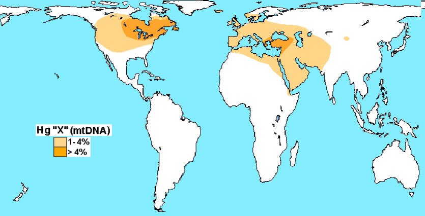
Haplogroup-X or Cro-Magnon IMO phrased the root race is correct. how can they originate in both in Anatolia and Americas?
Generally I believe Cro-magnon was traveling to and from these locations pre-younger dryas. Though there is more to this because the North pole before the younger Dryas was in Greenland the area would be to cold IMO. The location they lived around today the Great lakes was ground zero for the impact of the younger Dryas. Which is odd in itself.
i have more including writing in South America that is rooted in Sumerian.
And the map keeps changing. There is a large area of Eastern Oregon, Southern Idaho. N.Nevada, clear to the Rockies by the Great Salt Lake known as the Great Basin. It was once full of water to about 5,000 feet elevation. All that’s left is Salt Lake and Malheur lake in Oregon. It started draining when the Columbia Gorge broke thru.
The University of Oregon has a dig going on the high water mark in Eastern Oregon. So far they’ve dated their hole to 18,000 years and they’re still digging. They haven’t published details yet but have found tools, etc. pretty much all the way down. What they’ve published so far has pushed back the old genius estimates for the area by over 10,000 years. Interesting side note is that when the water level was high there was not much dry land. Just islands made by the high peaks. So they seem to have eaten more fish than game.
Someplace down that hole they’ll probly find an old Ford factory? Could be where the Egyptians got their enviro friendly chariots?