To: SunkenCiv
Ping, not Ukraine.
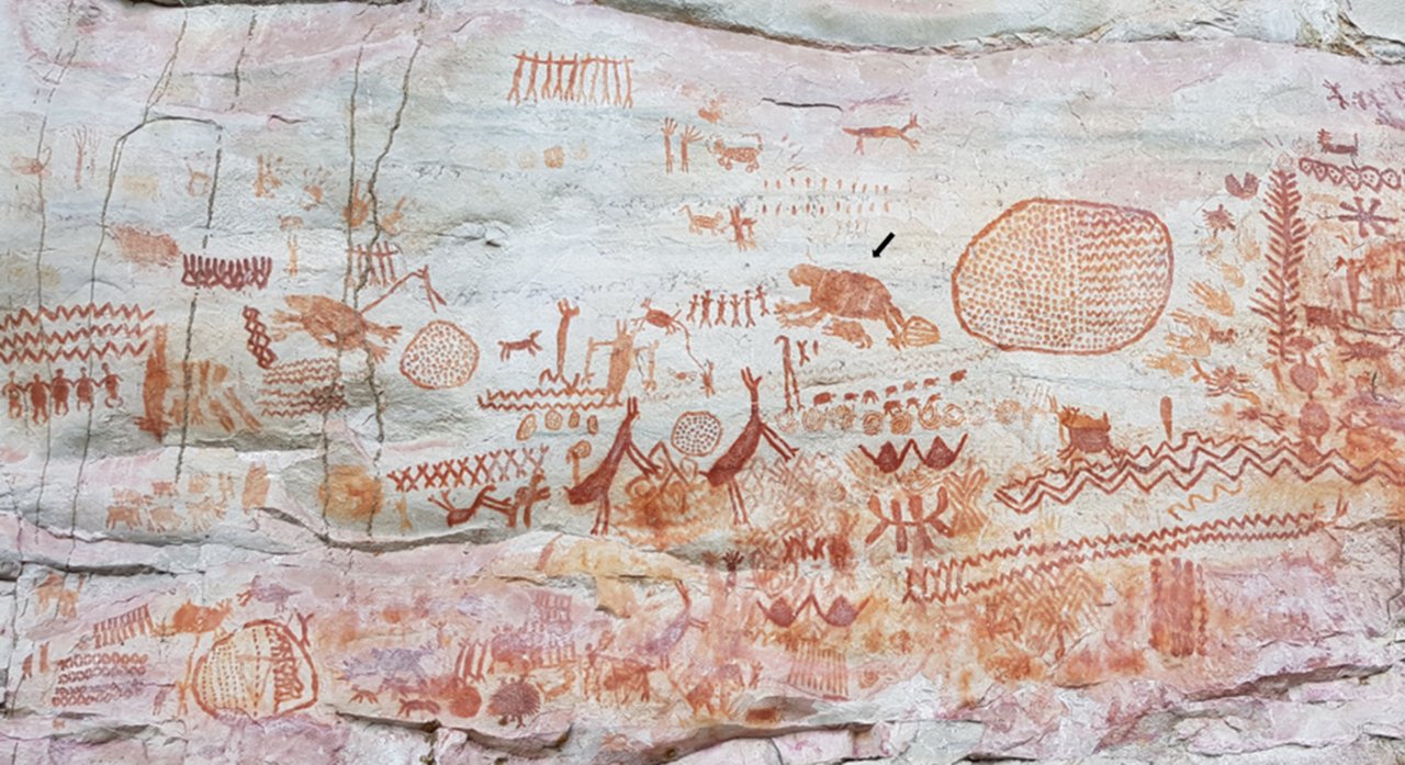
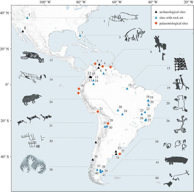
Figure 1. Map of the Americas showing most important LP-EH archaeological, rock and portable art, and palaeontological sites mentioned in the text where Ice Age megafauna has been documented or portrayed: 1. Upper Sand Island site; 2. Fin del Mundo; 3. Vero Beach; 4. Ware Formation; 5. Taima-Taima; 6. Lake Valencia; 7. El Breal de Orocual; 8. El Vano; 9. Cerro Gavilán; 10. Totumo; 11. Pubenza; 12. Tibitó; 13. Serranía la Lindosa; 14. Chiribiquete; 15. Caverna da Pedra Pintada; 16. Tanque Loma; 17. Talara; 18. Serra da Capivara; 19. Toca da Bastiana; 20. Bahia; 21. Casa del Diablo; 22. Lapa do Boquete; 23. Lapa do Gentio; 24. Santa Elina; 25. Santana do Riacho; 26. Lapa do Santo; 27. Lagoa Santa region; 28. Abrigo do Sol; 29. Tarija; 30. Inca Cueva; 31. Hornillos 2; 32. Los Vilos; 33. Campo Laborde; 34. Arroyo Seco 2; 35. Centinela del Mar; 36. Monte Verde; 37. Cueva de las Manos; 38. Los Toldos; 39. Piedra Museo; 40. Cerro Tres Tetas; 41. El Ceibo.
2 posted on
03/07/2022 7:03:30 PM PST by
Theoria
To: Theoria
3 posted on
03/07/2022 7:03:57 PM PST by
Theoria
To: Theoria
The arrow looks like it is pointed to a giant sloth.
6 posted on
03/07/2022 7:20:47 PM PST by
Jonty30
(How can you claim to help me with my healthcare costs when you can't pay for your own?)
To: Theoria
Odd that Texas is not included in figure 1 for all three categories.
11 posted on
03/07/2022 7:49:16 PM PST by
Deaf Smith
(When a Texan takes his chances, chances will be taken that's for sure.)
To: Theoria
Look at the drawings at #39...PAC MAN!!
13 posted on
03/07/2022 8:01:07 PM PST by
GrandJediMasterYoda
(As long as Hillary Clinton remains free, the USA will never have equal justice under the law)
To: Theoria
I like the 10 guys at the top, carrying the python.....
15 posted on
03/07/2022 8:04:04 PM PST by
G Larry
(Tolerance will rise until intelligent people are banned from thinking to avoid offending imbeciles)
To: Theoria
I came across some petroglyphs today while out on a hike. I had hiked past that rock many times before, but had never stopped to look at it very closely. I located a spiral, a sun, either a lizard or a dude with a huge phallis, a family (man woman, child) all holding hands. Then I found a hunting scene: three deer with antlers, what looked like a dead coyote upside down (or maybe this was a small deer, not sure), and two hunters with their arms up (assuming this means successful hunt). Next to the hunt scene was what looked like a Turtle Clan mark that was encircled. So the Turtle clan had a good hunt that day, I assume. I love finding petroglyphs!
27 posted on
03/07/2022 10:10:40 PM PST by
ponygirl
(An Appeal to Heaven )
FreeRepublic.com is powered by software copyright 2000-2008 John Robinson