- Watch this:

Secretary Clinton Announces the TIGHAR Search Published on Mar 27, 2012
They said:
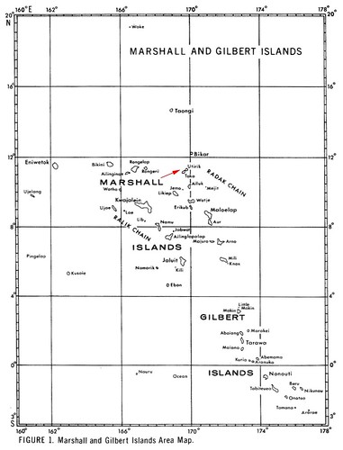 It was on the north end of Utirik Island, or Chirubon Island, not Mili Island.
Most of the wreckage was in the tree line, and on the beach, and it was part of one wing and a piece of the tail.
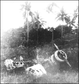
Pieces were in the water between the island and the coral reef.
Local Utirik Island people said the Japanese towed the aircraft beyond the reef and told them they would sink it.
My friends said they did not see any large pieces of the aircraft beyond the reef.
But my friends said there's enough wreckage on the tree line and on shore that they took photo's, during the mid 1980s, and sent them to the University of Michigan for identification.
The University of Michigan wrote them that it was an Electra type aircraft, but there were no serial numbers that could positively identify that wreckage as Amelia Earhart's Electra.
Even though that was over 30 years ago, I feeel sure that someone could go back to the north end of Utirik Island or Chirubon Island and find that wreckage.
Now consider A compilation of radio messages and eyewitness sightings of Amelia Earhart and Fred Noonan in the Marshall Islands and on the island of Saipan using Noonan's injuries as a common thread.
- “On July 3rd, 1937 at 2:20 PM EST, I picked up Amelia Earhart's distress signal by short wave.
This message contained some 300 to 400 words-
- in which she described Mille or Mulgrave atoll, Klee Passage, Knox island and seemed to be located on a small island of 133 acres adjoining Knox, directly NE of a part of Marshall Island”.
On the 5th of July. Nina picked up an SOS giving 177 longitude.... and 58 minutes above the equator.
The radio was fading in and out so the coordinates were partial.
Just for fun, I took those numbers, bought aerial navigation charts from NOAA, and inserted all of the possible number combinations for coordinates in the Marshall Islands to make a complete set of coordinates.
The only place in the Marshalls that I came close to land were the coordinates-
- 172.07 degrees east, 5 hours and 58 minutes north of the equator,
That area is dry at low tide and has about 5 feet of water at high tide.
Several years later I received a copy of Charles N. Hill's book “Fix on the Rising Sun” and noted that his redo of the LOP (line of position), page 140, puts the LOP a few miles east of this location."