Free Republic
Browse · Search
General/Chat
Topics · Post Article

Skip to comments.

Tropical Storm Dolly
NOAA/NHC ^ | 20 July 2008 | NOAA/NHC

Posted on 07/20/2008 8:36:53 AM PDT by NautiNurse

Newly formed Tropical Storm Dolly over the NW Caribbean Sea near 18.4N 84.2W. 1008 MB at 11AM this morning. Max sustained winds 40KT, gusts 50KT, moving NW at 15KT.

Caribbean Buoys

Wunderground Tropical Updates

Visible Satellite image

Infrared Sat Loop


TOPICS: Front Page News
KEYWORDS: dolly; hurricane; tropical
Navigation: use the links below to view more comments.
first previous 1-20 ... 441-460461-480481-500 ... 821-839 next last
To: 1COUNTER-MORTER-68

No ifs, ands or buts about it, this thing is sittin still for now.


461 posted on 07/22/2008 10:19:00 PM PDT by eastforker (Get-R-Done and then Bring-Em- Home)
[ Post Reply | Private Reply | To 458 | View Replies]

To: eastforker

And it appears to be gaining strength.


462 posted on 07/22/2008 10:21:36 PM PDT by eastforker (Get-R-Done and then Bring-Em- Home)
[ Post Reply | Private Reply | To 461 | View Replies]

To: 1COUNTER-MORTER-68
It's possible to have several hundred plus tornadoes caused by one hurricane. Most are small.
463 posted on 07/22/2008 10:22:20 PM PDT by Hillarys Gate Cult (The man who said "there's no such thing as a stupid question" has never talked to Helen Thomas.)
[ Post Reply | Private Reply | To 454 | View Replies]

To: 1COUNTER-MORTER-68
“Studies have shown that more than half of the landfalling hurricanes produce at least one tornado; Hurricane Buelah (1967) spawned 141 according to one study. In general, tornadoes associated with hurricanes are less intense than those that occur in the Great Plains (see the Fujita Intensity Scale below). Nonetheless, the effects of tornadoes, added to the larger area of hurricane-force winds, can produce substantial damage.”

http://www.fema.gov/hazard/hurricane/hu_tornadoes.shtm

A friend told me that Hurricane Hugo generated around 3000 tornadoes but I can't confirm that.

464 posted on 07/22/2008 10:28:25 PM PDT by Hillarys Gate Cult (The man who said "there's no such thing as a stupid question" has never talked to Helen Thomas.)
[ Post Reply | Private Reply | To 454 | View Replies]

To: CindyDawg
LOL. Freep 1st. I'm with ya. Here's my impression:

Since they eye is almost to Brownsville anyways and would have to make an impossible hard left (starting right this minute) to hit ya.

465 posted on 07/22/2008 10:29:54 PM PDT by txhurl
[ Post Reply | Private Reply | To 459 | View Replies]

To: CindyDawg

Mite want to put some of your emergency stuff in there too,,,

Storm has stalled for now...

Toranado warnings off for now...


466 posted on 07/22/2008 10:34:24 PM PDT by 1COUNTER-MORTER-68 (THROWING ANOTHER BULLET-RIDDLED TV IN THE PILE OUT BACK~~~~~)
[ Post Reply | Private Reply | To 459 | View Replies]

To: eastforker

Roger Dat!...


467 posted on 07/22/2008 10:35:46 PM PDT by 1COUNTER-MORTER-68 (THROWING ANOTHER BULLET-RIDDLED TV IN THE PILE OUT BACK~~~~~)
[ Post Reply | Private Reply | To 461 | View Replies]

To: txflake

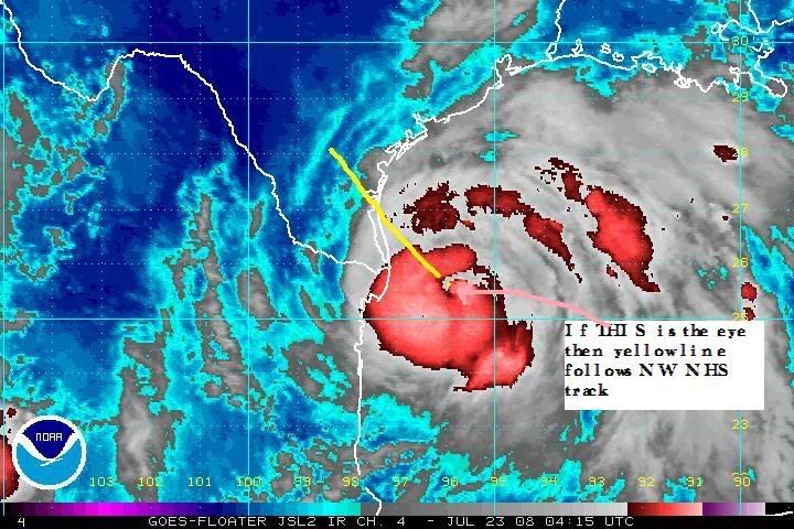
I think the eye is a little further south.Check out this radar http://radar.weather.gov/ridge/radar.php?product=N0Z&rid=bro&loop=yes


468 posted on 07/22/2008 10:36:15 PM PDT by eastforker (Get-R-Done and then Bring-Em- Home)
[ Post Reply | Private Reply | To 465 | View Replies]

To: Hillarys Gate Cult

True,,,

This storm looks like it mite just sit there awhile,,,


469 posted on 07/22/2008 10:40:23 PM PDT by 1COUNTER-MORTER-68 (THROWING ANOTHER BULLET-RIDDLED TV IN THE PILE OUT BACK~~~~~)
[ Post Reply | Private Reply | To 464 | View Replies]

To: 1COUNTER-MORTER-68

I would not be surprised to see that this storm is bordering on a cat 2 right now.


470 posted on 07/22/2008 10:46:42 PM PDT by eastforker (Get-R-Done and then Bring-Em- Home)
[ Post Reply | Private Reply | To 469 | View Replies]

To: eastforker

The people at easternuswx are discussing that.

http://www.easternuswx.com/bb/index.php?showtopic=168960&st=2000


471 posted on 07/22/2008 10:48:10 PM PDT by rdl6989 ( I'm a carbon based human being, a Carbonated-American)
[ Post Reply | Private Reply | To 470 | View Replies]

To: rdl6989

Damn, maybe I missed my calling, LOL!


472 posted on 07/22/2008 10:50:30 PM PDT by eastforker (Get-R-Done and then Bring-Em- Home)
[ Post Reply | Private Reply | To 471 | View Replies]

To: eastforker

That’s what happens when they stall,,,

Eye-wall has closed,,,

I can’t see where it has moved at all...


473 posted on 07/22/2008 10:52:06 PM PDT by 1COUNTER-MORTER-68 (THROWING ANOTHER BULLET-RIDDLED TV IN THE PILE OUT BACK~~~~~)
[ Post Reply | Private Reply | To 470 | View Replies]

To: eastforker

AT 100 AM CDT...0600Z...THE CENTER OF HURRICANE DOLLY WAS LOCATED
NEAR LATITUDE 25.3 NORTH...LONGITUDE 96.3 WEST OR ABOUT 85 MILES...
140 KM...EAST-SOUTHEAST OF BROWNSVILLE TEXAS.

DOLLY IS MOVING TOWARD THE NORTHWEST NEAR 9 MPH...15 KM/HR. SOME
FURTHER DECREASE IN FORWARD SPEED IS EXPECTED TODAY. ON THE
FORECAST TRACK...THE CENTER OF DOLLY WILL BE ALONG THE COAST
NEAR THE TEXAS/MEXICO BORDER AROUND MIDDAY TODAY.

MAXIMUM SUSTAINED WINDS ARE NEAR 80 MPH...130 KM/HR...WITH HIGHER
GUSTS. DOLLY IS A CATEGORY ONE HURRICANE ON THE SAFFIR-SIMPSON
SCALE. WSR-88D DOPPLER RADAR OBSERVATIONS FROM BROWNSVILLE SUGGEST
THAT THE HURRICANE IS BECOMING BETTER ORGANIZED...AND SOME
STRENGTHENING IS EXPECTED PRIOR TO LANDFALL.


474 posted on 07/22/2008 10:52:08 PM PDT by rdl6989 ( I'm a carbon based human being, a Carbonated-American)
[ Post Reply | Private Reply | To 472 | View Replies]

To: rdl6989

SOME
FURTHER DECREASE IN FORWARD SPEED IS EXPECTED TODAY. Not good!


475 posted on 07/22/2008 10:54:39 PM PDT by eastforker (Get-R-Done and then Bring-Em- Home)
[ Post Reply | Private Reply | To 474 | View Replies]

To: eastforker

SOME
FURTHER DECREASE IN FORWARD SPEED IS EXPECTED TODAY.
~~~
HUH!,,,DUH!,,,It ain’t Movin’!!!

Maybe they outta lurk more...;0)


476 posted on 07/22/2008 11:11:27 PM PDT by 1COUNTER-MORTER-68 (THROWING ANOTHER BULLET-RIDDLED TV IN THE PILE OUT BACK~~~~~)
[ Post Reply | Private Reply | To 475 | View Replies]

To: 1COUNTER-MORTER-68

They’re skeerd to use the term ‘stalled’ now?


477 posted on 07/22/2008 11:13:51 PM PDT by txhurl
[ Post Reply | Private Reply | To 476 | View Replies]

To: txflake

I Hope To Shout!

They can’t be watchin’ the same radar that WE are,,,


478 posted on 07/22/2008 11:20:02 PM PDT by 1COUNTER-MORTER-68 (THROWING ANOTHER BULLET-RIDDLED TV IN THE PILE OUT BACK~~~~~)
[ Post Reply | Private Reply | To 477 | View Replies]

To: txflake

It’s startin to move north a bit.


479 posted on 07/22/2008 11:20:38 PM PDT by eastforker (Get-R-Done and then Bring-Em- Home)
[ Post Reply | Private Reply | To 477 | View Replies]

To: 1COUNTER-MORTER-68

I don’t know why you keep saying it’s stalled, it has moved at a regular pace towards the coast for hours now. A plane is about to enter the center again, so we should have a new fix soon, but I’ve got the Brownsville KML loaded on my GoogleEarth and I’ve been watching it move all night long.

I’m real hopeful that it keeps moving north-west though, as that northern side keeps reading pretty nasty every time they drop a sensor down it. Max surface winds in the northern quad is 85mph.


480 posted on 07/22/2008 11:23:11 PM PDT by kingu (Party for rent - conservative opinions not required.)
[ Post Reply | Private Reply | To 476 | View Replies]


Navigation: use the links below to view more comments.
first previous 1-20 ... 441-460461-480481-500 ... 821-839 next last

Disclaimer: Opinions posted on Free Republic are those of the individual posters and do not necessarily represent the opinion of Free Republic or its management. All materials posted herein are protected by copyright law and the exemption for fair use of copyrighted works.

Free Republic
Browse · Search
General/Chat
Topics · Post Article

FreeRepublic, LLC, PO BOX 9771, FRESNO, CA 93794
FreeRepublic.com is powered by software copyright 2000-2008 John Robinson