http://www.atsr.rl.ac.uk/images/sample/atsr-1/index.shtml
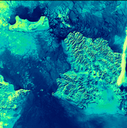
Verging on the Arctic Circle, the sea in this image is packed with ice floes. In the cracks and gaps between the ice, the much less-reflective water surface appears almost black. The brightest area is the finger of cloud on the western side of the image. Also brighter than the icy sea, are the three land areas in the picture. From the western side of the image, the eastern extremity of the Russian Federation reaches out towards the tip of Alaska. The International Date Line bisects the inter-continental gap and then veers south-west keeping St. Lawrence Island with Alaska a day behind the Russian Federation. ATSR data have proved very useful in the detection of sea ice and the location of icebergs.
(This is a 1.6 micron day-time image acquired on 5th February 1992; the area covered is 512 x 512 square km.)
From the western side of the image, the eastern extremity of the Russian Federation reaches out towards the tip of Alaska. The International Date Line bisects the inter-continental gap and then veers south-west keeping St. Lawrence Island with Alaska... What I HAVE been able to determine about the graphic is the people doing the captioning got things a little bass akwards. It's actually 180 degrees out of sync for example. North is south; Alaska is to the left(west?) and Russia is to the right(east?). Consequently, St. Lawrence Island appears to be NORTH of the strait; a line to the southwest would be a long time getting around to St. Lawrence.
Another item regarding your "caption" from your #88: Underwater Bering Strait:
Just curious Fred, are you a provocateur??? Or did I misunderstand your caption?