To: SunkenCiv
VIOLENT OUTFLOW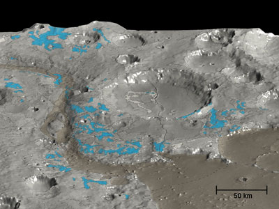
In this HRSC 3D perspective view of the Marwth Vallis area (shades of grey), OMEGA has mapped the water-rich minerals (blue). No hydrated minerals or sediments have been detected, either in the channel or in its opening. However, the outflow was so violent as to erode and expose ancient hydrated clay-rich minerals, tracing an early era when water was present.
12 posted on
11/05/2007 11:21:13 PM PST by
Fred Nerks
(Fair dinkum!)
To: Fred Nerks
:’) Ices (including water ices) normally locked up in the soil are released by the energy of impacts large and small. Impacts large enough to do so produce a short-lived atmosphere in a limited area, which yields a temporary atmospheric pressure permitting liquid water to exist. That’s why these apparent erosion patterns exist; IMV at least some of these are old, refrozen mud flows. Regardless, this is the reason that these “rivers” appear to arise from nowhere and flow nowhere. The conditions permitting liquid water to exist dissipate as the water vapor cools back into ice and precipitates.
13 posted on
11/06/2007 7:38:41 AM PST by
SunkenCiv
(Profile updated Monday, October 22, 2007. https://secure.freerepublic.com/donate/)
FreeRepublic.com is powered by software copyright 2000-2008 John Robinson