
Posted on 09/12/2018 1:53:29 PM PDT by NautiNurse
The National Hurricane Center has been issuing advisories for Hurricane Florence since August 30. The five day "Cone of Uncertainty" archive progression since Aug. 30 may be found here. As the super-size storm named Florence approached the U.S. Atlantic Coast, stories abound of people who are refusing to evacuate barrier islands.
The 82nd Airborne has relocated all of its assets, while FEMA is using Fort Bragg as a major staging area for post-storm supplies, including meals, water and cots. Fort Jackson (Columbia SC) has cancelled events including basic training graduation to prepare for military and civilian evacuees from coastal locations.
While hurricane preparations are rushed to completion, some stores are closing for lack of hurricane supplies inventory. Smart phone app Gas Buddy provides updates for gasoline availability along evacuation routes.
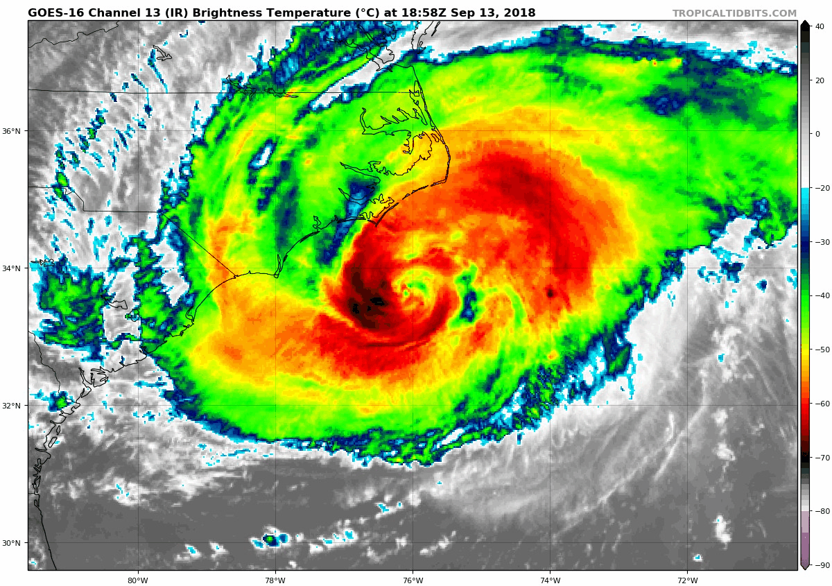
Wave heights to 83 ft. were recorded while Hurricane Florence churned 435 miles from Wilmington, NC. Storm surge is predicted to reach 6-13 ft along the coastline to the N of landfall. Steering currents are forecast to collapse at or near landfall, resulting in Florence meandering for days. This is expected to result in up to 40 inches of rainfall in isolated areas in the Carolinas, and up to a foot of rain in the Appalachian Mountains.
Tropical Storm Isaac: The government of France has issued Tropical Storm Warnings and Watches for the Lesser Antilles.
Invest 95L: The National Hurricane Center predicts 70% chance of development in the Gulf of Mexico. Limited forecast models, satellite graphics and GOM buoy info are available for Invest 95L below.
Mash the graphics below to enlarge. All links and images are self-updating.

Local Weather: |
Saw a mention that recon found hurricane force winds in the outer band to the SW of the storm - the weakest sector. So it has a very broad windfield.
I’m in the extreme NW corner of SC waiting to find out if this turns north to the east of me, or to the west.
If it’s to the east then we shouldn’t get much more than a heavy thunderstorm. If it’s to the west, that means the worst part will be sitting on top me for a while.
Tide is going out, low tide about now. When the camera moves left and then zooms in across the water to an old light house, that is Bald Head Island.
The overall mouth of the Cape Fear River at Southport is kinda’ surrounded by small islands.
From the National Park Service (though none of this should be surprisingly)...
https://www.nps.gov/cowp/planyourvisit/conditions.htm (Cowpens National Battlefield) - closing today
https://www.nps.gov/cong/planyourvisit/conditions.htm - Congaree National Park
https://www.nps.gov/kimo/planyourvisit/conditions.htm - Kings Mountain National Military Park - closing today
https://www.nps.gov/nisi/planyourvisit/conditions.htm - Ninety Six National Historic Site - closing today
Winds down to 100 mph... crawling at 5 mph
I’m near anderson
sounds about right
don’t think I’ll have to worry about picking up pecans again this year
Had an ocean front lot on North Topsail just North of the St Regis.
Sold it and my condo at the St Regis last year....
you’re a stone’s throw away from me then, so we’re probably looking at the same outcomes
The Communists will accuse Trump of sending the Air Force up to seed the storm and reduce its’ intensity..count on it! ;)

On/Off Hurricane List Mash Here--> 
Appreciate all your info and know those involved do also. Thanks again
Keeping your mother and those watching out for her in prayer.
In Gaffney here. Hoping the same, but looks like we are in the bullseye.
Strong surf in Ocean city, Md today
https://www.facebook.com/walterdorsettphotography/videos/421370821733217/
Bastardi is leaning with Euro at this stage, giving the Cape Fear area a double hit and showing Charleston a little action.
It’s inconceivable to think of the surge...
Looks to be tightening a bit.
Monster Flo.
Don’t despair on that point too soon, last couple of projection updates on both wind and rain intensity have been very positive for this area.
WOW. That is really scary to watch. May God bless and protect all of you in the storm surge path.
I hadn’t heard about the possible 2 ‘step’ surge process discussed here.
“
crankyweatherguy
@crankywxguy
Yep we have the blowout and then the sudden surge. Drop 3-5 feet, rise 3-5 back & then immediate surge 6-12 feet or so. It’s gunna rush in pretty nasty I’d assume, unless we’re over-valuing the remaining surge. I don’t think so.
@Snow_Mix_Studio
Replying to @crankywxguy
I hope people really understand that if she comes ashore wherever, the winds from the northeast as you show will shift to coming from the southeast thus pushing huge amounts of
Replying to
@crankywxguy
I hope people really understand that if she comes ashore wherever, the winds from the northeast as you show will shift to coming from the southeast thus pushing huge amounts of water inland. Surge may start gradually, then once wind shifts it could happen rapidly..tsunami effect
https://mobile.twitter.com/Snow_Mix_Studio/status/1040315211536842753
Disclaimer: Opinions posted on Free Republic are those of the individual posters and do not necessarily represent the opinion of Free Republic or its management. All materials posted herein are protected by copyright law and the exemption for fair use of copyrighted works.


