http://cdec.water.ca.gov/cdecapp/resapp/resDetailOrig.action?resid=ORO
Posted on 02/09/2017 3:59:32 PM PST by Texas Eagle
Interesting. Hasn’t your lake been very low for several years?
“Per @William Conelly
To all my friends, constituents, the truth about the Oroville Lake facility, if you live near the river or in any low lying areas take precautions move your equipment pick up your basements get some belongings together as there is no controlling of the emergency spill way. Period end of the BS being spread around. There is a good chance declining flows may help but why not be prepared. The out flow over the emergency spillway will be the total of the inflows into Lake Oroville. Again that total is dependant on weather conditions and precipitation. If the weather patterns change with colder conditions more snow or clearing skies we will be OK. But again it must be noted DWR screwed this up. They have lost the historic knowledge that Oroville Lake should be kept below the spillway most of the time as an event where warm rain falls on an above average snowpack may cause a need to use the spillway. It was not supposed to be used this often or so heavily depended upon. So they screwed the volume up to 70 thousand blew it up, then they claimed it was 50 thousand now even 35 thousand at least that is what Sacramento put out today.
So to recap the emergency spillway is going to release water in an UNCONTROLLED volume why take a chance get prepared. The season isn’t over yet neither is the regular spillway fixed and DWR is in charge.”
http://cdec.water.ca.gov/cdecapp/resapp/resDetailOrig.action?resid=ORO
Looks like it's heading upwards fast.
Yep, the emergency spillway is just North of the regular spillway (left in the following satellite photo): https://goo.gl/maps/HNijdc4g8qp It is lower than the top of the dam, so overtopping of the dam shouldn’t be possible. Oroville is currently at 89% of capacity...things could get interesting for the spillway(s) this spring. http://cdec.water.ca.gov/cgi-progs/reservoirs/RES
A former DWR engineer is recommending that they just release as per plan, the water will scour down to bedrock, and after the releases stop this summer repair the spillway.
More videos from the area from a local station: https://www.youtube.com/user/kcratv/videos
Not so. Look, I literally live right down the road from the dam dam...The spillway is toast which means they run water down the hillside channel. Barring that, then there is the Emergency Overflow, which is essentially letting the water flow over the top and down the hill and into the river. The spillway and overflow are off to one side of the dam itself. There is no danger to the integrity of the dam itself, just too much water coming in versus how much they can release.
20 years ago we faced a similar situation in where the dam crested a foot short of the top. The weather begins to clear tomorrow an through the weekend so that will help. There is lots of water coming off the hills and into the dam, but barring any future storms the next few days, it should all be fine.
The pictures are impressive but the dam is not going to fail. The spillway will fail, but that is not the end. Just wait for things to clear, throw some boulders into the spillway and concrete that puppy back up.
Like I said, I live here and things are just fine.
And Bill is right. Canyon Drive is down there along the river and with an uncontrolled spillage over the top, there is no way to predict outflow over the top. Those that live in the area SHOULD prepare in case things get sticky. That’s only prudent. Bill Connelly is Supervisor in this part of Butte County and he knows...The dam itself is not in danger of failing, but uncontrolled release COULD present problems. Bill’s advice is prudent for those homeowners living in the direct area. For someone like me, absolutely no danger whatsoever...we live on the other side of the dam.
Happy to hear it.
However I was thinking more of erosion under where the hole is. Since it is basically just dirt, how big of a hole will it create, and at what point would (with all the pressure of the water behind the dam) it give way opening a breech in the dam.
I of course only have news reports and pictures to go on. But if you feel safe then you must feel it will not happen.
I guess I have watched too many SECONDS TO DISASTERS. :)
It looks like that section of the spillway is far from the dam itself, and with a hillside of rock in between the spillway and dam. I’m guessing there is minimal to no risk of it migrating back to the dam.
In the photo on 10 with no water flow it looks like the reservoir is down quite aways. Is that a recent photo showing the rains have stopped and they drew it down far - or is it an older photo showing the damage was there before?
“Yeah Harry - I know we’re supposed to fix that spillway, but we’ve been at least 50 feet of water level below it for the last 7 years - what’s the hurry? It’s not like we got any spare water that needs spilling.”
Sort of like a leaky roof. When it’s raining you can’t fix it. When it’s not raining it don’t need fixing!
http://cdec.water.ca.gov/cdecapp/resapp/resDetailOrig.action?resid=ORO
It is broken all the way across the width of the spillway. It’s supposed to be full by Sunday. To the top full. The only good news is we are supposed to be dry from Sat-Wed.
Yep, lots of inflow and they shut down the spillway almost all day yesterday...I get 97.5% full now by my math (3449078 current AF divided by 3537577 AF capacity).
Looks like they are planning on releasing 65000 CFS down the busted spillway today...that should be impressive! 65000 + 69533 river release might be a problem downstream also. Inflow is about 143000 CFS...they are not quite keeping up with it.
http://cdec.water.ca.gov/cgi-progs/queryF?s=ORO&d=10-Feb-2017+07:38
We have a son-in-law who works at the dam so he calls our daughter with the latest info.
I will post anything we hear here.
“Oroville Dam is tallest dam in the US at 770 feet”
Liberals at work doing what they do best, screwing up everything!!!
Great questions: They have to use the emergency spillway, to get to and dry out the main spillway.
Apparently, this isn’t a new problem and funding was supposedly made available a couple of years ago.
However, apparently, in typical Moonbeam/Rat legislature, they funded the bullet train from nowhere to nowhere and of course illegal health care and other goodies.
We have a respite from big storms until later next week. That could be a mother of a storm with tons of rain and no place for it to go.
Apparently, the expensive aka good long range weather predictors are saying we will have an excess of rain until the end of March.
I wonder how practical it would be to pack the hole full of quick-set cement and bolt a lot of steel plates over it.
Then, seal the edges of the plates with some sort of asphalt, and put an aererator pipe upstream of it to minimize the cavitation/erosion of the water flowing over it.
I for one am happy that President Trump has ended the California drought.
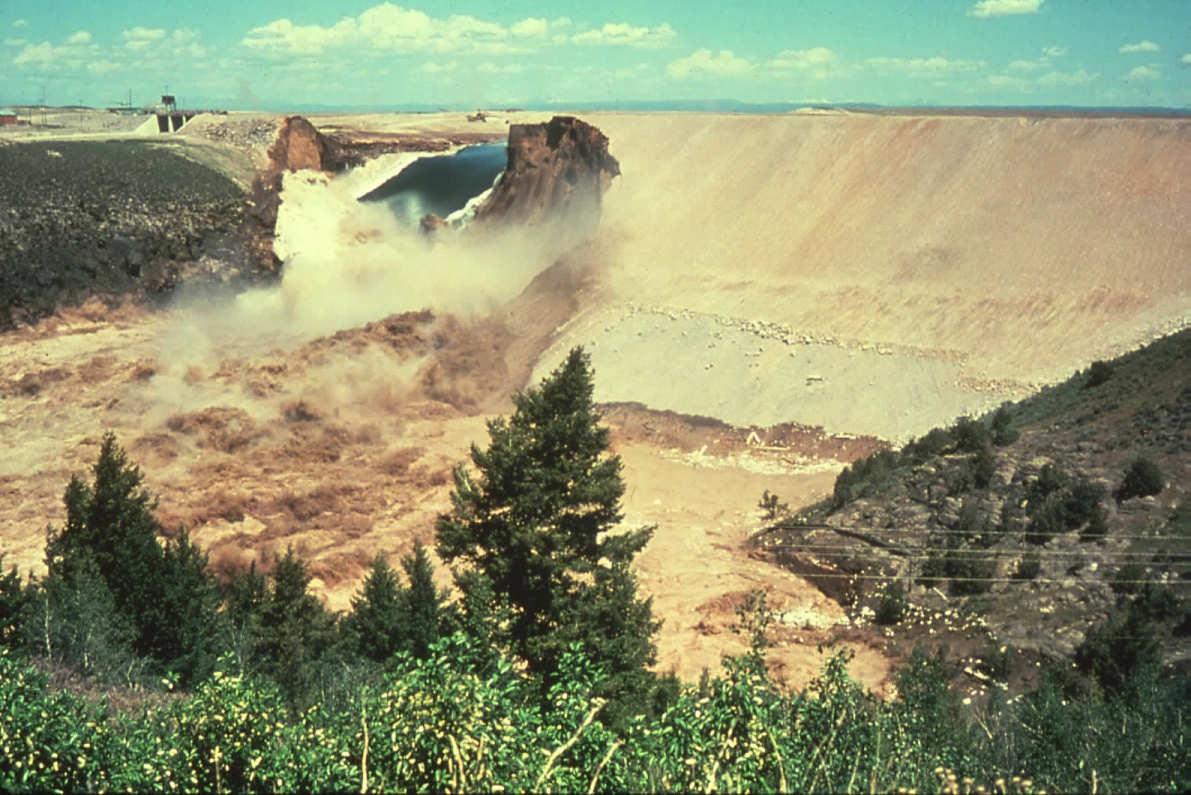
Water started coming over the emergency portion on the left at 8am Pacific time. That water is going to eat into the hill as it flows down to the Feather river below.
They took out trees on the hillside over the past two days and pulled down powerlines that passed through the area.erosion is going to eat up that hill.
They had to pull down power lines as they went over the area of the emergency overflow.
Disclaimer: Opinions posted on Free Republic are those of the individual posters and do not necessarily represent the opinion of Free Republic or its management. All materials posted herein are protected by copyright law and the exemption for fair use of copyrighted works.